దస్త్రం:Turkish Strait disambig.svg
Jump to navigation
Jump to search

ఈ ఫైలు SVG కు చెందిన ఈ మునుజూపు PNG పరిమాణం: 469 × 388 పిక్సెళ్ళు. ఇతర రిజల్యూషన్లు: 290 × 240 పిక్సెళ్ళు | 580 × 480 పిక్సెళ్ళు | 928 × 768 పిక్సెళ్ళు | 1,238 × 1,024 పిక్సెళ్ళు | 2,476 × 2,048 పిక్సెళ్ళు.
అసలు దస్త్రం (SVG ఫైలు, నామమాత్రంగా 469 × 388 పిక్సెళ్ళు, ఫైలు పరిమాణం: 90 KB)
This is a file from the Wikimedia Commons. Information from its description page there is shown below. Commons is a freely licensed media file repository. You can help. |
సారాంశం
| వివరణ |
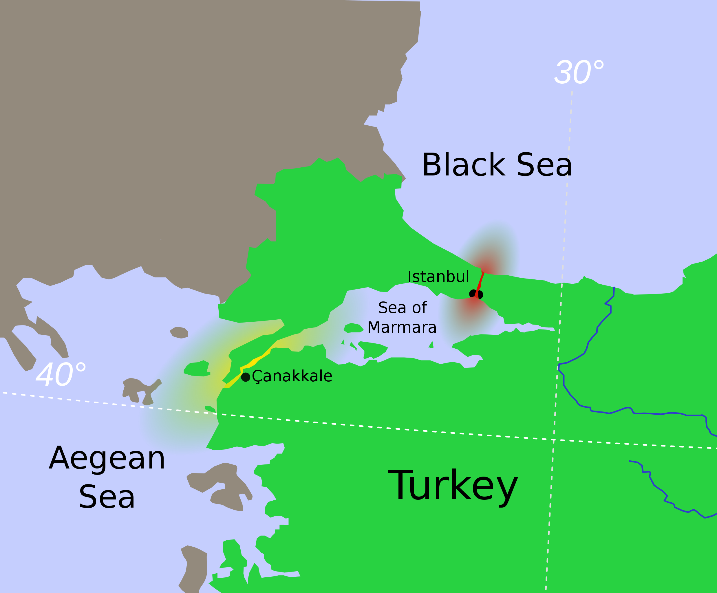
Hrvatski: Tjesnaci Bospor i Dardaneli Türkçe: Türk Boğazlarının harita üzerinde renkledirme ile açıklaması
Ελληνικά: τα Στενά του Βοσπόρου Українська: Турецькі протоки.
Босфор
Дарданелли मराठी: तुर्कस्तानमधील बोस्फोरस व डार्डेनेल्झ ह्या सामुद्रधुन्या 日本語: 海峡地帯(トルコ) |
||
| తేదీ | |||
| మూలం | Modified from File:Vertrag sevres otoman.svg, created by Thomas Steiner. | ||
| కర్త | User:Interiot | ||
| ఇతర కూర్పులు |
[]
|
||
| SVG పెరుగుదల |


.svg)


లైసెన్సింగ్
ఈ దస్త్రం క్రియేటివ్ కామన్స్ ఆపాదింపు-యథాతథ పంచుకోలు 2.5 సాధారణం లైసెన్సు క్రింద లభ్యం.
- ఇలా చేసేందుకు మీకు స్వేచ్ఛ ఉంది:
- పంచుకోడానికి – ఈ కృతిని కాపీ చేసుకోవచ్చు, పంపిణీ చేయవచ్చు, ప్రసారమూ చేయవచ్చు
- రీమిక్స్ చేయడానికి – కృతిని అనుకరించడానికి
- క్రింది షరతులకు లోబడి:
- ఆపాదింపు – సముచితమైన శ్రేయస్సును ఇవ్వాలి, లైసెన్సుకు లింకు ఇవ్వాలి, మార్పులేమైనా చేస్తే వాటిని సూచించాలి. అందుకు సముచితమైన పద్ధతి దేన్నైనా అవలంబించవచ్చు. కానీ మీకూ మీ వాడుకకూ హక్కుదారు అనుమతించారు అనే అర్థం వచ్చేటట్లుగా మాత్రం కాదు.
- share alike – మీరు ఈ కృతిని అనుకరిస్తే, మారిస్తే, లేదా మెరుగుపరిస్తే తత్ఫలిత కృతిని ఇదే లైసెన్సు లేదా దీనికి అనుగుణ్యమైన లైసెన్సు క్రింద మాత్రమే పంపిణీ చేయాలి.
అసలు ఎక్కింపుల చిట్టా
The original description page was here. All following user names refer to en.wikipedia.
- 2007-01-16 22:04 Interiot 469×388× (94044 bytes) oops
- 2007-01-16 20:59 Interiot 469×388× (122640 bytes) actually, make it clear that Istanbul straddles the strait
- 2007-01-16 20:47 Interiot 469×388× (90212 bytes) Disambiguation for [[Turkish Straights]]. Modified from [[:Image:Vertrag sevres otoman.svg]], created by [[:de:Benutzer:Thire|Thomas Steiner]]. {{cc-by-sa-2.5}}
ఫైలు చరితం
తేదీ/సమయం ను నొక్కి ఆ సమయాన ఫైలు ఎలా ఉండేదో చూడవచ్చు.
| తేదీ/సమయం | నఖచిత్రం | కొలతలు | వాడుకరి | వ్యాఖ్య | |
|---|---|---|---|---|---|
| ప్రస్తుత | 06:21, 26 జనవరి 2012 | | 469 × 388 (90 KB) | OgreBot | (BOT): Reverting to most recent version before archival |
| 06:21, 26 జనవరి 2012 |  | 469 × 388 (92 KB) | OgreBot | (BOT): Uploading old version of file from en.wikipedia; originally uploaded on 2007-01-16 22:04:20 by Interiot | |
| 06:21, 26 జనవరి 2012 |  | 469 × 388 (120 KB) | OgreBot | (BOT): Uploading old version of file from en.wikipedia; originally uploaded on 2007-01-16 20:59:55 by Interiot | |
| 06:21, 26 జనవరి 2012 |  | 469 × 388 (88 KB) | OgreBot | (BOT): Uploading old version of file from en.wikipedia; originally uploaded on 2007-01-16 20:47:38 by Interiot | |
| 16:16, 19 డిసెంబరు 2008 |  | 469 × 388 (90 KB) | RafaAzevedo | {{Information |Description={{en|1=Disambiguation for Turkish Straits. {{legend|#eb0000|Bosporus Strait}} {{legend|#ffe605|Dardanelles Strait}} == License == Modified from Image:Vertrag sevres otoman.svg, created by |
లింకులు
కింది పేజీలలో ఈ ఫైలుకు లింకులు ఉన్నాయి:
సార్వత్రిక ఫైలు వాడుక
ఈ దస్త్రాన్ని ఈ క్రింది ఇతర వికీలు ఉపయోగిస్తున్నాయి:
- af.wikipedia.org లో వాడుక
- ar.wikipedia.org లో వాడుక
- azb.wikipedia.org లో వాడుక
- az.wikipedia.org లో వాడుక
- bg.wikipedia.org లో వాడుక
- bn.wikipedia.org లో వాడుక
- bs.wikipedia.org లో వాడుక
- ca.wikipedia.org లో వాడుక
- da.wikipedia.org లో వాడుక
- el.wikipedia.org లో వాడుక
- en.wikipedia.org లో వాడుక
- Bosporus
- Dardanelles
- Montreux Convention Regarding the Regime of the Straits
- Sea of Marmara
- Dardanus (son of Zeus)
- Truman Doctrine
- Gallipoli campaign
- Landing at Cape Helles
- Naval operations in the Dardanelles campaign
- London Straits Convention
- Treaty of Hünkâr İskelesi
- Chanak Crisis
- Turkish straits
- Constantinople Agreement
- Turkish straits crisis
- User:Chickstarr404/Gather lists/13386 – "A Travelers Alphabet" by Stephen Runciman
- International Straits Commission
- User:Abyssal/bla
- en.wiktionary.org లో వాడుక
ఈ దస్త్రపు మరింత సార్వత్రిక వాడుకను చూడండి.