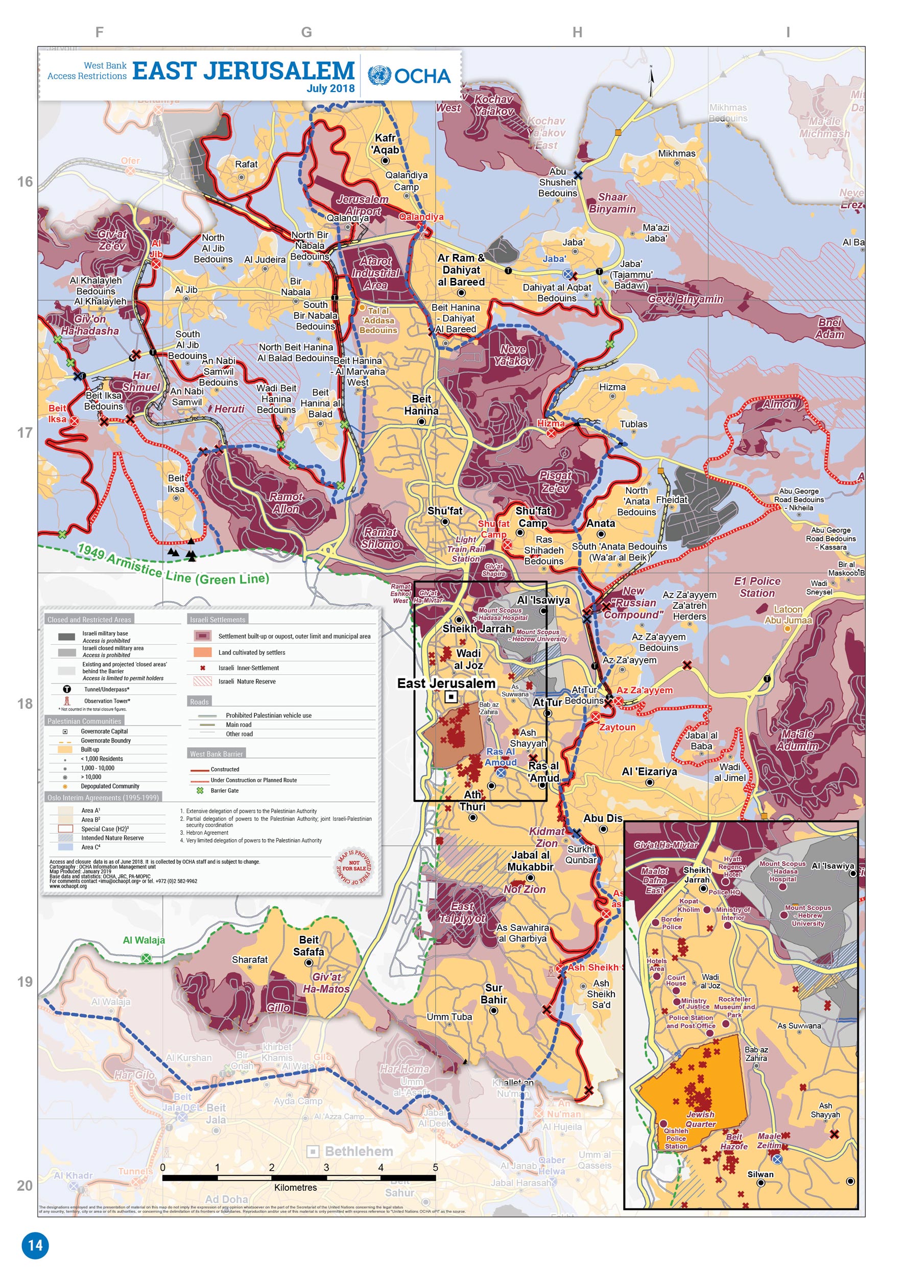
దస్త్రం:UN map of Israeli Inner Settlement Ring around Jerusalem.jpg

అసలు దస్త్రం (1,161 × 1,595 పిక్సెళ్ళు, ఫైలు పరిమాణం: 1.38 MB, MIME రకం: image/jpeg)
This is a file from the Wikimedia Commons. Information from its description page there is shown below. Commons is a freely licensed media file repository. You can help. |
సారాంశం
| వివరణ |
English: UN map of Israeli Inner Settlement Ring around Jerusalem |
| తేదీ | |
| మూలం |
https://www.ochaopt.org/atlas2019/images/db/wb-closure/16.jpg |
| కర్త | United Nations OCHA oPt |
లైసెన్సింగ్
| This image is a map derived from a United Nations map.
Unless stated otherwise, UN maps are to be considered in the public domain. This applies worldwide. UN maps are, in principle, open source material and you can use them in your work or for making your own map. UN requests however that you delete the UN name, logo and reference number upon any modification to the map. Content of your map will be your responsibility. You can state in your publication, if you wish, something like: based on UN map … (map name, map number, revision number and date). See: Geospatial Information Section. And: Geospatial, location data for a better world. |
 |
ఫైలు చరితం
తేదీ/సమయం ను నొక్కి ఆ సమయాన ఫైలు ఎలా ఉండేదో చూడవచ్చు.
| తేదీ/సమయం | నఖచిత్రం | కొలతలు | వాడుకరి | వ్యాఖ్య | |
|---|---|---|---|---|---|
| ప్రస్తుత | 09:06, 2 ఏప్రిల్ 2019 | | 1,161 × 1,595 (1.38 MB) | Onceinawhile | User created page with UploadWizard |
లింకులు
కింది పేజీలలో ఈ ఫైలుకు లింకులు ఉన్నాయి:
సార్వత్రిక ఫైలు వాడుక
ఈ దస్త్రాన్ని ఈ క్రింది ఇతర వికీలు ఉపయోగిస్తున్నాయి:
- ar.wikipedia.org లో వాడుక
- en.wikipedia.org లో వాడుక
- nl.wikipedia.org లో వాడుక
- no.wikipedia.org లో వాడుక
- zh.wikipedia.org లో వాడుక