దస్త్రం:Vatican City map EN.png
Jump to navigation
Jump to search

ఈ మునుజూపు పరిమాణం: 777 × 600 పిక్సెళ్ళు. ఇతర రిజల్యూషన్లు: 311 × 240 పిక్సెళ్ళు | 622 × 480 పిక్సెళ్ళు | 995 × 768 పిక్సెళ్ళు | 1,280 × 988 పిక్సెళ్ళు | 2,560 × 1,977 పిక్సెళ్ళు | 2,888 × 2,230 పిక్సెళ్ళు.
అసలు దస్త్రం (2,888 × 2,230 పిక్సెళ్ళు, ఫైలు పరిమాణం: 2.41 MB, MIME రకం: image/png)
This is a file from the Wikimedia Commons. Information from its description page there is shown below. Commons is a freely licensed media file repository. You can help. |
సారాంశం
| Description |
Deutsch: Karte der Vatikanstadt (englische Version)
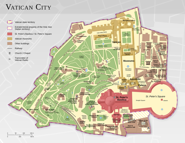
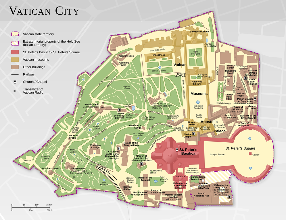
English: Map of the Vatican City (English version)
Español: Mapa de la Ciudad del Vaticano (versión en inglés).
Suomi: Vatikaanin kartta (englanninkielinen versio)
Français : Carte de la Cité du Vatican, à partir d'informations d'OpenStreetMap. Version en anglais ; voir la version en français ici : Vatican City map FR.png
中文:梵蒂冈城国地图(英语版本)
Bosanski: Karta Vatikana - sadrži kartografske podatke sa projekta ©OpenStreetMap (ODbL).
|
|||||||||
| తేదీ | ||||||||||
| మూలం |
స్వంత కృతి |
|||||||||
| స్రష్ట | ||||||||||
| అనుమతి (ఈ దస్త్రాన్ని పునర్వినియోగించుకోవడం) |
|
|||||||||
| Geotemporal data | ||||||||||
| Bounding box |
|
|||||||||
| Georeferencing | ||||||||||
| ఇతర కూర్పులు |
|
|||||||||


|
This map has been made or improved in the German Kartenwerkstatt (Map Lab). You can propose maps to improve as well.
|
లైసెన్సింగ్
ఈ దస్త్రం క్రియేటివ్ కామన్స్ Attribution-Share Alike 3.0 Unported లైసెన్సు క్రింద లభ్యం.
ఆపాదింపు: Thomas Römer/OpenStreetMap data
- ఇలా చేసేందుకు మీకు స్వేచ్ఛ ఉంది:
- పంచుకోడానికి – ఈ కృతిని కాపీ చేసుకోవచ్చు, పంపిణీ చేయవచ్చు, ప్రసారమూ చేయవచ్చు
- రీమిక్స్ చేయడానికి – కృతిని అనుకరించడానికి
- క్రింది షరతులకు లోబడి:
- ఆపాదింపు – సముచితమైన శ్రేయస్సును ఇవ్వాలి, లైసెన్సుకు లింకు ఇవ్వాలి, మార్పులేమైనా చేస్తే వాటిని సూచించాలి. అందుకు సముచితమైన పద్ధతి దేన్నైనా అవలంబించవచ్చు. కానీ మీకూ మీ వాడుకకూ హక్కుదారు అనుమతించారు అనే అర్థం వచ్చేటట్లుగా మాత్రం కాదు.
- share alike – మీరు ఈ కృతిని అనుకరిస్తే, మారిస్తే, లేదా మెరుగుపరిస్తే తత్ఫలిత కృతిని ఇదే లైసెన్సు లేదా దీనికి అనుగుణ్యమైన లైసెన్సు క్రింద మాత్రమే పంపిణీ చేయాలి.
Assessment
|

This image was selected as picture of the day on Wikimedia Commons for 11 February 2015. It was captioned as follows: Other languages:
Bosanski: Karta Vatikana - sadrži kartografske podatke sa projekta ©OpenStreetMap (ODbL). |
ఫైలు చరితం
తేదీ/సమయం ను నొక్కి ఆ సమయాన ఫైలు ఎలా ఉండేదో చూడవచ్చు.
| తేదీ/సమయం | నఖచిత్రం | కొలతలు | వాడుకరి | వ్యాఖ్య | |
|---|---|---|---|---|---|
| ప్రస్తుత | 11:44, 12 ఫిబ్రవరి 2021 | | 2,888 × 2,230 (2.41 MB) | Foghe | St. Damasco → St. Damaso. |
| 09:22, 11 ఏప్రిల్ 2013 |  | 2,888 × 2,230 (2.14 MB) | Thoroe | larger render | |
| 17:12, 10 ఏప్రిల్ 2013 |  | 1,733 × 1,338 (1.11 MB) | Thoroe | small fixes | |
| 15:59, 23 మార్చి 2013 |  | 1,733 × 1,338 (1.1 MB) | Thoroe | minor fixes | |
| 00:41, 23 మార్చి 2013 |  | 1,733 × 1,338 (1.09 MB) | Thoroe | {{Information |Description ={{en|1=Map of the Vatican City (English version)}} {{de|1=Karte der Vatikanstadt (englische Version)}} |Source ={{own}} *[http://www.vatican.va/news_services/press/docume... |
లింకులు
ఈ ఫైలును వాడుతున్న పేజీలు లేవు.
సార్వత్రిక ఫైలు వాడుక
ఈ దస్త్రాన్ని ఈ క్రింది ఇతర వికీలు ఉపయోగిస్తున్నాయి:
- af.wikipedia.org లో వాడుక
- be-tarask.wikipedia.org లో వాడుక
- ca.wikipedia.org లో వాడుక
- crh.wikipedia.org లో వాడుక
- cv.wikipedia.org లో వాడుక
- de.wikipedia.org లో వాడుక
- en.wikipedia.org లో వాడుక
- Wikipedia:Featured pictures/Diagrams, drawings, and maps/Maps
- Talk:Vatican City/Archive 1
- User talk:Thoroe
- Wikipedia:Featured pictures thumbs/37
- User talk:Crisco 1492/Archive 44
- Wikipedia:Featured picture candidates/Vatican City map
- Wikipedia:Featured picture candidates/October-2013
- Wikipedia:Picture of the day/August 2015
- Template:POTD/2015-08-07
- Wikipedia:Main Page history/2015 August 7
- User:John Paul II/Line of Popes
- Portal:Geography/Selected picture
- User:ਕਰਨ 13/sandbox
- en.wikivoyage.org లో వాడుక
- fo.wikipedia.org లో వాడుక
- fr.wikipedia.org లో వాడుక
- hu.wikipedia.org లో వాడుక
- ka.wikipedia.org లో వాడుక
- ko.wikipedia.org లో వాడుక
- krc.wikipedia.org లో వాడుక
- lbe.wikipedia.org లో వాడుక
- www.mediawiki.org లో వాడుక
- mg.wikipedia.org లో వాడుక
- os.wikipedia.org లో వాడుక
- pl.wikipedia.org లో వాడుక
- pt.wikipedia.org లో వాడుక
- ru.wikipedia.org లో వాడుక
- ru.wikinews.org లో వాడుక
- sah.wikipedia.org లో వాడుక
- sv.wikipedia.org లో వాడుక
- tr.wikipedia.org లో వాడుక
- tt.wikipedia.org లో వాడుక
ఈ దస్త్రపు మరింత సార్వత్రిక వాడుకను చూడండి.