దస్త్రం:World 1914 empires colonies territory.PNG
Jump to navigation
Jump to search

ఈ మునుజూపు పరిమాణం: 800 × 330 పిక్సెళ్ళు. ఇతర రిజల్యూషన్లు: 320 × 132 పిక్సెళ్ళు | 640 × 264 పిక్సెళ్ళు | 1,522 × 628 పిక్సెళ్ళు.
అసలు దస్త్రం (1,522 × 628 పిక్సెళ్ళు, ఫైలు పరిమాణం: 45 KB, MIME రకం: image/png)
This is a file from the Wikimedia Commons. Information from its description page there is shown below. Commons is a freely licensed media file repository. You can help. |

|
This map image could be re-created using vector graphics as an SVG file. This has several advantages; see Commons:Media for cleanup for more information. If an SVG form of this image is available, please upload it and afterwards replace this template with
{{vector version available|new image name}}.
It is recommended to name the SVG file “World 1914 empires colonies territory.svg”—then the template Vector version available (or Vva) does not need the new image name parameter. |
సారాంశం
| వివరణ |
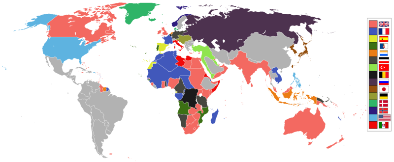
English: World empires and colonies in 1914, just before the First World War.
|
||||||||||||||||
| తేదీ | |||||||||||||||||
| మూలం | స్వంత కృతి | ||||||||||||||||
| కర్త | Andrew0921 | ||||||||||||||||
.jpg)
._LOC_2001620596.jpg)
British Empire
France
Spain
Portugal
Netherlands
German Empire
Ottoman
Belgium
Russia
Japan
Denmark
Norway
United States of America
Italy
Independent/other countries
లైసెన్సింగ్
నేను, ఈ కృతి యొక్క కాపీహక్కుదారుని, దీన్ని ఈ లైసెన్సు క్రింద ఇందుమూలముగా ప్రచురిస్తున్నాను:
ఈ ఫైలు అనుమతి సాధారణ సృజనాత్మకము అపాదింపు ౩.౦ ఆన్-పోర్టెడ్ యందు అనుమతించబడినది.
- ఇలా చేసేందుకు మీకు స్వేచ్ఛ ఉంది:
- పంచుకోడానికి – ఈ కృతిని కాపీ చేసుకోవచ్చు, పంపిణీ చేయవచ్చు, ప్రసారమూ చేయవచ్చు
- రీమిక్స్ చేయడానికి – కృతిని అనుకరించడానికి
- క్రింది షరతులకు లోబడి:
- ఆపాదింపు – సముచితమైన శ్రేయస్సును ఇవ్వాలి, లైసెన్సుకు లింకు ఇవ్వాలి, మార్పులేమైనా చేస్తే వాటిని సూచించాలి. అందుకు సముచితమైన పద్ధతి దేన్నైనా అవలంబించవచ్చు. కానీ మీకూ మీ వాడుకకూ హక్కుదారు అనుమతించారు అనే అర్థం వచ్చేటట్లుగా మాత్రం కాదు.
ఫైలు చరితం
తేదీ/సమయం ను నొక్కి ఆ సమయాన ఫైలు ఎలా ఉండేదో చూడవచ్చు.
| తేదీ/సమయం | నఖచిత్రం | కొలతలు | వాడుకరి | వ్యాఖ్య | |
|---|---|---|---|---|---|
| ప్రస్తుత | 09:28, 8 నవంబరు 2021 | | 1,522 × 628 (45 KB) | Randomastwritter | jubaland |
| 00:00, 14 ఏప్రిల్ 2021 |  | 1,522 × 628 (45 KB) | Offa29 | Fixed Togoland colour | |
| 18:57, 24 ఏప్రిల్ 2020 |  | 1,522 × 628 (45 KB) | The- | Norwegian flag | |
| 17:08, 24 ఏప్రిల్ 2020 |  | 1,522 × 628 (45 KB) | The- | If an old map with wrongly drawn borders is replaced with a better map wth a minor colour error, then fix that minor colour error. Don't just blithely revert to the bad old map. | |
| 21:52, 17 మార్చి 2020 |  | 1,474 × 620 (36 KB) | Makkkkus | Replaced the Swedish-Norwegian union flag with the Norwegian flag. | |
| 19:25, 13 మార్చి 2020 |  | 1,474 × 620 (22 KB) | Morris-frank | The new version introduced a big regression (coloring spain in the color of italy), also it did not contribute anything useful. | |
| 21:49, 14 ఆగస్టు 2019 |  | 1,522 × 628 (45 KB) | The- | More accurate map | |
| 12:47, 5 జూలై 2016 |  | 1,474 × 620 (22 KB) | Maproom | Removed borders between provinces of Australia, as requested at https://en.wikipedia.org/wiki/Wikipedia:Graphics_Lab/Map_workshop#FIFA_World_Cup_Maps_-_Colonial_Boundaries , because it had been united into a single dominion before 1914. | |
| 00:00, 26 డిసెంబరు 2010 |  | 1,474 × 620 (33 KB) | Quigley | by 1914, Qing Dynasty had collapsed and Republic of China established | |
| 13:56, 22 నవంబరు 2010 |  | 1,474 × 620 (20 KB) | AnonMoos | cropping margins, increasing PNG compression |
లింకులు
కింది పేజీలలో ఈ ఫైలుకు లింకులు ఉన్నాయి:
సార్వత్రిక ఫైలు వాడుక
ఈ దస్త్రాన్ని ఈ క్రింది ఇతర వికీలు ఉపయోగిస్తున్నాయి:
- af.wikipedia.org లో వాడుక
- ar.wikipedia.org లో వాడుక
- azb.wikipedia.org లో వాడుక
- bn.wikipedia.org లో వాడుక
- ca.wikipedia.org లో వాడుక
- da.wikipedia.org లో వాడుక
- en.wikipedia.org లో వాడుక
- eo.wikipedia.org లో వాడుక
- eo.wikiquote.org లో వాడుక
- es.wikipedia.org లో వాడుక
- fa.wikipedia.org లో వాడుక
- fi.wikipedia.org లో వాడుక
- fr.wikipedia.org లో వాడుక
- fy.wikipedia.org లో వాడుక
- gl.wikipedia.org లో వాడుక
- hu.wikipedia.org లో వాడుక
- it.wikipedia.org లో వాడుక
- ja.wikipedia.org లో వాడుక
- jv.wikipedia.org లో వాడుక
- ka.wikipedia.org లో వాడుక
- lv.wikipedia.org లో వాడుక
- mk.wikipedia.org లో వాడుక
- ml.wikipedia.org లో వాడుక
- oc.wikipedia.org లో వాడుక
- pt.wikipedia.org లో వాడుక
- ta.wikipedia.org లో వాడుక
- th.wikipedia.org లో వాడుక
ఈ దస్త్రపు మరింత సార్వత్రిక వాడుకను చూడండి.