మొరేనా జిల్లా
మొరేనా జిల్లా
MOrena जिला | |
|---|---|
 మధ్య ప్రదేశ్ పటంలో మొరేనా జిల్లా స్థానం | |
| దేశం | భారతదేశం |
| రాష్ట్రం | మధ్య ప్రదేశ్ |
| డివిజను | Chambal |
| ముఖ్య పట్టణం | Morena |
| మండలాలు | 1. Morena, 2. Ambah, 3. Porsa, 4. Joura, 5. Sabalgarh and 6. Kailaras |
| Government | |
| • లోకసభ నియోజకవర్గాలు | మోరెనా (shared with Sheopur district) |
| • శాసనసభ నియోజకవర్గాలు | 1. సబల్ఘర్, 2. జౌరా, 3. సుమావలి, 4. మోరెనా, 5. దిమాని and 6. అంబా |
| Area | |
| • మొత్తం | 4,998 km2 (1,930 sq mi) |
| Population (2011) | |
| • మొత్తం | 19,65,137 |
| • Density | 390/km2 (1,000/sq mi) |
| • Urban | 22.56 |
| జనాభా వివరాలు | |
| • అక్షరాస్యత | 72.1 |
| • లింగ నిష్పత్తి | 839 |
| ప్రధాన రహదార్లు | NH3 |
| Website | అధికారిక జాలస్థలి |
మొరేనా జిల్లా (హిందీ: मुरैना जिला) మధ్యప్రదేశ్ రాష్ట్ర జిల్లాలలో ఒకటి.మొరేనా జిల్లా చంబల్ డివిజన్లో భాగం.జిల్లాకేంద్రంగా మొరేనా పట్టణం ఉంది. 2011 గణాంకాల ఆధారంగా జిల్లా జనసంఖ్య 1,965,137. జనసాంధ్రతాపరంగా మొరేనా జిల్లా రాహ్ట్రంలో 5వ స్థానంలో ఉంది. మొదటి స్థానాలలో భోపాల్, ఇండోర్,జబల్పూర్, గ్వాలియర్ జిల్లాలు ఉన్నాయి. జిల్లాలో వ్యవసాయ భూములు అధికంగా ఉన్నాయి. రవాణా కొరకు అధికంగా రైలుమార్గం మీద ఆధారపడుతుంటారు. మొరేనా జిల్లాలో 15% గ్రామాలు మాత్రమే రైలుమార్గంతో అనుసంధానితమై ఉన్నాయి. మొరేనా జిల్లా ఆవాలపంటకు ప్రసిద్ధం. జిల్లాలో ప్రఖ్యాత కె.ఎస్. ఆయిల్ సంస్థ ఉంది. జిల్లాలో యాదవులు, రాజపుత్రులు అధికసంఖ్యలో ఉన్నారు.[1] జిల్లాలో ప్రబల బందిపోటు దొంగ " పాన్ సింగ్ తోమర్ " ఉండేవాడు.
పేరు వెనుక చరిత్ర[మార్చు]

మొరేనా అనే పేరుకు మొర్ + రైనా (అంటే నెమలి) అని అర్ధం. ఈప్రాంతంలో నెమళ్ళు అధికంగా ఉండడమే అందుకు కారణం. భారతదేశంలో అత్యధికసంఖ్యలో నెమళ్ళు నివసిస్తున్న ఏకైక జిల్లాగా మొరేనా ఉండవచ్చని భావించబడుతుంది.మొరేనా పట్టణం జిల్లాకు కేంద్రంగా ఉంది కనుక జిల్లాకు మొరేనా అనేపేరు నిర్ణయించబడింది.
చరిత్ర[మార్చు]
మునుపటి గ్వాలియర్ రాజ్యంలోని తంవార్గర్ జిల్లా నుండి కొంత భూభాగం విడతీసి ప్రస్తుత మొరన జిల్లాలో చేర్చబడింది.1947లో స్వత్రంత్రం వచ్చిన తరువాత గ్వాలియర్ రాజాస్థానం ప్రభుత్వంలో చేర్చబడింది. అలాగే మొరేనా జిల్లా దక్షిణ సరిహద్దులో పహర్గర్ రాజాస్థానం ఉండేది. స్వతంత్రం వచ్చిన తరువాత మొరేనా జిల్లా " మధ్య భారత్లో చేర్చబడింది. 1956 నవంబర్ 1న మొరేనా జిల్లా మధ్య ప్రదేశ్ రాష్ట్రంలో చేర్చబడింది.
భౌగోళికం[మార్చు]
మొరేనాా 26-30 డిగ్రీల ఉత్తర అక్షాంశం , 78-00 డిగ్రీల తూర్పు రేఖాంశంలో ఉంది. భౌగోళికంగా మొరేనా జిల్లా మధ్యప్రదేశ్ రాష్ట్రంలో రెండు రాష్ట్రాల సరిహద్దులను కలిగి ఉన్న జిల్లాగా ప్రత్యేకత కలిగి ఉంది. జిల్లా సరిహద్దులో రాజస్తాన్ , ఉత్తర ప్రదేశ్ సరిహద్దులు ఉన్నాయి. జిల్లా వాయవ్య సరిహద్దులో ధౌల్పూర్ జిల్లా (రాజస్తాన్) , ఈశాన్య సరిహద్దులో పినాహత్ (ఆగ్రా ఉత్తరప్రదేశ్) ఉన్నాయి.జిల్లా పొరుగునా భిండ్ జిల్లా, గ్వాలియర్ జిల్లా, శివ్పురి జిల్లా, షియోపూర్ జిల్లా ఉన్నాయి.
విభాగాలు[మార్చు]
మొరేనా జిల్లాలో 4 ఉపవిభాగాలు ఉన్నాయి: మొరేనా, అంబాహ్, జౌరా , సబల్గర్. మొరేనా ఉపవిభాగంలో లోనె తాలూకా ఉంది. అంబాహ్ ఉపవిభాగంలో అంబాహ్ , పొర్సా అనే రెండు తాలూకాలు , మండలాలు ఉన్నాయి. జౌరా ఉపవిభాగంలో జౌరా తాలూకా , రెండు మండలాలు ఉన్నాయి: జౌరా , పహర్గర్. సబల్గర్ ఉపవిభాగంలో రెండు తాలూకాలు ఉన్నాయి: సబల్గర్ , కైలరాస్. జిల్లాలో మొరేనా, బామర్, అంబాహ్, పొర్సా, జౌరా, సదల్గర్, కైలారస్ , ఝుండ్పురా మొదలైన ప్రధాన పట్టణాలు ఉన్నాయి.
జిల్లాలో 6 అసెంబ్లీ నియోజకవర్గాలు ఉన్నాయి: సబల్గర్ అసెంబ్లీ నియోజకవర్గం, జౌరా అసెంబ్లీ నియోజకవర్గం, సుమావలి అసెంబ్లీ నియోజకవర్గం, మొరేనా అసెంబ్లీ నియోజకవర్గం, దిమని అసెంబ్లీ నియోజకవర్గం , అంబాహ్ అసెంబ్లీ నియోజకవర్గం.ఈ 6 నియోజక వర్గాలు మొరేనా పార్లమెంటు నియోజక వర్గంలో భాగంగా ఉన్నాయి.[2]
2001 లో గణాంకాలు[మార్చు]
| విషయాలు | వివరణలు |
|---|---|
| జిల్లా జనసంఖ్య . | 1,965,137,[3] |
| ఇది దాదాపు. | లెసొథొ దేశ జనసంఖ్యకు సమానం.[4] |
| అమెరికాలోని. | న్యూమెక్సికో నగర జనసంఖ్యకు సమం..[5] |
| 640 భారతదేశ జిల్లాలలో. | 236 వ స్థానంలో ఉంది.[3] |
| 1చ.కి.మీ జనసాంద్రత. | 394 [3] |
| 2001-11 కుటుంబనియంత్రణ శాతం. | 23.38%.[3] |
| స్త్రీ పురుష నిష్పత్తి. | 839:1000 [3] |
| జాతియ సరాసరి (928) కంటే. | |
| అక్షరాస్యత శాతం. | 72.07%.[3] |
| జాతియ సరాసరి (72%) కంటే. |
ప్రముఖ వ్యక్తుల[మార్చు]
- సేథ్ గిర్వర్ లాల్ ప్యారే లాల్; ప్రముఖ వ్యాపార వేత్త, సేథ్ గిర్వర్ లాల్ ప్యారే లాల్ శిక్షా ట్రస్ట్ వ్యవస్థాపకుడు.
- రామ్ ప్రసాద్ బిస్మిల్; భారతీయ విప్లవకారుడు విల్లగె- (బర్బై) మొరేనా
- పాన్ సింగ్ తోమర్; ప్రముఖ అథ్లెట్ భిదొస (మొరేనా)
- రమేష్ గార్గ్ చైర్మన్ కే.యస్ నూనెలు
- అటల్ బిహారీ వాజ్పాయ్ మాజీ ప్మ్ (బతెస్వర్)
- అశోక్ చవిరం అర్గల్; (సభ్యుడు పార్లమెంట్ 4 సార్లు ంఒరెన & 1 సమయం బింద్)
ఆహార సంస్కృతి[మార్చు]
మొరేనాా జిల్లాలో ప్రారంభించబడిన " గజక్ " అనే స్వీట్ చాలాప్రాబల్యత సంతరించుకుంది. ఇది అధికంగా శీతాకలంలో తయారుచేయబడుతుంది. దీనిని నువ్వులు, బెల్లంతో తయారు చేస్తారు. మొరేనాా బేడై కూడా ప్రాబల్యత కలిగి ఉంది. అలాగే గుజియా, పేడే కూడా ప్రాబల్యత కలిగి ఉన్నాయి.
చిత్రమాలిక[మార్చు]
- చౌసత్ యోగిని ఆలయం, మోరెనా
-
 Chausath Yogini Temple, on a hill
 -
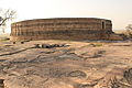 Chausath Yogini Temple, circular in plan like other Yogini temples
 -
 Outer facade has recesses and projections with small rathas and deities carved into them
 -
 Door jamb
 -
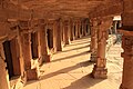 Inner corridor with subsidiary shrines of Shiva Lingams


మూలాలు[మార్చు]
- ↑ "ఆర్కైవ్ నకలు" (PDF). Archived from the original (PDF) on 2016-03-04. Retrieved 2014-11-23.
- ↑ "Delimitation of Parliamentary and Assembly Constituencies Order, 2008" (PDF). The Election Commission of India. pp. 226, 250. Archived from the original (PDF) on 2010-10-05. Retrieved 2014-11-23.
- ↑ 3.0 3.1 3.2 3.3 3.4 3.5 "District Census 2011". Census2011.co.in. 2011. Retrieved 2011-09-30.
- ↑ US Directorate of Intelligence. "Country Comparison:Population". Archived from the original on 2011-09-27. Retrieved 2011-10-01.
Lesotho 1,924,886
- ↑ "2010 Resident Population Data". U. S. Census Bureau. Archived from the original on 2011-08-23. Retrieved 2011-09-30.
New Mexico - 2,059,179
భౌగోళిక స్థానం[మార్చు]
Places adjacent to మొరేనా జిల్లా | ||||||||||||||||
|---|---|---|---|---|---|---|---|---|---|---|---|---|---|---|---|---|
| ||||||||||||||||
వెలుపలి లింకులు[మార్చు]
- క్లుప్త వివరణ ఉన్న articles
- Pages using infobox settlement with bad settlement type
- Pages using infobox settlement with no coordinates
- Articles containing Hindi-language text
- Commons category link from Wikidata
- మధ్య ప్రదేశ్ జిల్లాలు
- భారతదేశం లోని జిల్లాలు
- హిందీ భాషా పాఠాన్ని కలిగి ఉన్న వ్యాసాలు
- మొరెన జిల్లా