దర్రాంగ్ జిల్లా: కూర్పుల మధ్య తేడాలు
| పంక్తి 163: | పంక్తి 163: | ||
}} |
}} |
||
{{Assam}} |
|||
{{Minority Concentrated Districts in India}} |
|||
{{Coord|26|45|N|92|30|E|region:IN_type:adm2nd|display=title}} |
|||
{{DEFAULTSORT:Darrang District}} |
|||
[[Category:Darrang district| ]] |
[[Category:Darrang district| ]] |
||
[[Category:Districts of Assam]] |
[[Category:Districts of Assam]] |
||
[[Category:Minority Concentrated Districts in India]] |
[[Category:Minority Concentrated Districts in India]] |
||
{{Assam-geo-stub}} |
|||
== మూలాలు == |
== మూలాలు == |
||
03:16, 1 అక్టోబరు 2014 నాటి కూర్పు
Darrang district
দৰং | |
|---|---|
 An entrance to Manas National Park, Darrang | |
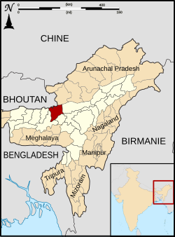
 Darrang district's location in Assam | |
| Country | |
| State | Assam |
| Headquarters | Mangaldoi |
| Population (2011) | |
| • Total | 9,08,090 |
| Time zone | UTC+05:30 (IST) |
| ISO 3166 code | IN-AS-DA |
| Website | http://darrang.gov.in/ |
Darrang (Pron: ˌdəˈræŋ or dæˈræŋ) (మూస:Lang-as) is an administrative district in the state of Assam in India. The district headquarters are located at Mangaldoi. The district occupies an area of 3481 km².
History
In 1983 Sonitpur district was formed from part of Darrang.[1] This was repeated on 14 June 2004 with the creation of Udalguri district.[1]
Geography
Darrang district occupies an area of 3,481 square kilometres (1,344 sq mi).[2]
National protected area
- Manas National Park (Part)
- Orang National Park(Part)
Divisions
There are four Assam Legislative Assembly constituencies in this district: Kalaigaon, Sipajhar, Mangaldoi, and Dalgaon.[3] Mangaldoi is designated for scheduled castes.[3] All four are in the Mangaldoi Lok Sabha constituency.[4]
2001 లో గణాంకాలు
| విషయాలు | వివరణలు |
|---|---|
| జిల్లా జనసంఖ్య . | 908,090,[5] |
| ఇది దాదాపు. | ఫిజి దేశ జనసంఖ్యకు సమానం.[6] |
| అమెరికాలోని. | డెలావర్ నగర జనసంఖ్యకు సమం.[7] |
| 640 భారతదేశ జిల్లాలలో. | 463 వ స్థానంలో ఉంది.[5] |
| 1చ.కి.మీ జనసాంద్రత. | 491 [5] |
| 2001-11 కుటుంబనియంత్రణ శాతం. | 19.51%.[5] |
| స్త్రీ పురుష నిష్పత్తి. | 923:1000 [5] |
| జాతియ సరాసరి (928) కంటే. | తక్కువ |
| అక్షరాశ్యత శాతం. | 64.55%.[5] |
| జాతియ సరాసరి (72%) కంటే. | తక్కువ |
| ముస్లిములు | 534,658 (35.54%) |
| హిందువులు | 868,532 (57.74%) |
| క్రైస్తవులు | 97,306 (1.75%) [8] |
Flora and fauna
In 1990 Darrang district became home to Manas National Park, which has an area of 500 km2 (193.1 sq mi).[9] It shares the park with four other districts. It is also home to Orang National Park, which it shares with Sonitpur district. Orang was established in 1999 and has an area of 79 km2 (30.5 sq mi).[9] Apart from the two national parks, it's also home to a wildlife sanctuary: the Barnodi.[9]
References
- ↑ 1.0 1.1 Law, Gwillim (2011-09-25). "Districts of India". Statoids. Retrieved 2011-10-11.
- ↑ Srivastava, Dayawanti et al. (ed.) (2010). "States and Union Territories: Assam: Government". India 2010: A Reference Annual (54th ed.). New Delhi, India: Additional Director General, Publications Division, Ministry of Information and Broadcasting (India), Government of India. p. 1116. ISBN 978-81-230-1617-7.
{{cite book}}:|access-date=requires|url=(help);|last1=has generic name (help) - ↑ 3.0 3.1 "List of Assembly Constituencies showing their Revenue & Election District wise break - up" (PDF). Chief Electoral Officer, Assam website. Retrieved 26 September 2011.
- ↑ "List of Assembly Constituencies showing their Parliamentary Constituencies wise break - up" (PDF). Chief Electoral Officer, Assam website. Retrieved 26 September 2011.
- ↑ 5.0 5.1 5.2 5.3 5.4 5.5 "District Census 2011". Census2011.co.in. 2011. Retrieved 2011-09-30.
- ↑ US Directorate of Intelligence. "Country Comparison:Population". Retrieved 2011-10-01.
Fiji 883,125 July 2011 est.
{{cite web}}: line feed character in|quote=at position 5 (help) - ↑ "2010 Resident Population Data". U. S. Census Bureau. Retrieved 2011-09-30.
Delaware 897,934
{{cite web}}: line feed character in|quote=at position 9 (help) - ↑ "Demographic Features of the District". Retrieved 2009-10-19.
- ↑ 9.0 9.1 9.2 Indian Ministry of Forests and Environment. "Protected areas: Assam". Retrieved September 25, 2011.