తూర్పు కనుమలు: కూర్పుల మధ్య తేడాలు
చి r2.7.2) (యంత్రము కలుపుతున్నది: vi:Ghat Đông |
SilvonenBot (చర్చ | రచనలు) చి r2.7.2) (యంత్రము మార్పులు చేస్తున్నది: ta:கிழக்குத் தொடர்ச்சி மலைகள் |
||
| పంక్తి 37: | పంక్తి 37: | ||
[[en:Eastern Ghats]] |
[[en:Eastern Ghats]] |
||
[[hi:पूर्वी घाट]] |
[[hi:पूर्वी घाट]] |
||
[[ta:கிழக்குத் தொடர்ச்சி |
[[ta:கிழக்குத் தொடர்ச்சி மலைகள்]] |
||
[[ml:പൂര്വ്വഘട്ടം]] |
[[ml:പൂര്വ്വഘട്ടം]] |
||
[[ca:Ghats Orientals]] |
[[ca:Ghats Orientals]] |
||
06:47, 18 ఆగస్టు 2012 నాటి కూర్పు
ఈ వ్యాసాన్ని పూర్తిగా అనువదించి, తరువాత ఈ మూసను తీసివేయండి. అనువాదం చేయాల్సిన వ్యాస భాగం ఒకవేళ ప్రధాన పేరుబరిలో వున్నట్లయితే పాఠ్యం సవరించు నొక్కినప్పుడు కనబడవచ్చు. అనువాదం పూర్తయినంతవరకు ఎర్రలింకులు లేకుండా చూడాలంటే ప్రస్తుత ఆంగ్ల కూర్పుని, భాషల లింకుల ద్వారా చూడండి(అనువాదకులకు వనరులు) |

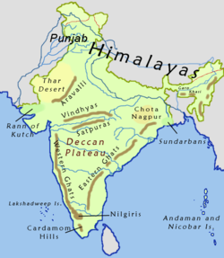
తూర్పు కనుమలు (ఆంగ్లం Eastern Ghats) భారత ద్వీపకల్పానికి తూర్పు సముద్ర తీరం వెంట ఉండే కొండల వరుస.
ఇవి ఉత్తరంగా పశ్చిమ బెంగాల్ నుండి, ఒరిస్సా, ఆంధ్ర ప్రదేశ్ ద్వారా దక్షిణంగా తమిళనాడు రాష్ట్రాలలోనికి వ్యాపించాయి. ఇవి గోదావరి, మహానది, కృష్ణా నది మరియు కావేరి నదుల ప్రవాహం వలన వేరుచేయబడ్డాయి. ఇవి బంగాళఖాతం సముద్రానికి సమాంతరంగా వ్యాపించాయి. వీని మధ్య ప్రదేశాన్ని కోస్తా ప్రాంతం అంటారు. దక్కను పీఠభూమి తూర్పు మరియు పడమర కనుమల మధ్యగా విస్తరించి ఉన్నది. పడమటి కనుమల కన్నా తూర్పు కనుమల ఎత్తు తక్కువగా ఉంటాయి.
దక్షిణ బాగాన తూర్పు కనుమలు విడిపొయి చిన్న చిన్న పర్వత శ్రేణులుగా విస్తరించి వుంటాయి. తూర్పు కనుమలు యొక్క దక్షిన చివరి భాగం తమిళనాడులొని సిరుమలై మరియు కరన్ తమలై అనె పర్వతశేణితొ ముగుస్తుంది. కావేరి నది ఉత్తరాన కొల్లి హిల్ల్స్ (కొల్లమలై), పంచమలై హిల్ల్స్ షెవరొయ్ హిల్ల్స్, సెర్వరొయన్,కల్ రాయన్ హిల్ల్స్,చిత్తేరి,పలమలై మరియు మెత్తుర్ హిల్ల్స్ అనె ఎత్తైన పర్వతాలు(తూర్పు కనుమలు) ఉత్తర తమిళనాడు లో విస్తరించి వున్నాయి. ఇక్కడ కొండలు పైన ఉష్ణోగ్రతలు చుట్టు ప్రక్కల ప్రదేశాల కంటే చల్లగాను తేమగాను వుంటాయి. ఈ ప్రదేశాలులొ కాఫీ తొటలు మరియు అడవులు ఉంటాయి. యార్కడ్ షెవరాయ్ కొండలలో ఉంది. The Bilgiri Hills, which run east from the Western Ghats to the Kaveri river, forms a forested ecological corridor that connects the Eastern and Western Ghats, and allows the second-largest wild elephant population in India to range between the South Eastern Ghats, the Biligiri and Nilgiri hills, and the South Western Ghats.

The Ponnaiyar and Palar rivers flow from headwaters on the Kolar Plateau eastward through gaps in the Ghats to empty into the Bay of Bengal; the Javadhu Hills lie between the two rivers. There are waterfalls in remote areas, such as the Kiliyur Falls.[1]
North of the Palar River in Andhra Pradesh, the central portion of the Eastern Ghats consist of two parallel ranges running approximately north-south; the lower Velikonda Range lies to the east, and the higher Palikonda-Lankamalla-Nallamalla ranges lie to the west. The Palar River cuts through the ranges. The Velikonda range eventually descends to the coastal plain in northern Nellore district, while the Nallamalla range continues to the Krishna River. A range of low hills lie between the Krishna and the గోదావరి, గోదావరి నది యొక్క ఉత్తర బాగాన తూర్పు కనుమలు ఎత్తుగా ఉంటాయి , forming the boundary between Andhra Pradesh and Orissa. ఈ ప్రాంతం అంత సారవంతమైన భూమి కలిగి ఉంది. పశ్చమ కనుమలలో లాగ ఇక్కడ జలవిద్యుఛ్చక్తి కి అనువైనది కాదు.
The Eastern Ghats are older than the Western Ghats, and have a complex geologic history, related to the assembly and breakup of the ancient supercontinent of Rodinia and the assembly of the Gondwana supercontinent.
ఇవి కూడా చూడండి
మూలాలు
- ↑ "Jungle Look". The Hindu. Retrieved 2006-12-09.