దస్త్రం:ElectoralCollege1980.svg
Jump to navigation
Jump to search

ఈ ఫైలు SVG కు చెందిన ఈ మునుజూపు PNG పరిమాణం: 800 × 465 పిక్సెళ్ళు. ఇతర రిజల్యూషన్లు: 320 × 186 పిక్సెళ్ళు | 640 × 372 పిక్సెళ్ళు | 1,024 × 595 పిక్సెళ్ళు | 1,280 × 744 పిక్సెళ్ళు | 2,560 × 1,488 పిక్సెళ్ళు | 1,020 × 593 పిక్సెళ్ళు.
అసలు దస్త్రం (SVG ఫైలు, నామమాత్రంగా 1,020 × 593 పిక్సెళ్ళు, ఫైలు పరిమాణం: 28 KB)
This is a file from the Wikimedia Commons. Information from its description page there is shown below. Commons is a freely licensed media file repository. You can help. |
సారాంశం
| వివరణ |
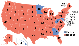
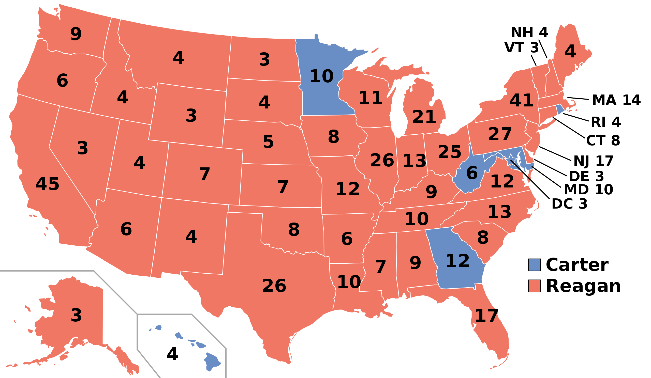
English: Electoral College results map for the 1980 United States presidential election between Ronald Reagan and Jimmy Carter based on: https://www.archives.gov/electoral-college/1980 |
| తేదీ | |
| మూలం | స్వంత కృతి |
| కర్త | SteveSims~commonswiki |
| U.S. presidential election maps (SVG) |
| See also: National Atlas maps (png) |
|
1789 · 1792 · 1796 · 1800 · 1804 · 1808 · 1812 · 1816 · 1820 · 1824 · 1828 · 1832 · 1836 · 1840 · 1844 · 1848 · 1852 · 1856 · 1860 · 1864 · 1868 · 1872 · 1876 · 1880 · 1884 · 1888 · 1892 · 1896 · 1900 · 1904 · 1908 · 1912 · 1916 · 1920 · 1924 · 1928 · 1932 · 1936 · 1940 · 1944 · 1948 · 1952 · 1956 · 1960 · 1964 · 1968 · 1972 · 1976 · 1980 · 1984 · 1988 · 1992 · 1996 · 2000 · 2004 · 2008 · 2012 · 2016 · 2020 · 2024 |
లైసెన్సింగ్
| నేను, ఈ కృతి యొక్క కాపీహక్కుదారుని, ఈ కృతిని సార్వజనీనం'గా విడుదల చేస్తున్నాను. ఇది ప్రపంచవ్యాప్తంగా వర్తిస్తుంది. కొన్ని దేశాల్లో ఇది చట్టబద్ధంగా సాధ్యంకాకపోవచ్చు; అయితే: ఈ కృతిని ఎటువంటి షరతులు లేకుండా, అట్టి షరతులు చట్టం వల్ల తప్పనిసరి అయితే తప్ప, ఏ ఉద్దేశానికైనా ఉపయోగించుకునే హక్కును ఎవరికైనా నేను ప్రదానం చేస్తున్నాను. |
ఫైలు చరితం
తేదీ/సమయం ను నొక్కి ఆ సమయాన ఫైలు ఎలా ఉండేదో చూడవచ్చు.
| తేదీ/సమయం | నఖచిత్రం | కొలతలు | వాడుకరి | వ్యాఖ్య | |
|---|---|---|---|---|---|
| ప్రస్తుత | 12:56, 28 డిసెంబరు 2018 | | 1,020 × 593 (28 KB) | Newfraferz87 | Optimize |
| 11:43, 6 ఫిబ్రవరి 2017 |  | 1,020 × 593 (34 KB) | Newfraferz87 | Clearer state borders | |
| 23:31, 13 నవంబరు 2016 |  | 1,020 × 593 (44 KB) | Wow | Space between MA and 14 | |
| 21:39, 13 నవంబరు 2016 |  | 1,020 × 593 (43 KB) | Wow | One last change | |
| 21:38, 13 నవంబరు 2016 |  | 1,020 × 593 (43 KB) | Wow | Removed line and changed DC | |
| 02:15, 12 నవంబరు 2016 |  | 1,020 × 593 (119 KB) | Tony Patt | Reverted to version as of 02:06, 23 June 2008 (UTC) : disproportionate when used with image map | |
| 11:30, 18 నవంబరు 2011 |  | 1,004 × 588 (91 KB) | Citypeek | removal line | |
| 02:06, 23 జూన్ 2008 |  | 1,020 × 593 (119 KB) | SteveSims~commonswiki | Washington fixed | |
| 21:52, 21 జూన్ 2008 |  | 1,020 × 593 (119 KB) | SteveSims~commonswiki | Correct electoral college numbers. | |
| 22:54, 14 జూన్ 2008 |  | 1,020 × 593 (119 KB) | SteveSims~commonswiki | == Summary == I created this image based on this map from the WikiMedia Commons: http://commons.wikimedia.org/wiki/Image:Blank_US_Map.svg It is in the public domain. == Licensing == {{PD-self}} |
లింకులు
కింది పేజీలలో ఈ ఫైలుకు లింకులు ఉన్నాయి:
సార్వత్రిక ఫైలు వాడుక
ఈ దస్త్రాన్ని ఈ క్రింది ఇతర వికీలు ఉపయోగిస్తున్నాయి:
- ast.wikipedia.org లో వాడుక
- az.wikipedia.org లో వాడుక
- bg.wikipedia.org లో వాడుక
- ca.wikipedia.org లో వాడుక
- da.wikipedia.org లో వాడుక
- de.wikipedia.org లో వాడుక
- el.wikipedia.org లో వాడుక
- en.wikipedia.org లో వాడుక
- George H. W. Bush
- Jimmy Carter
- Ronald Reagan
- 1980 United States presidential election
- Presidency of Ronald Reagan
- Electoral vote changes between United States presidential elections
- List of United States presidential election results by state
- Presidency of Jimmy Carter
- 1980 United States presidential election in Missouri
- Electoral history of George H. W. Bush
- Electoral history of Ronald Reagan
- 1980 United States elections
- 1980 United States presidential election in California
- Ronald Reagan 1980 presidential campaign
- United States presidential election
- 1980 United States presidential election in Florida
- 1980 United States presidential election in North Carolina
- 1980 United States presidential election in Pennsylvania
- Portal:Conservatism/Selected anniversary
- Portal:Conservatism/Selected anniversary/November
- 1980 United States presidential election in Montana
- Template:State results of the 1980 U.S. presidential election
- 1980 United States presidential election in Maryland
- Template:1980 United States presidential election imagemap
- 1980 United States presidential election in Vermont
- 1980 United States presidential election in New Mexico
- 1980 United States presidential election in New York
- 1980 United States presidential election in Massachusetts
- 1980 United States presidential election in Alaska
- 1980 United States presidential election in New Jersey
- 1980 United States presidential election in Texas
- 1980 United States presidential election in Alabama
- 1980 United States presidential election in Minnesota
- 1980 United States presidential election in Utah
- 1980 United States presidential election in New Hampshire
- 1980 United States presidential election in Virginia
- 1980 United States presidential election in Connecticut
- 1980 United States presidential election in Delaware
- 1980 United States presidential election in Ohio
- 1980 United States presidential election in Hawaii
ఈ దస్త్రపు మరింత సార్వత్రిక వాడుకను చూడండి.