దస్త్రం:Karte Adelaide MKL1888.png
Jump to navigation
Jump to search
మరింత స్పష్టమైన బొమ్మ లేదు.
Karte_Adelaide_MKL1888.png (365 × 539 పిక్సెళ్ళు, ఫైలు పరిమాణం: 51 KB, MIME రకం: image/png)
This is a file from the Wikimedia Commons. Information from its description page there is shown below. Commons is a freely licensed media file repository. You can help. |
సారాంశం
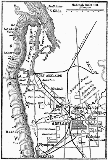
| వివరణ |
Deutsch: Plan von Adelaide (1 : 320.000)
English: Map of Adelaide (1:320,000 scale) |
| తేదీ | circa 1885 |
| మూలం | |
| కర్త | Unknown author |

లైసెన్సింగ్
| This image comes from the 4th edition of Meyers Konversationslexikon (1885–90). The copyrights have expired and this image is in the public domain. |
|
This work is in the public domain in its country of origin and other countries and areas where the copyright term is the author's life plus 100 years or fewer. This work is in the public domain in the United States because it was published (or registered with the U.S. Copyright Office) before January 1, 1929. | |
| This file has been identified as being free of known restrictions under copyright law, including all related and neighboring rights. | |
ఫైలు చరితం
తేదీ/సమయం ను నొక్కి ఆ సమయాన ఫైలు ఎలా ఉండేదో చూడవచ్చు.
| తేదీ/సమయం | నఖచిత్రం | కొలతలు | వాడుకరి | వ్యాఖ్య | |
|---|---|---|---|---|---|
| ప్రస్తుత | 17:33, 11 డిసెంబరు 2004 | | 365 × 539 (51 KB) | ¡0-8-15! | {{Template:PD-Meyers}} |
లింకులు
ఈ ఫైలును వాడుతున్న పేజీలు లేవు.
సార్వత్రిక ఫైలు వాడుక
ఈ దస్త్రాన్ని ఈ క్రింది ఇతర వికీలు ఉపయోగిస్తున్నాయి:
- ckb.wikipedia.org లో వాడుక
- da.wikipedia.org లో వాడుక
- de.wikipedia.org లో వాడుక
- de.wikisource.org లో వాడుక
- en.wikipedia.org లో వాడుక
- fa.wikipedia.org లో వాడుక
- fi.wikipedia.org లో వాడుక
- lb.wikipedia.org లో వాడుక
- ms.wikipedia.org లో వాడుక
- zh.wikipedia.org లో వాడుక