దస్త్రం:King Fahd causeway satellite.png
Jump to navigation
Jump to search

ఈ మునుజూపు పరిమాణం: 800 × 527 పిక్సెళ్ళు. ఇతర రిజల్యూషన్లు: 320 × 211 పిక్సెళ్ళు | 640 × 422 పిక్సెళ్ళు | 992 × 654 పిక్సెళ్ళు.
అసలు దస్త్రం (992 × 654 పిక్సెళ్ళు, ఫైలు పరిమాణం: 900 KB, MIME రకం: image/png)
This is a file from the Wikimedia Commons. Information from its description page there is shown below. Commons is a freely licensed media file repository. You can help. |
సారాంశం
| వివరణ |
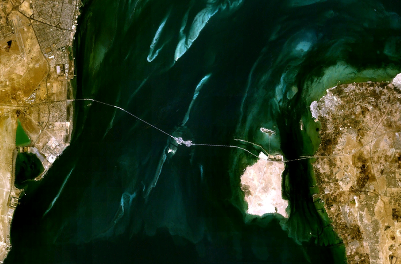
English: Satellite image of the King Fahd Causeway, linking Saudi Arabia (left) and Bahrain (right). |
| తేదీ | 21 మార్చి 2006 (original upload date) |
| మూలం | NASA World Wind |
| కర్త | Roke (original uploader) |
లైసెన్సింగ్
| This image is in the public domain because it is a screenshot from NASA’s globe software World Wind using a public domain layer, such as Blue Marble, MODIS, Landsat, SRTM, USGS or GLOBE.
|
 |
ఫైలు చరితం
తేదీ/సమయం ను నొక్కి ఆ సమయాన ఫైలు ఎలా ఉండేదో చూడవచ్చు.
| తేదీ/సమయం | నఖచిత్రం | కొలతలు | వాడుకరి | వ్యాఖ్య | |
|---|---|---|---|---|---|
| ప్రస్తుత | 03:49, 21 మార్చి 2006 | | 992 × 654 (900 KB) | Roke~commonswiki | satellite image of the king fahd causeway linking saudi arabia (left) with barhrain (right) {{PD-WorldWind}} Category: Bahrain |
లింకులు
కింది పేజీలలో ఈ ఫైలుకు లింకులు ఉన్నాయి:
సార్వత్రిక ఫైలు వాడుక
ఈ దస్త్రాన్ని ఈ క్రింది ఇతర వికీలు ఉపయోగిస్తున్నాయి:
- ar.wikipedia.org లో వాడుక
- az.wikipedia.org లో వాడుక
- be.wikipedia.org లో వాడుక
- bg.wikipedia.org లో వాడుక
- bn.wikipedia.org లో వాడుక
- ceb.wikipedia.org లో వాడుక
- cs.wikipedia.org లో వాడుక
- da.wikipedia.org లో వాడుక
- de.wikipedia.org లో వాడుక
- de.wikivoyage.org లో వాడుక
- en.wikipedia.org లో వాడుక
- eo.wikipedia.org లో వాడుక
- es.wikipedia.org లో వాడుక
- eu.wikipedia.org లో వాడుక
- fa.wikipedia.org లో వాడుక
- fr.wikipedia.org లో వాడుక
- gl.wikipedia.org లో వాడుక
- he.wikipedia.org లో వాడుక
- hr.wikipedia.org లో వాడుక
- hy.wikipedia.org లో వాడుక
- id.wikipedia.org లో వాడుక
- it.wikipedia.org లో వాడుక
- ja.wikipedia.org లో వాడుక
- ko.wikipedia.org లో వాడుక
- krc.wikipedia.org లో వాడుక
- lt.wikipedia.org లో వాడుక
- ml.wikipedia.org లో వాడుక
- nds.wikipedia.org లో వాడుక
- nl.wikipedia.org లో వాడుక
ఈ దస్త్రపు మరింత సార్వత్రిక వాడుకను చూడండి.