దస్త్రం:Lop Nur, Xinjiang, China.jpg
Jump to navigation
Jump to search

ఈ మునుజూపు పరిమాణం: 588 × 600 పిక్సెళ్ళు. ఇతర రిజల్యూషన్లు: 235 × 240 పిక్సెళ్ళు | 470 × 480 పిక్సెళ్ళు | 753 × 768 పిక్సెళ్ళు | 1,004 × 1,024 పిక్సెళ్ళు | 2,366 × 2,414 పిక్సెళ్ళు.
అసలు దస్త్రం (2,366 × 2,414 పిక్సెళ్ళు, ఫైలు పరిమాణం: 372 KB, MIME రకం: image/jpeg)
This is a file from the Wikimedia Commons. Information from its description page there is shown below. Commons is a freely licensed media file repository. You can help. |
సారాంశం
| వివరణ |
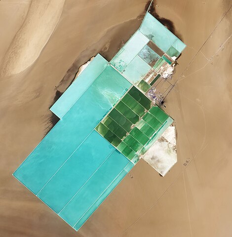
English: Natural-colour image of Lop Nur. The rectangular shapes in this image show the bright colours characteristic of solar evaporation ponds. Around the evaporation ponds are the earth tones typical of sandy desert. |
|||||
| తేదీ | ||||||
| మూలం | NASA Earth Observatory | |||||
| కర్త | Jesse Allen and Robert Simmon | |||||
| అనుమతి (ఈ దస్త్రాన్ని పునర్వినియోగించుకోవడం) |
|

| Camera location | | View this and other nearby images on: OpenStreetMap |
|---|
Image captured by the Advanced Land Imager (ALI) on NASA’s Earth Observing-1 (EO-1) satellite. EO-1 ALI data provided courtesy of the NASA EO-1 team.
ఫైలు చరితం
తేదీ/సమయం ను నొక్కి ఆ సమయాన ఫైలు ఎలా ఉండేదో చూడవచ్చు.
| తేదీ/సమయం | నఖచిత్రం | కొలతలు | వాడుకరి | వ్యాఖ్య | |
|---|---|---|---|---|---|
| ప్రస్తుత | 10:07, 20 జూన్ 2011 | | 2,366 × 2,414 (372 KB) | Originalwana | {{Information |Description ={{en|1=Natural-colour image of Lop Nur. The rectangular shapes in this image show the bright colours characteristic of solar evaporation ponds. Around the evaporation ponds are the earth tones typical of sandy desert. }} |
లింకులు
కింది పేజీలలో ఈ ఫైలుకు లింకులు ఉన్నాయి:
సార్వత్రిక ఫైలు వాడుక
ఈ దస్త్రాన్ని ఈ క్రింది ఇతర వికీలు ఉపయోగిస్తున్నాయి:
- ro.wikipedia.org లో వాడుక
- sl.wikipedia.org లో వాడుక
- zh.wikipedia.org లో వాడుక