దస్త్రం:Map India and Pakistan 1-250,000 Tile NI 43-4 Chulung.jpg
Jump to navigation
Jump to search

ఈ మునుజూపు పరిమాణం: 791 × 600 పిక్సెళ్ళు. ఇతర రిజల్యూషన్లు: 317 × 240 పిక్సెళ్ళు | 633 × 480 పిక్సెళ్ళు | 1,013 × 768 పిక్సెళ్ళు | 1,280 × 970 పిక్సెళ్ళు | 2,560 × 1,941 పిక్సెళ్ళు | 5,000 × 3,791 పిక్సెళ్ళు.
అసలు దస్త్రం (5,000 × 3,791 పిక్సెళ్ళు, ఫైలు పరిమాణం: 3.62 MB, MIME రకం: image/jpeg)
This is a file from the Wikimedia Commons. Information from its description page there is shown below. Commons is a freely licensed media file repository. You can help. |
| Description |
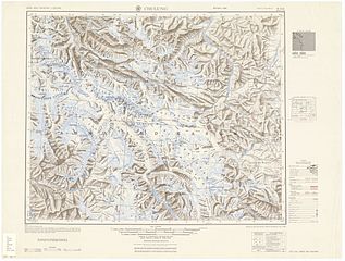
English: NI 43-4 Chulung. Tile of the Map India and Pakistan 1:250,000. Series U502, U.S. Army Map Service, 1955 |
||||||
| తేదీ | |||||||
| మూలం | https://www.lib.utexas.edu/maps/ams/india/ [1] | ||||||
| స్రష్ట |
English: U.S. Army Map Service |
||||||
| అనుమతి (ఈ దస్త్రాన్ని పునర్వినియోగించుకోవడం) |
|
||||||
| Georeferencing | If inappropriate please set warp_status = skip to hide. | ||||||
| ఇతర కూర్పులు |
|
||||||

.jpg)

![[1]](http://www.lib.utexas.edu/maps/ams/india/ni-43-04.jpg)
| Annotations | This image is annotated: View the annotations at Commons |
ఫైలు చరితం
తేదీ/సమయం ను నొక్కి ఆ సమయాన ఫైలు ఎలా ఉండేదో చూడవచ్చు.
| తేదీ/సమయం | నఖచిత్రం | కొలతలు | వాడుకరి | వ్యాఖ్య | |
|---|---|---|---|---|---|
| ప్రస్తుత | 19:02, 11 సెప్టెంబరు 2012 | | 5,000 × 3,791 (3.62 MB) | Slick-o-bot | {{Information |Description={{en|1=NI 43-4 Chulung. Tile of the Map India and Pakistan 1:250,000. Series U502, U.S. Army Map Service, 1955}} |Source=https://www.lib.utexas.edu/maps/ams/india/ [http://www.lib.utexas.edu/maps/ams/india/ni-43-04.jpg] |Date... |
లింకులు
కింది పేజీలలో ఈ ఫైలుకు లింకులు ఉన్నాయి:
సార్వత్రిక ఫైలు వాడుక
ఈ దస్త్రాన్ని ఈ క్రింది ఇతర వికీలు ఉపయోగిస్తున్నాయి:
- bn.wikipedia.org లో వాడుక
- ca.wikipedia.org లో వాడుక
- en.wikipedia.org లో వాడుక
- en.wiktionary.org లో వాడుక
- fr.wikipedia.org లో వాడుక
- id.wikipedia.org లో వాడుక