దస్త్రం:Map of the Canary Islands.svg
Jump to navigation
Jump to search

ఈ ఫైలు SVG కు చెందిన ఈ మునుజూపు PNG పరిమాణం: 800 × 355 పిక్సెళ్ళు. ఇతర రిజల్యూషన్లు: 320 × 142 పిక్సెళ్ళు | 640 × 284 పిక్సెళ్ళు | 1,024 × 455 పిక్సెళ్ళు | 1,280 × 569 పిక్సెళ్ళు | 2,560 × 1,137 పిక్సెళ్ళు | 3,152 × 1,400 పిక్సెళ్ళు.
అసలు దస్త్రం (SVG ఫైలు, నామమాత్రంగా 3,152 × 1,400 పిక్సెళ్ళు, ఫైలు పరిమాణం: 835 KB)
This is a file from the Wikimedia Commons. Information from its description page there is shown below. Commons is a freely licensed media file repository. You can help. |
సారాంశం
| వివరణ |
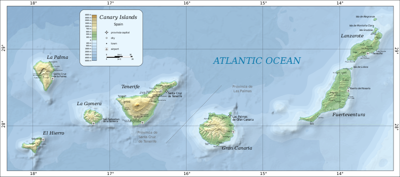
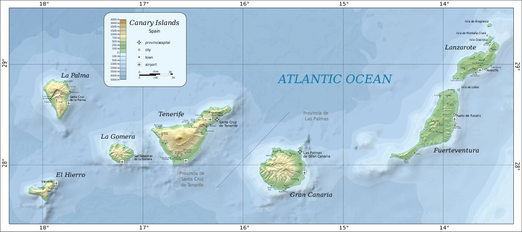
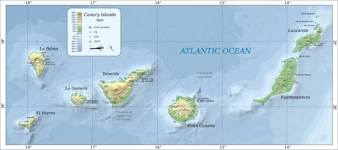
Deutsch: Karte der Kanarischen Inseln auf Englisch English: Map of the Canary Islands. Magyar: A Kanári-szigetek térképe Română: Harta Insulelor Canare. |
| తేదీ | |
| మూలం | Self-made in Inkscape by w:User:Mysid. Based on SRTM data as edited by CGIAR-CSI. Place names based on the Open Streetmap. |
| కర్త | Oona Räisänen (Mysid) |
| ఇతర కూర్పులు |
|


లైసెన్సింగ్
| ఈ కృతిని కృతికర్త, Mysid at ఇంగ్లీష్ వికీపీడియా', సార్వజనీనంగా విడుదల చేసారు. ఇది ప్రపంచవ్యాప్తంగా వర్తిస్తుంది. కొన్ని దేశాల్లో ఇది చట్టబద్ధంగా సాధ్యంకాకపోవచ్చు; అయితే: ఈ కృతిని ఎటువంటి షరతులు లేకుండా, అట్టి షరతులు చట్టం వల్ల తప్పనిసరి అయితే తప్ప, ఏ ఉద్దేశానికైనా ఉపయోగించుకునే హక్కును ఎవరికైనా Mysid ప్రదానం చేస్తున్నారు. |

|
This SVG file contains embedded text that can be translated into your language, using any capable SVG editor, text editor or the SVG Translate tool. For more information see: About translating SVG files. |
ఫైలు చరితం
తేదీ/సమయం ను నొక్కి ఆ సమయాన ఫైలు ఎలా ఉండేదో చూడవచ్చు.
| తేదీ/సమయం | నఖచిత్రం | కొలతలు | వాడుకరి | వ్యాఖ్య | |
|---|---|---|---|---|---|
| ప్రస్తుత | 14:57, 26 జూన్ 2020 | | 3,152 × 1,400 (835 KB) | Gaja | fixed and supplemented place names, some error correction |
| 23:31, 9 ఆగస్టు 2010 |  | 3,152 × 1,400 (828 KB) | Mysid | bathymetry experiment | |
| 17:00, 5 ఆగస్టు 2010 |  | 3,152 × 1,400 (736 KB) | Mysid | fonts | |
| 16:56, 5 ఆగస్టు 2010 |  | 3,152 × 1,400 (733 KB) | Mysid | updated with better data sources | |
| 21:49, 21 జనవరి 2009 |  | 776 × 399 (274 KB) | Mysid | revised fonts | |
| 20:59, 16 జనవరి 2009 |  | 776 × 399 (274 KB) | Mysid | resizing embedded png | |
| 13:13, 5 జనవరి 2009 |  | 776 × 399 (225 KB) | Mysid | major improvements | |
| 23:16, 1 ఆగస్టు 2007 |  | 734 × 355 (27 KB) | Mysid | {{Information |Description=Map of the Canary Islands. |Source=SVG drawn in Inkscape by Mysid; based on a JPEG (en:Image:Canary-map.jpg) originally compiled from a NASA source by Montrealais. |Date=August 2, 2007 |Author= [[w: |
లింకులు
కింది పేజీలలో ఈ ఫైలుకు లింకులు ఉన్నాయి:
సార్వత్రిక ఫైలు వాడుక
ఈ దస్త్రాన్ని ఈ క్రింది ఇతర వికీలు ఉపయోగిస్తున్నాయి:
- ar.wikipedia.org లో వాడుక
- ast.wikipedia.org లో వాడుక
- az.wikipedia.org లో వాడుక
- be-tarask.wikipedia.org లో వాడుక
- bg.wikipedia.org లో వాడుక
- bn.wikipedia.org లో వాడుక
- cs.wikipedia.org లో వాడుక
- da.wikipedia.org లో వాడుక
- de.wikipedia.org లో వాడుక
- de.wikivoyage.org లో వాడుక
- el.wikipedia.org లో వాడుక
- el.wikivoyage.org లో వాడుక
- en.wikipedia.org లో వాడుక
- es.wikipedia.org లో వాడుక
- eu.wikipedia.org లో వాడుక
- fi.wikipedia.org లో వాడుక
- fr.wikipedia.org లో వాడుక
- fy.wikipedia.org లో వాడుక
- id.wikipedia.org లో వాడుక
- is.wikipedia.org లో వాడుక
- it.wikivoyage.org లో వాడుక
- kbd.wikipedia.org లో వాడుక
- lb.wikipedia.org లో వాడుక
- lt.wikipedia.org లో వాడుక
- mn.wikipedia.org లో వాడుక
- nl.wikipedia.org లో వాడుక
- nn.wikipedia.org లో వాడుక
- no.wikipedia.org లో వాడుక
- pl.wikipedia.org లో వాడుక
- pl.wikivoyage.org లో వాడుక
- ru.wikipedia.org లో వాడుక
- sc.wikipedia.org లో వాడుక
- sv.wikivoyage.org లో వాడుక
- tt.wikipedia.org లో వాడుక
- uk.wikipedia.org లో వాడుక
- uk.wikivoyage.org లో వాడుక
- vi.wikivoyage.org లో వాడుక
ఈ దస్త్రపు మరింత సార్వత్రిక వాడుకను చూడండి.