దస్త్రం:Partition of India.PNG
Jump to navigation
Jump to search

మరింత స్పష్టమైన బొమ్మ లేదు.
Partition_of_India.PNG (450 × 400 పిక్సెళ్ళు, ఫైలు పరిమాణం: 27 KB, MIME రకం: image/png)
This is a file from the Wikimedia Commons. Information from its description page there is shown below. Commons is a freely licensed media file repository. You can help. |

|
This historical map image could be re-created using vector graphics as an SVG file. This has several advantages; see Commons:Media for cleanup for more information. If an SVG form of this image is available, please upload it and afterwards replace this template with
{{vector version available|new image name}}.
It is recommended to name the SVG file “Partition of India.svg”—then the template Vector version available (or Vva) does not need the new image name parameter. |

|
This map has been uploaded by Electionworld from en.wikipedia.org to enable the |
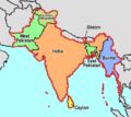
Map showing the Partition of India, by McMullen
| నేను, ఈ కృతి యొక్క కాపీహక్కుదారుని, ఈ కృతిని సార్వజనీనం'గా విడుదల చేస్తున్నాను. ఇది ప్రపంచవ్యాప్తంగా వర్తిస్తుంది. కొన్ని దేశాల్లో ఇది చట్టబద్ధంగా సాధ్యంకాకపోవచ్చు; అయితే: ఈ కృతిని ఎటువంటి షరతులు లేకుండా, అట్టి షరతులు చట్టం వల్ల తప్పనిసరి అయితే తప్ప, ఏ ఉద్దేశానికైనా ఉపయోగించుకునే హక్కును ఎవరికైనా నేను ప్రదానం చేస్తున్నాను. |
[]
-
 English
 -
 English
 -
 Esperanto
 -
 español
 -
 français
 -
 italiano
 -
 magyar
 -
 Bahasa Melayu
 -
 polski
 -
 нохчийн
 -
 русский
 -
 मराठी
मराठी -
 हिन्दी
 -
 বাংলা
বাংলা -
 বাংলা
বাংলা -
 ਪੰਜਾਬੀ
 -
 ગુજરાતી
 -
 ಕನ್ನಡ
ಕನ್ನಡ -
 עברית
עברית -
 سنڌي
سنڌي -
 اردو
اردو -
 العربية
 -
 فارسی
فارسی


.svg)


ఫైలు చరితం
తేదీ/సమయం ను నొక్కి ఆ సమయాన ఫైలు ఎలా ఉండేదో చూడవచ్చు.
| తేదీ/సమయం | నఖచిత్రం | కొలతలు | వాడుకరి | వ్యాఖ్య | |
|---|---|---|---|---|---|
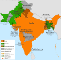
| ప్రస్తుత | 06:58, 20 నవంబరు 2018 | | 450 × 400 (27 KB) | ARR8 | |
| 22:51, 13 డిసెంబరు 2006 |  | 450 × 400 (19 KB) | Electionworld | {{ew|en|McMullen}} Map showing the Partition of India, by McMullen {{PD-self}} |
లింకులు
కింది పేజీలలో ఈ ఫైలుకు లింకులు ఉన్నాయి:
సార్వత్రిక ఫైలు వాడుక
ఈ దస్త్రాన్ని ఈ క్రింది ఇతర వికీలు ఉపయోగిస్తున్నాయి:
- anp.wikipedia.org లో వాడుక
- ar.wikipedia.org లో వాడుక
- ast.wikipedia.org లో వాడుక
- ca.wikipedia.org లో వాడుక
- ckb.wikipedia.org లో వాడుక
- el.wikipedia.org లో వాడుక
- en.wikipedia.org లో వాడుక
- en.wikivoyage.org లో వాడుక
- es.wikipedia.org లో వాడుక
- et.wikipedia.org లో వాడుక
- gu.wikipedia.org లో వాడుక
- hr.wikipedia.org లో వాడుక
- id.wikipedia.org లో వాడుక
- io.wikipedia.org లో వాడుక
- ja.wikipedia.org లో వాడుక
- ka.wikipedia.org లో వాడుక
- nl.wikipedia.org లో వాడుక
- ru.wikipedia.org లో వాడుక
- sh.wikipedia.org లో వాడుక
- sq.wikipedia.org లో వాడుక
- sr.wikipedia.org లో వాడుక
- ta.wikiquote.org లో వాడుక
- uk.wikipedia.org లో వాడుక
- www.wikidata.org లో వాడుక
- zh-yue.wikipedia.org లో వాడుక
- zh.wikipedia.org లో వాడుక