దస్త్రం:Race and ethnicity 2010- Houston.png
Jump to navigation
Jump to search

ఈ మునుజూపు పరిమాణం: 600 × 600 పిక్సెళ్ళు. ఇతర రిజల్యూషన్లు: 240 × 240 పిక్సెళ్ళు | 480 × 480 పిక్సెళ్ళు | 768 × 768 పిక్సెళ్ళు | 1,024 × 1,024 పిక్సెళ్ళు | 2,048 × 2,048 పిక్సెళ్ళు | 3,009 × 3,009 పిక్సెళ్ళు.
అసలు దస్త్రం (3,009 × 3,009 పిక్సెళ్ళు, ఫైలు పరిమాణం: 2.44 MB, MIME రకం: image/png)
This is a file from the Wikimedia Commons. Information from its description page there is shown below. Commons is a freely licensed media file repository. You can help. |
సారాంశం
| వివరణ |
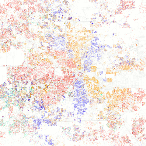
English: Maps of racial and ethnic divisions in US cities, inspired by Bill Rankin's map of Chicago, updated for Census 2010.
Red is White, Blue is Black, Green is Asian, Orange is Hispanic, Yellow is Other, and each dot is 25 residents. Data from Census 2010. Base map © OpenStreetMap, CC-BY-SA |
| తేదీ | |
| మూలం | Race and ethnicity 2010: Houston |
| కర్త | Erica Fischer |
| Camera location | | View this and other nearby images on: OpenStreetMap |
|---|
లైసెన్సింగ్
ఈ దస్త్రం క్రియేటివ్ కామన్స్ ఆపాదింపు-యథాతథ పంచుకోలు 2.0 సాధారణం లైసెన్సు క్రింద లభ్యం.
- ఇలా చేసేందుకు మీకు స్వేచ్ఛ ఉంది:
- పంచుకోడానికి – ఈ కృతిని కాపీ చేసుకోవచ్చు, పంపిణీ చేయవచ్చు, ప్రసారమూ చేయవచ్చు
- రీమిక్స్ చేయడానికి – కృతిని అనుకరించడానికి
- క్రింది షరతులకు లోబడి:
- ఆపాదింపు – సముచితమైన శ్రేయస్సును ఇవ్వాలి, లైసెన్సుకు లింకు ఇవ్వాలి, మార్పులేమైనా చేస్తే వాటిని సూచించాలి. అందుకు సముచితమైన పద్ధతి దేన్నైనా అవలంబించవచ్చు. కానీ మీకూ మీ వాడుకకూ హక్కుదారు అనుమతించారు అనే అర్థం వచ్చేటట్లుగా మాత్రం కాదు.
- share alike – మీరు ఈ కృతిని అనుకరిస్తే, మారిస్తే, లేదా మెరుగుపరిస్తే తత్ఫలిత కృతిని ఇదే లైసెన్సు లేదా దీనికి అనుగుణ్యమైన లైసెన్సు క్రింద మాత్రమే పంపిణీ చేయాలి.
| This image was originally posted to Flickr by Eric Fischer at https://www.flickr.com/photos/24431382@N03/5560487046. It was reviewed on 18 సెప్టెంబరు 2011 by FlickreviewR and was confirmed to be licensed under the terms of the cc-by-sa-2.0. |
ఫైలు చరితం
తేదీ/సమయం ను నొక్కి ఆ సమయాన ఫైలు ఎలా ఉండేదో చూడవచ్చు.
| తేదీ/సమయం | నఖచిత్రం | కొలతలు | వాడుకరి | వ్యాఖ్య | |
|---|---|---|---|---|---|
| ప్రస్తుత | 20:43, 9 మార్చి 2013 | | 3,009 × 3,009 (2.44 MB) | JohnnyMrNinja | indexed colors and increased compression |
| 07:27, 18 సెప్టెంబరు 2011 |  | 3,009 × 3,009 (6.25 MB) | WhisperToMe | {{Information |Description={{en|Maps of racial and ethnic divisions in US cities, inspired by [http://www.radicalcartography.net/index.html?chicagodots Bill Rankin's map of Chicago], updated for Census 2010. Red is White, Blue is Black, Green is Asian, O |
లింకులు
కింది పేజీలలో ఈ ఫైలుకు లింకులు ఉన్నాయి:
సార్వత్రిక ఫైలు వాడుక
ఈ దస్త్రాన్ని ఈ క్రింది ఇతర వికీలు ఉపయోగిస్తున్నాయి:
- bg.wikipedia.org లో వాడుక
- en.wikipedia.org లో వాడుక
- en.wikibooks.org లో వాడుక
- he.wikipedia.org లో వాడుక
- he.wikivoyage.org లో వాడుక
- pl.wikipedia.org లో వాడుక
- ru.wikipedia.org లో వాడుక
- sk.wikipedia.org లో వాడుక