దస్త్రం:Roman Empire map.gif
Jump to navigation
Jump to search

ఈ మునుజూపు పరిమాణం: 631 × 599 పిక్సెళ్ళు. ఇతర రిజల్యూషన్లు: 253 × 240 పిక్సెళ్ళు | 505 × 480 పిక్సెళ్ళు.
అసలు దస్త్రం (800 × 760 పిక్సెళ్ళు, ఫైలు పరిమాణం: 95 KB, MIME రకం: image/gif, లూపులో పడింది, 38 ఫ్రేములు, 1 నిమి 7క్ష)
This is a file from the Wikimedia Commons. Information from its description page there is shown below. Commons is a freely licensed media file repository. You can help. |
{{Superseded|Roman Empire map.ogv|Video to avoid the "animated gifs exceeding the 12.5MP limit", and useful to stop
సారాంశం
| వివరణ |
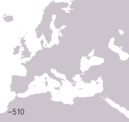
English: This is an animated map showing the territorial evolution of the Roman Republic and then the Roman Empire. Years shown: 510BC, 320BC, 300BC, 270BC, 220BC, 190BC, 140BC, 70BC, 40BC, 20AD, 70AD, 140AD, 230AD, 300AD, 360AD, 405AD, 420AD, 450AD, 480AD, 530AD, 560AD, 600AD, 630AD, 650AD, 740AD, 867AD, 1025AD, 1095AD, 1170AD, 1200AD, 1204AD, 1280AD, 1360AD, 1400AD, 1430AD, 1453AD Français : Carte de l'évolution territoriale de l'Empire romain. Années affichées : -510, -320, -300, -270, -220, -190, -140, -70, -40, 20, 70, 140, 230, 300, 360, 405, 420, 450, 480, 530, 560, 600, 630, 650, 740, 867, 1025, 1095, 1170, 1200, 1204, 1280, 1360, 1400, 1430, 1453 |
| తేదీ | 6 జూన్ 2006 (upload date) |
| మూలం |
This file was derived from: BlankMap-Europe-v3.png స్వంత కృతి |
| కర్త | User:Roke~commonswiki |
| ఇతర కూర్పులు |
Derivative works of this file: |
లైసెన్సింగ్
నేను, ఈ కృతి యొక్క కాపీహక్కుదారుని, దీన్ని ఈ లైసెన్సు క్రింద ఇందుమూలముగా ప్రచురిస్తున్నాను:

|
ఈ కృతి యొక్క కర్తనైన నేను, ఇక నుండీ ఈ కృతిని కాపీ చేసుకోవడానికి, పంచి పెట్టడానికి మరియు/లేదా మార్పులు-చేర్పులు చేసుకోవడానికి GFDL, లైసెన్సు వెర్షను 1.2 లేదా దాని తరువాత స్వేచ్చా సాఫ్టువేరు ఫౌండేషను విడుదలచేసే ఏ GFDL లైసెన్సు ద్వారా నయినా అనుమతి ఇస్తున్నాను; ఈ కృతిలో మార్చకూడని బాగాలు లేవు, Front-Cover పాఠం లేదు, Back-Cover పాఠం లేదు. ఈ లైసెన్సు యొక్క పత్రం నకలును "జిఎన్యూ ఉచిత డాక్యుమెంటేషను లైసెన్సు" అని పిలుస్తున్న విభాగంలో ఉంది. |
| ఈ దస్త్రం క్రియేటివ్ కామన్స్ Attribution-Share Alike 3.0 Unported లైసెన్సు క్రింద లభ్యం. | ||
| ||
| GFDL లైసెన్సు తాజాకరణలో భాగంగా ఈ దస్త్రానికి ఈ లైసెన్సింగు ట్యాగుని చేర్చారు. |
ఫైలు చరితం
తేదీ/సమయం ను నొక్కి ఆ సమయాన ఫైలు ఎలా ఉండేదో చూడవచ్చు.
| తేదీ/సమయం | నఖచిత్రం | కొలతలు | వాడుకరి | వ్యాఖ్య | |
|---|---|---|---|---|---|
| ప్రస్తుత | 15:57, 26 డిసెంబరు 2012 | | 800 × 760 (95 KB) | Nyq | Added minus sign to B.C. (BCE) years in animation to make the chronology easier to follow and understand. Deliberately avoided usage of "B.C." and "A.D." abbreviations to keep the animation language-independent as it is used across multiple wikis. |
| 04:01, 27 నవంబరు 2006 |  | 800 × 760 (91 KB) | Roke~commonswiki | incorporated prev addition of claimed successor states to the byzantine empire with a much smaller filesize | |
| 06:12, 12 నవంబరు 2006 |  | 800 × 760 (1.18 MB) | 00340 | ||
| 10:30, 6 జూన్ 2006 |  | 800 × 760 (331 KB) | Roke~commonswiki | map of the Roman Empire |
లింకులు
ఈ ఫైలును వాడుతున్న పేజీలు లేవు.
సార్వత్రిక ఫైలు వాడుక
ఈ దస్త్రాన్ని ఈ క్రింది ఇతర వికీలు ఉపయోగిస్తున్నాయి:
- ar.wikipedia.org లో వాడుక
- co.wikipedia.org లో వాడుక
- el.wikipedia.org లో వాడుక
- en.wikipedia.org లో వాడుక
- es.wikipedia.org లో వాడుక
- fiu-vro.wikipedia.org లో వాడుక
- fr.wikipedia.org లో వాడుక
- fur.wikipedia.org లో వాడుక
- it.wikipedia.org లో వాడుక
- it.wikibooks.org లో వాడుక
- it.wikiversity.org లో వాడుక
- ka.wikipedia.org లో వాడుక
- kk.wikipedia.org లో వాడుక
- mi.wikipedia.org లో వాడుక
- pl.wikipedia.org లో వాడుక
- pl.wikibooks.org లో వాడుక
- pt.wikipedia.org లో వాడుక
- pt.wikiversity.org లో వాడుక
- ro.wikipedia.org లో వాడుక
- ru.wikipedia.org లో వాడుక
- sq.wikipedia.org లో వాడుక
- vec.wikipedia.org లో వాడుక
- vi.wikipedia.org లో వాడుక