దస్త్రం:Viking expansion.png

వికీపీడియా నుండి
Jump to navigation Jump to search

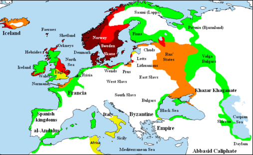
Viking_expansion.png(507 × 310 పిక్సెళ్ళు, ఫైలు పరిమాణం: 109 KB, MIME రకం: image/png)

(see en:File talk:Viking Expansion.svg)

సారాంశం

వివరణ
English: Map showing area of Scandinavian settlement (Vikings and Normans descendants from Normandy) in
 
eighth century
 
ninth century
 
tenth century
 
eleventh century
 
denotes areas subjected to frequent Scandinavian contacts, but with little or no Scandinavian settlement
తేదీ 14 నవంబరు 2006 (original upload date)
మూలం Briangotts (original uploader)
కర్త Briangotts (original uploader)
అనుమతి
(ఈ దస్త్రాన్ని పునర్వినియోగించుకోవడం)
నేను, ఈ కృతి యొక్క కాపీహక్కుదారుని, దీన్ని ఇందుమూలముగా ఈ లైసెన్సుల క్రింద ప్రచురిస్తున్నాను:
GNU head ఈ కృతి యొక్క కర్తనైన నేను, ఇక నుండీ ఈ కృతిని కాపీ చేసుకోవడానికి, పంచి పెట్టడానికి మరియు/లేదా మార్పులు-చేర్పులు చేసుకోవడానికి GFDL, లైసెన్సు వెర్షను 1.2 లేదా దాని తరువాత స్వేచ్చా సాఫ్టువేరు ఫౌండేషను విడుదలచేసే ఏ GFDL లైసెన్సు ద్వారా నయినా అనుమతి ఇస్తున్నాను; ఈ కృతిలో మార్చకూడని బాగాలు లేవు, Front-Cover పాఠం లేదు, Back-Cover పాఠం లేదు. ఈ లైసెన్సు యొక్క పత్రం నకలును "జిఎన్‌యూ ఉచిత డాక్యుమెంటేషను లైసెన్సు" అని పిలుస్తున్న విభాగంలో ఉంది.
w:en:Creative Commons
ఆపాదింపు share alike
ఈ దస్త్రం క్రియేటివ్ కామన్స్ Attribution-Share Alike 3.0 Unported లైసెన్సు క్రింద లభ్యం.
ఇలా చేసేందుకు మీకు స్వేచ్ఛ ఉంది:
  • పంచుకోడానికి – ఈ కృతిని కాపీ చేసుకోవచ్చు, పంపిణీ చేయవచ్చు, ప్రసారమూ చేయవచ్చు
  • రీమిక్స్ చేయడానికి – కృతిని అనుకరించడానికి
క్రింది షరతులకు లోబడి:
  • ఆపాదింపు – సముచితమైన శ్రేయస్సును ఇవ్వాలి, లైసెన్సుకు లింకు ఇవ్వాలి, మార్పులేమైనా చేస్తే వాటిని సూచించాలి. అందుకు సముచితమైన పద్ధతి దేన్నైనా అవలంబించవచ్చు. కానీ మీకూ మీ వాడుకకూ హక్కుదారు అనుమతించారు అనే అర్థం వచ్చేటట్లుగా మాత్రం కాదు.
  • share alike – మీరు ఈ కృతిని అనుకరిస్తే, మారిస్తే, లేదా మెరుగుపరిస్తే తత్ఫలిత కృతిని ఇదే లైసెన్సు లేదా దీనికి అనుగుణ్యమైన లైసెన్సు క్రింద మాత్రమే పంపిణీ చేయాలి.
GFDL లైసెన్సు తాజాకరణలో భాగంగా ఈ దస్త్రానికి ఈ లైసెన్సింగు ట్యాగుని చేర్చారు.
పైవాటిలో మీకు నచ్చిన లైసెన్సునును ఎంచుకోవచ్చు.
ఇతర కూర్పులు

[మార్చు]

File:Viking Expansion.svg is a vector version of this file. It should be used in place of this PNG file when not inferior.

File:Viking expansion.png → File:Viking Expansion.svg

For more information, see Help:SVG.

In other languages
Alemannisch  Bahasa Indonesia  Bahasa Melayu  British English  català  čeština  dansk  Deutsch  eesti  English  español  Esperanto  euskara  français  Frysk  galego  hrvatski  Ido  italiano  lietuvių  magyar  Nederlands  norsk bokmål  norsk nynorsk  occitan  Plattdüütsch  polski  português  português do Brasil  română  Scots  sicilianu  slovenčina  slovenščina  suomi  svenska  Tiếng Việt  Türkçe  vèneto  Ελληνικά  беларуская (тарашкевіца)  български  македонски  нохчийн  русский  српски / srpski  татарча/tatarça  українська  ქართული  հայերեն  বাংলা  தமிழ்  മലയാളം  ไทย  한국어  日本語  简体中文  繁體中文  עברית  العربية  فارسی  +/−
New SVG image

Captions

Add a one-line explanation of what this file represents

Items portrayed in this file

చిత్రణ

copyright status ఇంగ్లీష్

copyrighted ఇంగ్లీష్

media type ఇంగ్లీష్

image/png

ఫైలు చరితం

తేదీ/సమయం ను నొక్కి ఆ సమయాన ఫైలు ఎలా ఉండేదో చూడవచ్చు.

(చిట్టచివరి | తొట్టతొలి) (10 కొత్తవి) () (10 | 20 | 50 | 100 | 250 | 500) చూపించు.
తేదీ/సమయంనఖచిత్రంకొలతలువాడుకరివ్యాఖ్య
ప్రస్తుత22:58, 25 ఫిబ్రవరి 201822:58, 25 ఫిబ్రవరి 2018 నాటి కూర్పు నఖచిత్రం507 × 310 (109 KB)AsmodimAdded the territory of the Norman "Kingdom of Africa (see the wikipedia article), conquests of the Norman kingdom of Sicily under Roger II
18:10, 5 ఆగస్టు 201618:10, 5 ఆగస్టు 2016 నాటి కూర్పు నఖచిత్రం507 × 310 (109 KB)TheutatisExpanded area in Italy according to Norman expansion.
10:52, 17 జూలై 200810:52, 17 జూలై 2008 నాటి కూర్పు నఖచిత్రం800 × 310 (140 KB)F7~commonswiki
21:14, 15 మే 200721:14, 15 మే 2007 నాటి కూర్పు నఖచిత్రం1,464 × 568 (51 KB)Briangotts== Summary == {{Information |Description= Map showing area of Scandinavian settlement in<br> {{legend|#800000|eighth centuries}} {{legend|#f00|ninth centuries}} {{legend|#ff8000|tenth centuries}} {{legend|#eded00|eleventh centuries}} {{legend|#0f0|denotes
13:58, 10 మే 200713:58, 10 మే 2007 నాటి కూర్పు నఖచిత్రం1,464 × 568 (51 KB)Briangotts== Summary == {{Information |Description= Map showing area of Scandinavian settlement in<br> {{legend|#800000|eighth century}} {{legend|#f00|ninth century}} {{legend|#ff8000|tenth century}} {{legend|#eded00|eleventh century}} {{legend|#0f0|denotes areas s
19:56, 16 ఏప్రిల్ 200719:56, 16 ఏప్రిల్ 2007 నాటి కూర్పు నఖచిత్రం1,464 × 568 (33 KB)Tene~commonswikiOptimised (0)
11:43, 23 ఫిబ్రవరి 200711:43, 23 ఫిబ్రవరి 2007 నాటి కూర్పు నఖచిత్రం1,464 × 568 (79 KB)Dbachmann"yellow"
11:33, 23 ఫిబ్రవరి 200711:33, 23 ఫిబ్రవరి 2007 నాటి కూర్పు నఖచిత్రం1,464 × 568 (80 KB)Dbachmanncropped, fiddled with Iceland.
18:58, 2 ఫిబ్రవరి 200718:58, 2 ఫిబ్రవరి 2007 నాటి కూర్పు నఖచిత్రం1,838 × 710 (62 KB)Tene~commonswikiOptimised (0)
12:50, 20 జనవరి 200712:50, 20 జనవరి 2007 నాటి కూర్పు నఖచిత్రం1,838 × 710 (110 KB)Liftarn{{Information |Description=Map showing area of Scandinavian settlement in the eighth (dark red), ninth (red), tenth (orange) and eleventh (yellow) centuries. Green denotes areas subjected to frequent en:Viking raids. [[:e
(చిట్టచివరి | తొట్టతొలి) (10 కొత్తవి) () (10 | 20 | 50 | 100 | 250 | 500) చూపించు.

ఈ ఫైలును వాడుతున్న పేజీలు లేవు.

సార్వత్రిక ఫైలు వాడుక

ఈ దస్త్రాన్ని ఈ క్రింది ఇతర వికీలు ఉపయోగిస్తున్నాయి:

మెటాడేటా

"https://te.wikipedia.org/wiki/దస్త్రం:Viking_expansion.png" నుండి వెలికితీశారు