దస్త్రం:Wfm mono lake landsat.jpg
Jump to navigation
Jump to search

ఈ మునుజూపు పరిమాణం: 800 × 593 పిక్సెళ్ళు. ఇతర రిజల్యూషన్లు: 320 × 237 పిక్సెళ్ళు | 640 × 474 పిక్సెళ్ళు | 1,024 × 758 పిక్సెళ్ళు | 1,280 × 948 పిక్సెళ్ళు.
అసలు దస్త్రం (1,280 × 948 పిక్సెళ్ళు, ఫైలు పరిమాణం: 217 KB, MIME రకం: image/jpeg)
This is a file from the Wikimedia Commons. Information from its description page there is shown below. Commons is a freely licensed media file repository. You can help. |
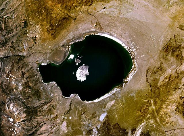
| వివరణ | Mono Lake in California, USA. a NASA Landsat 7 image, final image made using NASA World Wind. | |||
| తేదీ | 21 అక్టోబరు 2006 (original upload date) | |||
| మూలం | NASA WorldWind | |||
| కర్త | Finlay McWalter (చర్చ · రచనలు) | |||
| అనుమతి (ఈ దస్త్రాన్ని పునర్వినియోగించుకోవడం) |
|

ఫైలు చరితం
తేదీ/సమయం ను నొక్కి ఆ సమయాన ఫైలు ఎలా ఉండేదో చూడవచ్చు.
| తేదీ/సమయం | నఖచిత్రం | కొలతలు | వాడుకరి | వ్యాఖ్య | |
|---|---|---|---|---|---|
| ప్రస్తుత | 18:20, 21 అక్టోబరు 2006 | | 1,280 × 948 (217 KB) | Finlay McWalter | Mono Lake in California, USA NASA Landsat 7 image. Final image made using NASA World Wind. {{PD-WorldWind}} category:Lakes in California |
లింకులు
కింది పేజీలలో ఈ ఫైలుకు లింకులు ఉన్నాయి:
సార్వత్రిక ఫైలు వాడుక
ఈ దస్త్రాన్ని ఈ క్రింది ఇతర వికీలు ఉపయోగిస్తున్నాయి:
- ar.wikipedia.org లో వాడుక
- bg.wikipedia.org లో వాడుక
- ceb.wikipedia.org లో వాడుక
- cs.wikipedia.org లో వాడుక
- da.wikipedia.org లో వాడుక
- en.wikipedia.org లో వాడుక
- es.wikipedia.org లో వాడుక
- et.wikipedia.org లో వాడుక
- fr.wikipedia.org లో వాడుక
- fr.wikivoyage.org లో వాడుక
- hu.wikipedia.org లో వాడుక
- it.wikipedia.org లో వాడుక
- ko.wikipedia.org లో వాడుక
- li.wikipedia.org లో వాడుక
- mg.wikipedia.org లో వాడుక
- nl.wikipedia.org లో వాడుక
- nn.wikipedia.org లో వాడుక
- no.wikipedia.org లో వాడుక
- pt.wikipedia.org లో వాడుక
- ru.wikipedia.org లో వాడుక
- sh.wikipedia.org లో వాడుక
- sr.wikipedia.org లో వాడుక
- vi.wikipedia.org లో వాడుక
- zh-yue.wikipedia.org లో వాడుక
- zh.wikipedia.org లో వాడుక