దస్త్రం:Balkan topo en.jpg
Jump to navigation
Jump to search

ఈ మునుజూపు పరిమాణం: 657 × 600 పిక్సెళ్ళు. ఇతర రిజల్యూషన్లు: 263 × 240 పిక్సెళ్ళు | 526 × 480 పిక్సెళ్ళు | 840 × 767 పిక్సెళ్ళు.
అసలు దస్త్రం (840 × 767 పిక్సెళ్ళు, ఫైలు పరిమాణం: 638 KB, MIME రకం: image/jpeg)
This is a file from the Wikimedia Commons. Information from its description page there is shown below. Commons is a freely licensed media file repository. You can help. |
సారాంశం
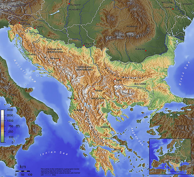
| వివరణ |
English: The topography of the Balkan Peninsula, as defined by the Danube-Sava-Kupa line. |
||||||||||
| తేదీ | 2006, before Serbia and Montenegro was split into two separate states. | ||||||||||
| మూలం | స్వంత కృతి | ||||||||||
| కర్త | Captain Blood~commonswiki | ||||||||||
| అనుమతి (ఈ దస్త్రాన్ని పునర్వినియోగించుకోవడం) |
|
||||||||||
| ఇతర కూర్పులు |
|

ఫైలు చరితం
తేదీ/సమయం ను నొక్కి ఆ సమయాన ఫైలు ఎలా ఉండేదో చూడవచ్చు.
| తేదీ/సమయం | నఖచిత్రం | కొలతలు | వాడుకరి | వ్యాఖ్య | |
|---|---|---|---|---|---|
| ప్రస్తుత | 09:15, 14 నవంబరు 2015 | | 840 × 767 (638 KB) | SilentResident | Corrected mistake in which the Aegean and Ionian islands were marked as part of the Balkan topography. |
| 21:53, 1 ఫిబ్రవరి 2012 |  | 1,384 × 1,264 (726 KB) | Ras67 | losslessly cropped with Jpegcrop | |
| 21:52, 1 ఫిబ్రవరి 2012 |  | 1,384 × 1,264 (726 KB) | Ras67 | losslessly cropped with Jpegcrop | |
| 17:34, 14 ఏప్రిల్ 2006 |  | 1,400 × 1,278 (748 KB) | Captain Blood~commonswiki | labels | |
| 17:22, 2 ఏప్రిల్ 2006 |  | 1,400 × 1,278 (748 KB) | Captain Blood~commonswiki | Una border | |
| 19:38, 1 ఏప్రిల్ 2006 |  | 1,400 × 1,278 (741 KB) | Captain Blood~commonswiki | {{Bild-GFDL-GMT}} |
లింకులు
కింది పేజీలలో ఈ ఫైలుకు లింకులు ఉన్నాయి:
సార్వత్రిక ఫైలు వాడుక
ఈ దస్త్రాన్ని ఈ క్రింది ఇతర వికీలు ఉపయోగిస్తున్నాయి:
- af.wikipedia.org లో వాడుక
- ang.wikipedia.org లో వాడుక
- an.wikipedia.org లో వాడుక
- ar.wikipedia.org లో వాడుక
- arz.wikipedia.org లో వాడుక
- ast.wikipedia.org లో వాడుక
- be-tarask.wikipedia.org లో వాడుక
- bg.wikipedia.org లో వాడుక
- bn.wikipedia.org లో వాడుక
- bs.wikipedia.org లో వాడుక
- ca.wikipedia.org లో వాడుక
- ckb.wikipedia.org లో వాడుక
ఈ దస్త్రపు మరింత సార్వత్రిక వాడుకను చూడండి.