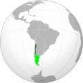
దస్త్రం:Captaincy General of Chile (orthographic projection).svg

వికీపీడియా నుండి
Jump to navigation Jump to search

అసలు దస్త్రం (SVG ఫైలు, నామమాత్రంగా 550 × 550 పిక్సెళ్ళు, ఫైలు పరిమాణం: 844 KB)

సారాంశం

వివరణ
English: Approximate extension of the Captaincy General of Chile in orthographic projection.
 
Territory under effective control of the Captaincy by 1786.
 
Territory of the Captaincy, ceded or transferred before 1786.
striped 2
Claimed, disputed, not under effective control or only nominal control territory associated to the Captaincy by 1786.
striped 2
Claimed, disputed, not under effective control or only nominal control territory associated with ceded territories of the Captaincy.
Español: Ubicación geográfica aproximada de la Capitanía General de Chile en proyección ortográfica.
 
Territorio efectivo de la Capitanía hacia 1786.
 
Territorio de la Capitanía, cedido o transferido a otras entidades previo a 1786.
striped 2
Territorio reclamado, disputado, sin control efectivo o sólo control nominal asociado a la Capitanía hacia 1786.
striped 2
Territorio reclamado, disputado, sin control efectivo o sólo control nominal asociado a territorios cedidos por la Capitanía.
తేదీ
మూలం

Own work based on: the Brazil (orthographic projection).svg, created by the Wikimedia Commons user Ssolbergj, under a Creative Commons Licence.

Boundaries based in the following sources:

కర్త B1mbo
అనుమతి
(ఈ దస్త్రాన్ని పునర్వినియోగించుకోవడం)
నేను, ఈ కృతి యొక్క కాపీహక్కుదారుని, దీన్ని ఈ లైసెన్సు క్రింద ఇందుమూలముగా ప్రచురిస్తున్నాను:
w:en:Creative Commons
ఆపాదింపు
ఈ ఫైలు అనుమతి సాధారణ సృజనాత్మకము అపాదింపు ౩.౦ ఆన్-పోర్టెడ్ యందు అనుమతించబడినది.
ఇలా చేసేందుకు మీకు స్వేచ్ఛ ఉంది:
  • పంచుకోడానికి – ఈ కృతిని కాపీ చేసుకోవచ్చు, పంపిణీ చేయవచ్చు, ప్రసారమూ చేయవచ్చు
  • రీమిక్స్ చేయడానికి – కృతిని అనుకరించడానికి
క్రింది షరతులకు లోబడి:
  • ఆపాదింపు – సముచితమైన శ్రేయస్సును ఇవ్వాలి, లైసెన్సుకు లింకు ఇవ్వాలి, మార్పులేమైనా చేస్తే వాటిని సూచించాలి. అందుకు సముచితమైన పద్ధతి దేన్నైనా అవలంబించవచ్చు. కానీ మీకూ మీ వాడుకకూ హక్కుదారు అనుమతించారు అనే అర్థం వచ్చేటట్లుగా మాత్రం కాదు.
ఇతర కూర్పులు
This is a Grey & green orthographic projection map.
العربية: الرجاء، قراءة الميثاق.
বাংলা: দয়া করে, রীতিনীতিটি পড়ুন
Deutsch: Bitte lies die Konventionen.
English: Please, read the conventions.
Español: Por favor, lea las convenciones.
Filipino: Paki-basa ang mga kumbensyon.
Français : S'il vous plaît, lisez les conventions.
हिन्दी: कृपया सभागमों को पढ़ लें.
Bahasa Indonesia: Silakan, baca konvensi.
Italiano: Si prega di leggere le convenzioni.
日本語: 規約をご確認ください。
ქართული: გთხოვთ, გაეცნოთ კონვენციებს.
Português: Por favor, leia as convenções.
Русский: Пожалуйста, прочитайте соглашения.
Українська: Будь ласка, прочитайте конвенції.
Tiếng Việt: Hãy đọc công văn trước khi đăng.
中文(繁體):請檢視常規
中文(简体):请查看常规
World maps

Africa

हिन्दी: अफ्रीका
ქართული: აფრიკა.

Eastern Africa

Southern Africa

Central Africa

Northern Africa

Western Africa

Americas

ქართული: ამერიკა.
हिन्दी: अमेरिका

North America

Central America

Caribbean

South America

Asia

ქართული: აზია.
Português: Ásia.
Українська: Азія.

East

Português: Ásia Oriental.
Українська: Східна Азія.

Central

हिन्दी: मध्य एशिया
Português: Ásia Central.
Українська: Центральна Азія.

Southeast

Bahasa Indonesia: Asia tenggara
Português: Sudeste Asiático.

South

(भारतीय उपमहाद्वीप)
Português: Sul da Ásia.
Українська: Південна Азія.

Western

Português: Sudoeste da Ásia.
Українська: Передня Азія.

Europe

हिन्दी: यूरोप
ქართული: ევროპა.
Português: Europa.
Română: Europa.
Русский: Европа.
Українська: Європа.

Countries

Oceania

हिन्दी: ओशिआनिया
ქართული: ოკეანეთი.
Português: Oceania.
Українська: Океанія.

Intercontinental

Português: Intercontinental.
Українська: Міжконтинентальні.

Historical

English: Unions, Organizations, Kingdoms, Empires
Español: Uniones, Organizaciones, Reinos, Imperios
Filipino: Mga Unyon, Organisasyon, Kaharian, Imperyo
Français : Unions, Organisations, Royaumes, Empires
हिन्दी: संघ, संगठन, राज्य, साम्राज्य व ऐतिहासिक देश
ქართული: გაერთიანებები, ორგანიზაციები, სამეფოები, იმპერიები
Português: Estados extintos.
Tagalog: Mga Unyon, Organisasyon, Kaharian, Imperyo
Українська: Союзи, Організації, Королівства, Імперії
中文(繁體):聯盟、組織、王國和帝國
中文(简体):联盟、组织、王国和帝国

Subnationals

हिन्दी: उपराष्ट्रीय इकाईयाँ
Orthographic projections maps created by Ssolbergj
Orthographic projections maps created by Ssolbergj:
SVG పెరుగుదల
InfoField
 
The SVG code is valid.
 
This world map was created with Inkscape.

Captions

Add a one-line explanation of what this file represents

Items portrayed in this file

చిత్రణ

media type ఇంగ్లీష్

image/svg+xml

checksum ఇంగ్లీష్

7ab9b71e45029676fd9b1c604be81c33a2ea5ce9

data size ఇంగ్లీష్

8,63,977 బైట్

550 చిణువు

550 చిణువు

ఫైలు చరితం

తేదీ/సమయం ను నొక్కి ఆ సమయాన ఫైలు ఎలా ఉండేదో చూడవచ్చు.

తేదీ/సమయంనఖచిత్రంకొలతలువాడుకరివ్యాఖ్య
ప్రస్తుత19:36, 7 నవంబరు 202219:36, 7 నవంబరు 2022 నాటి కూర్పు నఖచిత్రం550 × 550 (844 KB)JanitoalevicBorders bases on the Map of Cano y Olmedilla of 1775
16:54, 18 అక్టోబరు 202216:54, 18 అక్టోబరు 2022 నాటి కూర్పు నఖచిత్రం550 × 550 (373 KB)JanitoalevicAdded Terra Australis (1555) and Easter Island (1770)
22:37, 7 జూలై 202222:37, 7 జూలై 2022 నాటి కూర్పు నఖచిత్రం550 × 550 (364 KB)Janitoaleviclímite en el río Loa entre la prov. de Santiago y Arequipa (Eyzaguirre, Jaime, 1967)
22:11, 19 సెప్టెంబరు 201922:11, 19 సెప్టెంబరు 2019 నాటి కూర్పు నఖచిత్రం550 × 550 (253 KB)B1mboCorrecciones
17:00, 10 జూలై 201217:00, 10 జూలై 2012 నాటి కూర్పు నఖచిత్రం550 × 550 (139 KB)JespinosReverted to version as of 16:58, 10 July 2012
16:58, 10 జూలై 201216:58, 10 జూలై 2012 నాటి కూర్పు నఖచిత్రం550 × 550 (150 KB)JespinosReverted to version as of 09:07, 26 May 2012
16:58, 10 జూలై 201216:58, 10 జూలై 2012 నాటి కూర్పు నఖచిత్రం550 × 550 (139 KB)JespinosReverted to version as of 23:27, 20 June 2010
09:07, 26 మే 201209:07, 26 మే 2012 నాటి కూర్పు నఖచిత్రం550 × 550 (150 KB)Franco-eisenhowerLímite verdadero Patagonia: http://www.scielo.cl/scielo.php?pid=S0717-71942002003500009&script=sci_arttext&tlng=es
23:27, 20 జూన్ 201023:27, 20 జూన్ 2010 నాటి కూర్పు నఖచిత్రం550 × 550 (139 KB)B1mbo== Summary == {{created with Inkscape}} {{Information |Description= {{en|Location of the Captaincy General of Chile in orthographic projection, approx. 1796. {{legend|DarkGreen|Sovereign territory.}} {{legend|Lime|Terr

ఈ ఫైలును వాడుతున్న పేజీలు లేవు.

సార్వత్రిక ఫైలు వాడుక

ఈ దస్త్రాన్ని ఈ క్రింది ఇతర వికీలు ఉపయోగిస్తున్నాయి:

మెటాడేటా