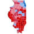
దస్త్రం:Illinois Presidential Election Results 2020.svg

వికీపీడియా నుండి
Jump to navigation Jump to search

అసలు దస్త్రం(SVG ఫైలు, నామమాత్రంగా 810 × 810 పిక్సెళ్ళు, ఫైలు పరిమాణం: 22 KB)

సారాంశం

వివరణ
English: State election results in Illinois, by county – presidential election 2020.
 
Biden—>90%
 
Biden—80-90%
 
Biden—70-80%
 
Biden—60-70%
 
Biden—50-60%
 
Biden—40-50%
 
Biden—30-40%
 
Trump—30-40%
 
Trump—40-50%
 
Trump—50-60%
 
Trump—60-70%
 
Trump—70-80%
 
Trump—80-90%
 
Trump—>90%
తేదీ
మూలం స్వంత కృతి
కర్త TylerKutschbach

లైసెన్సింగ్

Public domain This map is ineligible for copyright and therefore in the public domain, because it consists entirely of information that is common property and contains no original authorship. For more information, see Commons:Threshold of originality § Maps.

English | Español | Galego | Română | slovenščina | العربية | 简体中文 | 繁體中文 | +/−

Though this map is believed to be in the public domain, it was released under the following license:

నేను, ఈ కృతి యొక్క కాపీహక్కుదారుని, దీన్ని ఈ లైసెన్సు క్రింద ఇందుమూలముగా ప్రచురిస్తున్నాను:
w:en:Creative Commons
ఆపాదింపు share alike
This file is licensed under the Creative Commons Attribution-Share Alike 4.0 International license.
ఇలా చేసేందుకు మీకు స్వేచ్ఛ ఉంది:
  • పంచుకోడానికి – ఈ కృతిని కాపీ చేసుకోవచ్చు, పంపిణీ చేయవచ్చు, ప్రసారమూ చేయవచ్చు
  • రీమిక్స్ చేయడానికి – కృతిని అనుకరించడానికి
క్రింది షరతులకు లోబడి:
  • ఆపాదింపు – సముచితమైన శ్రేయస్సును ఇవ్వాలి, లైసెన్సుకు లింకు ఇవ్వాలి, మార్పులేమైనా చేస్తే వాటిని సూచించాలి. అందుకు సముచితమైన పద్ధతి దేన్నైనా అవలంబించవచ్చు. కానీ మీకూ మీ వాడుకకూ హక్కుదారు అనుమతించారు అనే అర్థం వచ్చేటట్లుగా మాత్రం కాదు.
  • share alike – మీరు ఈ కృతిని అనుకరిస్తే, మారిస్తే, లేదా మెరుగుపరిస్తే తత్ఫలిత కృతిని ఇదే లైసెన్సు లేదా దీనికి అనుగుణ్యమైన లైసెన్సు క్రింద మాత్రమే పంపిణీ చేయాలి.

Captions

Add a one-line explanation of what this file represents

copyright status ఇంగ్లీష్

copyrighted ఇంగ్లీష్

source of file ఇంగ్లీష్

original creation by uploader ఇంగ్లీష్

media type ఇంగ్లీష్

image/svg+xml

ఫైలు చరితం

తేదీ/సమయం ను నొక్కి ఆ సమయాన ఫైలు ఎలా ఉండేదో చూడవచ్చు.

(చిట్టచివరి | తొట్టతొలి) (10 కొత్తవి) () (10 | 20 | 50 | 100 | 250 | 500) చూపించు.
తేదీ/సమయంనఖచిత్రంకొలతలువాడుకరివ్యాఖ్య
ప్రస్తుత21:16, 2 ఏప్రిల్ 202421:16, 2 ఏప్రిల్ 2024 నాటి కూర్పు నఖచిత్రం810 × 810 (22 KB)CottonDugganReverted to version as of 19:43, 1 November 2023 (UTC) these are the correct results according to Dave Leip’s
03:23, 1 ఏప్రిల్ 202403:23, 1 ఏప్రిల్ 2024 నాటి కూర్పు నఖచిత్రం810 × 810 (25 KB)Gordfather69Fix
19:43, 1 నవంబరు 202319:43, 1 నవంబరు 2023 నాటి కూర్పు నఖచిత్రం810 × 810 (22 KB)GraydenCatReverted to version as of 22:19, 2 October 2023 (UTC) these are the correct results
01:55, 31 అక్టోబరు 202301:55, 31 అక్టోబరు 2023 నాటి కూర్పు నఖచిత్రం810 × 810 (43 KB)CrookCoMaps61Reverted to version as of 02:48, 3 August 2023 (UTC)
22:19, 2 అక్టోబరు 202322:19, 2 అక్టోబరు 2023 నాటి కూర్పు నఖచిత్రం810 × 810 (22 KB)GraydenCatCorrected Winnebago, Fayette and McHenry Counties
02:48, 3 ఆగస్టు 202302:48, 3 ఆగస్టు 2023 నాటి కూర్పు నఖచిత్రం810 × 810 (43 KB)Putitonamap98shapes
04:28, 11 ఏప్రిల్ 202304:28, 11 ఏప్రిల్ 2023 నాటి కూర్పు నఖచిత్రం744 × 744 (284 KB)CrookCoMaps61Fixed Fayette, McHenry, and Winnebago Counties.
04:45, 4 మార్చి 202304:45, 4 మార్చి 2023 నాటి కూర్పు నఖచిత్రం744 × 744 (284 KB)CrookCoMaps61Fixed Macon County
06:02, 13 జనవరి 202306:02, 13 జనవరి 2023 నాటి కూర్పు నఖచిత్రం744 × 744 (284 KB)Putitonamap98shapes
21:43, 26 ఆగస్టు 202221:43, 26 ఆగస్టు 2022 నాటి కూర్పు నఖచిత్రం187 × 338 (14 KB)TylerKutschbachUpdated results
(చిట్టచివరి | తొట్టతొలి) (10 కొత్తవి) () (10 | 20 | 50 | 100 | 250 | 500) చూపించు.

ఈ ఫైలును వాడుతున్న పేజీలు లేవు.

సార్వత్రిక ఫైలు వాడుక

ఈ దస్త్రాన్ని ఈ క్రింది ఇతర వికీలు ఉపయోగిస్తున్నాయి:

మెటాడేటా