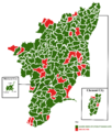
దస్త్రం:2011 tamil nadu legislative election map.png
Jump to navigation
Jump to search

ఈ మునుజూపు పరిమాణం: 509 × 600 పిక్సెళ్ళు. ఇతర రిజల్యూషన్లు: 204 × 240 పిక్సెళ్ళు | 407 × 480 పిక్సెళ్ళు | 652 × 768 పిక్సెళ్ళు | 869 × 1,024 పిక్సెళ్ళు | 1,739 × 2,048 పిక్సెళ్ళు | 2,596 × 3,058 పిక్సెళ్ళు.
అసలు దస్త్రం (2,596 × 3,058 పిక్సెళ్ళు, ఫైలు పరిమాణం: 1.1 MB, MIME రకం: image/png)
ఫైలు చరితం
తేదీ/సమయం ను నొక్కి ఆ సమయాన ఫైలు ఎలా ఉండేదో చూడవచ్చు.
| తేదీ/సమయం | నఖచిత్రం | కొలతలు | వాడుకరి | వ్యాఖ్య | |
|---|---|---|---|---|---|
| ప్రస్తుత | 23:55, 28 మే 2011 |  | 2,596 × 3,058 (1.1 MB) | Nader85021 | Made corrections and fixed mistakes. Named the specific madurai constituencies |
| 04:49, 23 మే 2011 |  | 2,596 × 3,058 (4.02 MB) | Nader85021 | added boxes and labeled chennai and madurai. | |
| 20:49, 22 మే 2011 |  | 2,596 × 3,058 (3.44 MB) | Nader85021 | fixed a few mistakes on the map. Certain constituencies were changed to INC and DMK, so their alliance total is 31. | |
| 21:39, 13 మే 2011 |  | 487 × 574 (149 KB) | Nader85021 | ||
| 19:29, 13 మే 2011 |  | 487 × 574 (141 KB) | Nader85021 | {{Information |Description ={{en|1=made election map using borders from ECI website. Results based on ECI website: http://eciresults.ap.nic.in/. Harbour constituency not filled in due to votes being still counted.}} |Source ={{own}} |Author |
లింకులు
కింది పేజీలలో ఈ ఫైలుకు లింకులు ఉన్నాయి:
సార్వత్రిక ఫైలు వాడుక
ఈ దస్త్రాన్ని ఈ క్రింది ఇతర వికీలు ఉపయోగిస్తున్నాయి:
- en.wikipedia.org లో వాడుక
- id.wikipedia.org లో వాడుక