దస్త్రం:Pallava territories.png
Jump to navigation
Jump to search
మరింత స్పష్టమైన బొమ్మ లేదు.
Pallava_territories.png (270 × 143 పిక్సెళ్ళు, ఫైలు పరిమాణం: 9 KB, MIME రకం: image/png)
This is a file from the Wikimedia Commons. Information from its description page there is shown below. Commons is a freely licensed media file repository. You can help. |
సారాంశం

|
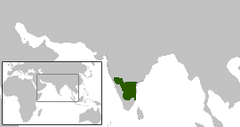
This map has been uploaded by Electionworld from en.wikipedia.org to enable the |
Pallava territories during Narasimhavarman I c. 645 CE. This includes the Chalukya territories occupied by the Pallavas.
Map created using the Wikipedia blank maps and modified using Adobe Photoshop
map shown here cotradicts the map shown in calukya period webpage. please retain yhe one which is historically accurate
లైసెన్సింగ్
Venu62, ఈ కృతి యొక్క కాపీహక్కుదారు, దీన్ని ఇందుమూలముగా ఈ లైసెన్సు క్రింద ప్రచురిస్తున్నారు:

|
ఈ కృతి యొక్క కర్తనైన నేను, ఇక నుండీ ఈ కృతిని కాపీ చేసుకోవడానికి, పంచి పెట్టడానికి మరియు/లేదా మార్పులు-చేర్పులు చేసుకోవడానికి GFDL, లైసెన్సు వెర్షను 1.2 లేదా దాని తరువాత స్వేచ్చా సాఫ్టువేరు ఫౌండేషను విడుదలచేసే ఏ GFDL లైసెన్సు ద్వారా నయినా అనుమతి ఇస్తున్నాను; ఈ కృతిలో మార్చకూడని బాగాలు లేవు, Front-Cover పాఠం లేదు, Back-Cover పాఠం లేదు. ఈ లైసెన్సు యొక్క పత్రం నకలును "జిఎన్యూ ఉచిత డాక్యుమెంటేషను లైసెన్సు" అని పిలుస్తున్న విభాగంలో ఉంది. |
| ఈ దస్త్రం క్రియేటివ్ కామన్స్ Attribution-Share Alike 3.0 Unported లైసెన్సు క్రింద లభ్యం. | ||
| ఆపాదింపు: Venu62 | ||
| ||
| GFDL లైసెన్సు తాజాకరణలో భాగంగా ఈ దస్త్రానికి ఈ లైసెన్సింగు ట్యాగుని చేర్చారు. |
ఫైలు చరితం
తేదీ/సమయం ను నొక్కి ఆ సమయాన ఫైలు ఎలా ఉండేదో చూడవచ్చు.
| తేదీ/సమయం | నఖచిత్రం | కొలతలు | వాడుకరి | వ్యాఖ్య | |
|---|---|---|---|---|---|
| ప్రస్తుత | 23:29, 13 డిసెంబరు 2006 | | 270 × 143 (9 KB) | Electionworld | {{ew|en|Venu62}} Pallava territories during Narasimhavarman I c. 645 CE. This includes the Chalukya territories occupied by the Pallavas. Map created using the Wikipedia blank maps and modified using Adobe Photoshop map shown here cotradicts the |
లింకులు
కింది పేజీలలో ఈ ఫైలుకు లింకులు ఉన్నాయి:
సార్వత్రిక ఫైలు వాడుక
ఈ దస్త్రాన్ని ఈ క్రింది ఇతర వికీలు ఉపయోగిస్తున్నాయి:
- ar.wikipedia.org లో వాడుక
- as.wikipedia.org లో వాడుక
- bn.wikipedia.org లో వాడుక
- br.wikipedia.org లో వాడుక
- ca.wikipedia.org లో వాడుక
- de.wikipedia.org లో వాడుక
- en.wikipedia.org లో వాడుక
- es.wikipedia.org లో వాడుక
- eu.wikipedia.org లో వాడుక
- fa.wikipedia.org లో వాడుక
- fi.wikipedia.org లో వాడుక
- fr.wikipedia.org లో వాడుక
- hi.wikipedia.org లో వాడుక
- hr.wikipedia.org లో వాడుక
- hu.wikipedia.org లో వాడుక
- it.wikipedia.org లో వాడుక
- ja.wikipedia.org లో వాడుక
- ka.wikipedia.org లో వాడుక
- ko.wikipedia.org లో వాడుక
- lt.wikipedia.org లో వాడుక
- ml.wikipedia.org లో వాడుక
- ms.wikipedia.org లో వాడుక
- ne.wikipedia.org లో వాడుక
- nl.wikipedia.org లో వాడుక
- nn.wikipedia.org లో వాడుక
- no.wikipedia.org లో వాడుక
- oc.wikipedia.org లో వాడుక
- pl.wikipedia.org లో వాడుక
- pnb.wikipedia.org లో వాడుక
- pt.wikipedia.org లో వాడుక
- ru.wikipedia.org లో వాడుక
- sh.wikipedia.org లో వాడుక
- sq.wikipedia.org లో వాడుక
- ta.wikipedia.org లో వాడుక
- ta.wiktionary.org లో వాడుక
- uk.wikipedia.org లో వాడుక
ఈ దస్త్రపు మరింత సార్వత్రిక వాడుకను చూడండి.