దస్త్రం:Pre Historic Mid Krishna-Tungabhadra Valley sites.jpg
Jump to navigation
Jump to search
ఈ మునుజూపు పరిమాణం: 726 × 600 పిక్సెళ్ళు. ఇతర రిజల్యూషన్లు: 291 × 240 పిక్సెళ్ళు | 581 × 480 పిక్సెళ్ళు | 929 × 768 పిక్సెళ్ళు | 1,239 × 1,024 పిక్సెళ్ళు | 2,338 × 1,932 పిక్సెళ్ళు.
అసలు దస్త్రం (2,338 × 1,932 పిక్సెళ్ళు, ఫైలు పరిమాణం: 876 KB, MIME రకం: image/jpeg)
This is a file from the Wikimedia Commons. Information from its description page there is shown below. Commons is a freely licensed media file repository. You can help. |

|
This historical map image could be re-created using vector graphics as an SVG file. This has several advantages; see Commons:Media for cleanup for more information. If an SVG form of this image is available, please upload it and afterwards replace this template with
{{vector version available|new image name}}.
It is recommended to name the SVG file “Pre Historic Mid Krishna-Tungabhadra Valley sites.svg”—then the template Vector version available (or Vva) does not need the new image name parameter. |


సారాంశం
| వివరణ |
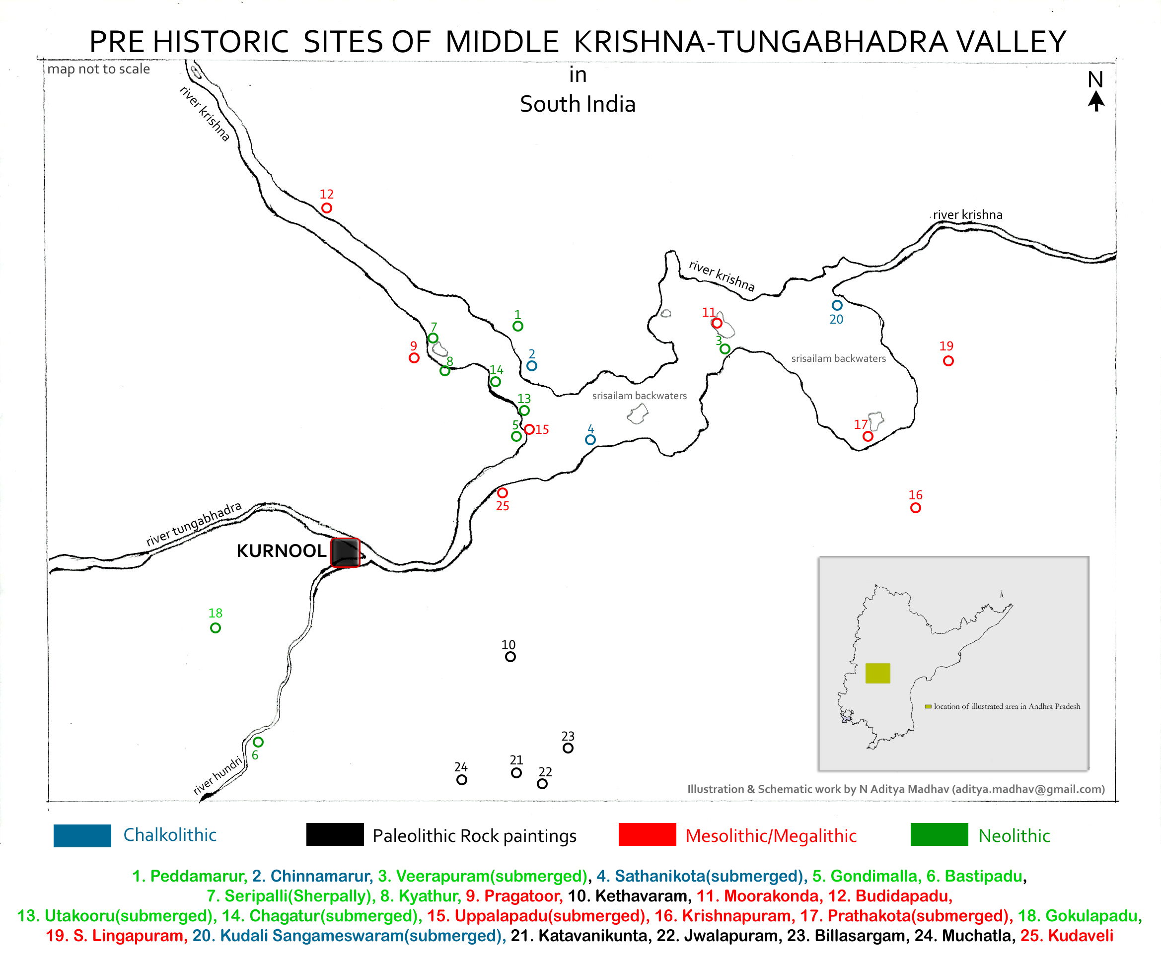
English: Pre Historic Mid Krishna-Tungabhadra Valley sites are:
1. Peddamarur, 2. Chinnamarur, 3. Veerapuram(submerged), 4. Sathanikota(submerged), 5. Gondimalla, 6. Bastipadu, 7. Seripalli(Sherpally), 8. Kyathur, 9. Pragatoor, 10. Kethavaram, 11. Moorakonda, 12. Budidapadu, 13. Utakooru(submerged), 14. Chagatur(submerged), 15. Uppalapadu(submerged), 16. Krishnapuram, 17. Prathakota(submerged), 18. Gokulapadu, 19. S. Lingapuram, 20. Kudali Sangameswaram(submerged), 21. Katavanikunta, 22. Jwalapuram, 23. Billasargam, 24. Muchatla, 25. Kudaveli Note: The map is created for information and educational purposes. People using the map outside Wikipedia projects are requested to attribute it properly. |
| తేదీ | |
| మూలం | స్వంత కృతి |
| కర్త | Adityamadhav83 |
Data collected from Department of Archaeology and Museums, Hyderabad, Andhra Pradesh and Journals on Proto Historic culture and settlements in Andhra Pradesh.
లైసెన్సింగ్
నేను, ఈ కృతి యొక్క కాపీహక్కుదారుని, దీన్ని ఈ లైసెన్సు క్రింద ఇందుమూలముగా ప్రచురిస్తున్నాను:
ఈ దస్త్రం క్రియేటివ్ కామన్స్ Attribution-Share Alike 3.0 Unported లైసెన్సు క్రింద లభ్యం.
- ఇలా చేసేందుకు మీకు స్వేచ్ఛ ఉంది:
- పంచుకోడానికి – ఈ కృతిని కాపీ చేసుకోవచ్చు, పంపిణీ చేయవచ్చు, ప్రసారమూ చేయవచ్చు
- రీమిక్స్ చేయడానికి – కృతిని అనుకరించడానికి
- క్రింది షరతులకు లోబడి:
- ఆపాదింపు – సముచితమైన శ్రేయస్సును ఇవ్వాలి, లైసెన్సుకు లింకు ఇవ్వాలి, మార్పులేమైనా చేస్తే వాటిని సూచించాలి. అందుకు సముచితమైన పద్ధతి దేన్నైనా అవలంబించవచ్చు. కానీ మీకూ మీ వాడుకకూ హక్కుదారు అనుమతించారు అనే అర్థం వచ్చేటట్లుగా మాత్రం కాదు.
- share alike – మీరు ఈ కృతిని అనుకరిస్తే, మారిస్తే, లేదా మెరుగుపరిస్తే తత్ఫలిత కృతిని ఇదే లైసెన్సు లేదా దీనికి అనుగుణ్యమైన లైసెన్సు క్రింద మాత్రమే పంపిణీ చేయాలి.
ఫైలు చరితం
తేదీ/సమయం ను నొక్కి ఆ సమయాన ఫైలు ఎలా ఉండేదో చూడవచ్చు.
| తేదీ/సమయం | నఖచిత్రం | కొలతలు | వాడుకరి | వ్యాఖ్య | |
|---|---|---|---|---|---|
| ప్రస్తుత | 06:55, 10 మే 2013 | | 2,338 × 1,932 (876 KB) | Adityamadhav83 | Location in Andhra Pradesh state included in the illustration |
| 19:31, 26 ఏప్రిల్ 2013 |  | 2,338 × 1,932 (848 KB) | Adityamadhav83 | User created page with UploadWizard |
లింకులు
కింది పేజీలలో ఈ ఫైలుకు లింకులు ఉన్నాయి:
సార్వత్రిక ఫైలు వాడుక
ఈ దస్త్రాన్ని ఈ క్రింది ఇతర వికీలు ఉపయోగిస్తున్నాయి:
- ar.wikipedia.org లో వాడుక
- bn.wikipedia.org లో వాడుక
- ca.wikipedia.org లో వాడుక
- de.wikipedia.org లో వాడుక
- en.wikipedia.org లో వాడుక
- es.wikipedia.org లో వాడుక
- fr.wikipedia.org లో వాడుక
- kn.wikipedia.org లో వాడుక
- mr.wikipedia.org లో వాడుక
- pa.wikipedia.org లో వాడుక
- pnb.wikipedia.org లో వాడుక
- si.wikipedia.org లో వాడుక
- sr.wikipedia.org లో వాడుక
- ta.wikipedia.org లో వాడుక
- tr.wikipedia.org లో వాడుక
- ur.wikipedia.org లో వాడుక
- zh.wikipedia.org లో వాడుక