దస్త్రం:Lakes of Africa.jpg
Jump to navigation
Jump to search
ఈ మునుజూపు పరిమాణం: 595 × 600 పిక్సెళ్ళు. ఇతర రిజల్యూషన్లు: 238 × 240 పిక్సెళ్ళు | 476 × 480 పిక్సెళ్ళు | 762 × 768 పిక్సెళ్ళు | 1,016 × 1,024 పిక్సెళ్ళు | 2,031 × 2,048 పిక్సెళ్ళు | 4,261 × 4,296 పిక్సెళ్ళు.
అసలు దస్త్రం (4,261 × 4,296 పిక్సెళ్ళు, ఫైలు పరిమాణం: 7.42 MB, MIME రకం: image/jpeg)
This is a file from the Wikimedia Commons. Information from its description page there is shown below. Commons is a freely licensed media file repository. You can help. |
సారాంశం
| వివరణ |
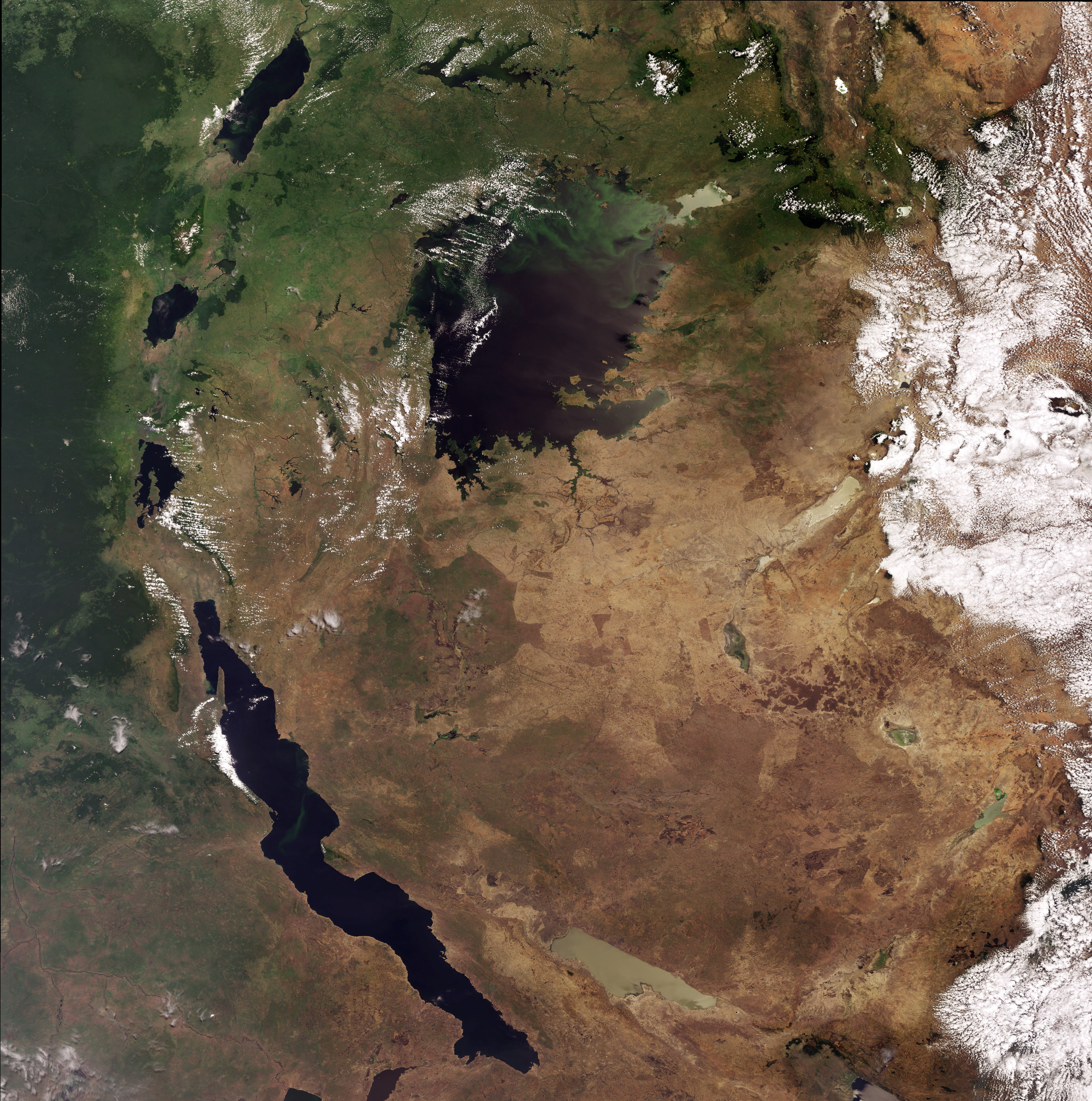
English: This Envisat image highlights lakes in the Western Rift of the Great Rift Valley, a geological fault system of Southwest Asia and East Africa: Lake Victoria, visible in the top centre, Kyoga, the lake above Victoria, Tanganyika, the oblong-shaped lake visible in the bottom left, Lake Albert, visible in the top left, Lake Edward, beneath Albert and Lake Kivu, beneath Edward. This image was acquired by Envisat's Medium Resolution Imaging Spectrometer (MERIS) on 6 October 2008, working in Full Resolution Mode providing a spatial resolution of 300 m. |
| తేదీ | |
| మూలం | http://www.esa.int/spaceinimages/Images/2008/10/Lakes_of_Africa |
| కర్త | European Space Agency |
| అనుమతి (ఈ దస్త్రాన్ని పునర్వినియోగించుకోవడం) |
ESA,CC BY-SA 3.0 IGO |
| ఇతర కూర్పులు |
|
| Title | Lakes of Africa |
| Keywords | Water (fresh); Lakes |
| Set | Earth observation image of the week |
| Mission | Envisat |
| Activity | Observing the Earth |

లైసెన్సింగ్
This file is licensed under the Creative Commons Attribution-ShareAlike 3.0 IGO license.
ఆపాదింపు: ESA
- ఇలా చేసేందుకు మీకు స్వేచ్ఛ ఉంది:
- పంచుకోడానికి – ఈ కృతిని కాపీ చేసుకోవచ్చు, పంపిణీ చేయవచ్చు, ప్రసారమూ చేయవచ్చు
- రీమిక్స్ చేయడానికి – కృతిని అనుకరించడానికి
- క్రింది షరతులకు లోబడి:
- ఆపాదింపు – సముచితమైన శ్రేయస్సును ఇవ్వాలి, లైసెన్సుకు లింకు ఇవ్వాలి, మార్పులేమైనా చేస్తే వాటిని సూచించాలి. అందుకు సముచితమైన పద్ధతి దేన్నైనా అవలంబించవచ్చు. కానీ మీకూ మీ వాడుకకూ హక్కుదారు అనుమతించారు అనే అర్థం వచ్చేటట్లుగా మాత్రం కాదు.
- share alike – మీరు ఈ కృతిని అనుకరిస్తే, మారిస్తే, లేదా మెరుగుపరిస్తే తత్ఫలిత కృతిని ఇదే లైసెన్సు లేదా దీనికి అనుగుణ్యమైన లైసెన్సు క్రింద మాత్రమే పంపిణీ చేయాలి.
ఫైలు చరితం
తేదీ/సమయం ను నొక్కి ఆ సమయాన ఫైలు ఎలా ఉండేదో చూడవచ్చు.
| తేదీ/సమయం | నఖచిత్రం | కొలతలు | వాడుకరి | వ్యాఖ్య | |
|---|---|---|---|---|---|
| ప్రస్తుత | 05:25, 2 మార్చి 2017 | | 4,261 × 4,296 (7.42 MB) | Revent | =={{int:filedesc}}== {{Photograph |photographer = Envisat satellite |title = Lakes of Africa |description = {{en|1=This Envisat image highlights lakes in the Western Rift of the Great Rift Valley, a geological fault system... |
లింకులు
కింది పేజీలలో ఈ ఫైలుకు లింకులు ఉన్నాయి:
సార్వత్రిక ఫైలు వాడుక
ఈ దస్త్రాన్ని ఈ క్రింది ఇతర వికీలు ఉపయోగిస్తున్నాయి:
- en.wikipedia.org లో వాడుక
- eu.wikipedia.org లో వాడుక