దస్త్రం:Lower Mainland of British Columbia, 2012.jpg
Jump to navigation
Jump to search

ఈ మునుజూపు పరిమాణం: 800 × 419 పిక్సెళ్ళు. ఇతర రిజల్యూషన్లు: 320 × 168 పిక్సెళ్ళు | 640 × 335 పిక్సెళ్ళు | 1,024 × 536 పిక్సెళ్ళు | 1,280 × 670 పిక్సెళ్ళు | 2,560 × 1,341 పిక్సెళ్ళు | 4,200 × 2,200 పిక్సెళ్ళు.
అసలు దస్త్రం (4,200 × 2,200 పిక్సెళ్ళు, ఫైలు పరిమాణం: 3.01 MB, MIME రకం: image/jpeg)
This is a file from the Wikimedia Commons. Information from its description page there is shown below. Commons is a freely licensed media file repository. You can help. |
సారాంశం
| వివరణ |
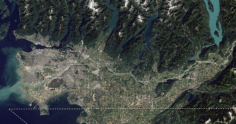
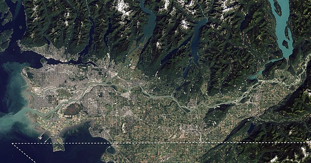
English: I took NASA's beautiful satellite image of the Fraser Lowland from 2012 and cropped into the core area of the Lower Mainland. I also added an approximate Canada-US border line meant for visual reference. This image is meant to replace an older satellite image that outlining the Lower Mainland in red. |
| తేదీ | |
| మూలం | The Big Muddy, Western Edition |
| కర్త | NASA Goddard Space Flight Center from Greenbelt, MD, USA |
| ఇతర కూర్పులు |
.jpg) |
లైసెన్సింగ్
| This image, originally posted to Flickr, was reviewed on 6 September 2020 by the administrator or reviewer Leoboudv, who confirmed that it was available on Flickr under the stated license on that date. |
ఈ దస్త్రం క్రియేటివ్ కామన్స్ ఆపాదింపు 2.0 సాధారణ లైసెన్సు క్రింద లభ్యం.
- ఇలా చేసేందుకు మీకు స్వేచ్ఛ ఉంది:
- పంచుకోడానికి – ఈ కృతిని కాపీ చేసుకోవచ్చు, పంపిణీ చేయవచ్చు, ప్రసారమూ చేయవచ్చు
- రీమిక్స్ చేయడానికి – కృతిని అనుకరించడానికి
- క్రింది షరతులకు లోబడి:
- ఆపాదింపు – సముచితమైన శ్రేయస్సును ఇవ్వాలి, లైసెన్సుకు లింకు ఇవ్వాలి, మార్పులేమైనా చేస్తే వాటిని సూచించాలి. అందుకు సముచితమైన పద్ధతి దేన్నైనా అవలంబించవచ్చు. కానీ మీకూ మీ వాడుకకూ హక్కుదారు అనుమతించారు అనే అర్థం వచ్చేటట్లుగా మాత్రం కాదు.
| Annotations | This image is annotated: View the annotations at Commons |
ఫైలు చరితం
తేదీ/సమయం ను నొక్కి ఆ సమయాన ఫైలు ఎలా ఉండేదో చూడవచ్చు.
| తేదీ/సమయం | నఖచిత్రం | కొలతలు | వాడుకరి | వ్యాఖ్య | |
|---|---|---|---|---|---|
| ప్రస్తుత | 23:14, 4 సెప్టెంబరు 2020 | | 4,200 × 2,200 (3.01 MB) | Ponderosapine210 | Uploaded a work by [https://www.flickr.com/people/24662369@N07 NASA Goddard Space Flight Center] from Greenbelt, MD, USA from [https://www.flickr.com/photos/gsfc/6987590721/ The Big Muddy, Western Edition] with UploadWizard |
లింకులు
కింది పేజీలలో ఈ ఫైలుకు లింకులు ఉన్నాయి:
సార్వత్రిక ఫైలు వాడుక
ఈ దస్త్రాన్ని ఈ క్రింది ఇతర వికీలు ఉపయోగిస్తున్నాయి:
- ca.wikipedia.org లో వాడుక
- en.wikipedia.org లో వాడుక
- eo.wikipedia.org లో వాడుక
- es.wikipedia.org లో వాడుక
- fa.wikipedia.org లో వాడుక
- fy.wikipedia.org లో వాడుక
- it.wikivoyage.org లో వాడుక
- uk.wikipedia.org లో వాడుక
- www.wikidata.org లో వాడుక
- zh.wikipedia.org లో వాడుక