దస్త్రం:Map of Jalaun.png
Jump to navigation
Jump to search
ఈ మునుజూపు పరిమాణం: 718 × 599 పిక్సెళ్ళు. ఇతర రిజల్యూషన్లు: 288 × 240 పిక్సెళ్ళు | 575 × 480 పిక్సెళ్ళు | 920 × 768 పిక్సెళ్ళు | 1,030 × 860 పిక్సెళ్ళు.
అసలు దస్త్రం (1,030 × 860 పిక్సెళ్ళు, ఫైలు పరిమాణం: 12 KB, MIME రకం: image/png)
This is a file from the Wikimedia Commons. Information from its description page there is shown below. Commons is a freely licensed media file repository. You can help. |
సారాంశం
| వివరణ |
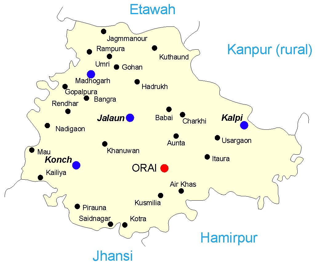
English: Map of the Jalaun district of India. I recreated this in CorelDRAW – the original was in IFC and had no information on its source. I hope I can license this under GFDL though it's derived from :Image:Map-jalaun.gif.
Legend:
sarnam pal orai
|
| తేదీ | 28 సెప్టెంబరు 2005 (original upload date) |
| మూలం | Transferred from en.wikipedia to Commons. |
| కర్త | Mysid at ఇంగ్లీష్ వికీపీడియా |
లైసెన్సింగ్
Mysid from en.wikipedia.org, ఈ కృతి యొక్క కాపీహక్కుదారు, దీన్ని ఇందుమూలముగా ఈ లైసెన్సు క్రింద ప్రచురిస్తున్నారు:
| ఈ దస్త్రం క్రియేటివ్ కామన్స్ Attribution-Share Alike 3.0 Unported లైసెన్సు క్రింద లభ్యం. Subject to disclaimers. | ||
| ఆపాదింపు: Mysid from en.wikipedia.org | ||
| ||
| GFDL లైసెన్సు తాజాకరణలో భాగంగా ఈ దస్త్రానికి ఈ లైసెన్సింగు ట్యాగుని చేర్చారు. |

|
ఈ కృతి యొక్క కర్తనైన నేను, ఇక నుండీ ఈ కృతిని కాపీ చేసుకోవడానికి, పంచి పెట్టడానికి మరియు/లేదా మార్పులు-చేర్పులు చేసుకోవడానికి GFDL, లైసెన్సు వెర్షను 1.2 లేదా దాని తరువాత స్వేచ్చా సాఫ్టువేరు ఫౌండేషను విడుదలచేసే ఏ GFDL లైసెన్సు ద్వారా నయినా అనుమతి ఇస్తున్నాను; ఈ కృతిలో మార్చకూడని బాగాలు లేవు, Front-Cover పాఠం లేదు, Back-Cover పాఠం లేదు. ఈ లైసెన్సు యొక్క పత్రం నకలును "జిఎన్యూ ఉచిత డాక్యుమెంటేషను లైసెన్సు" అని పిలుస్తున్న విభాగంలో ఉంది. Subject to disclaimers. |
అసలు ఎక్కింపుల చిట్టా
The original description page was here. All following user names refer to en.wikipedia.
- 2005-10-03 06:50 Mysid 1030×860× (12045 bytes) Gohan was missing
- 2005-09-28 11:53 Mysid 1000×817× (10442 bytes) Map of the [[Jalaun district]] of [[India]]. I recreated this in CorelDRAW – the original was in IFC and had no information on its source. I hope I can license this under GFDL though it's derived from [[:Image:Map-jalaun.gif]].
ఫైలు చరితం
తేదీ/సమయం ను నొక్కి ఆ సమయాన ఫైలు ఎలా ఉండేదో చూడవచ్చు.
| తేదీ/సమయం | నఖచిత్రం | కొలతలు | వాడుకరి | వ్యాఖ్య | |
|---|---|---|---|---|---|
| ప్రస్తుత | 14:05, 11 మే 2014 | | 1,030 × 860 (12 KB) | Rcbutcher | Transferred from en.wikipedia |
లింకులు
కింది పేజీలలో ఈ ఫైలుకు లింకులు ఉన్నాయి:
సార్వత్రిక ఫైలు వాడుక
ఈ దస్త్రాన్ని ఈ క్రింది ఇతర వికీలు ఉపయోగిస్తున్నాయి:
- ar.wikipedia.org లో వాడుక
- arz.wikipedia.org లో వాడుక
- bn.wikipedia.org లో వాడుక
- ca.wikipedia.org లో వాడుక
- ceb.wikipedia.org లో వాడుక
- en.wikipedia.org లో వాడుక
- es.wikipedia.org లో వాడుక
- nl.wikipedia.org లో వాడుక
- sat.wikipedia.org లో వాడుక
- sv.wikipedia.org లో వాడుక
- tl.wikipedia.org లో వాడుక
- vi.wikipedia.org లో వాడుక
- www.wikidata.org లో వాడుక
- zh-min-nan.wikipedia.org లో వాడుక
- zh.wikipedia.org లో వాడుక