దస్త్రం:OxfordshireOxford.png
Jump to navigation
Jump to search
మరింత స్పష్టమైన బొమ్మ లేదు.
OxfordshireOxford.png (200 × 267 పిక్సెళ్ళు, ఫైలు పరిమాణం: 17 KB, MIME రకం: image/png)
This is a file from the Wikimedia Commons. Information from its description page there is shown below. Commons is a freely licensed media file repository. You can help. |
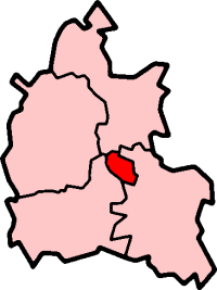
Oxford in Oxfordshire
Created by en:User:Morwen

|
ఈ కృతి యొక్క కర్తనైన నేను, ఇక నుండీ ఈ కృతిని కాపీ చేసుకోవడానికి, పంచి పెట్టడానికి మరియు/లేదా మార్పులు-చేర్పులు చేసుకోవడానికి GFDL, లైసెన్సు వెర్షను 1.2 లేదా దాని తరువాత స్వేచ్చా సాఫ్టువేరు ఫౌండేషను విడుదలచేసే ఏ GFDL లైసెన్సు ద్వారా నయినా అనుమతి ఇస్తున్నాను; ఈ కృతిలో మార్చకూడని బాగాలు లేవు, Front-Cover పాఠం లేదు, Back-Cover పాఠం లేదు. ఈ లైసెన్సు యొక్క పత్రం నకలును "జిఎన్యూ ఉచిత డాక్యుమెంటేషను లైసెన్సు" అని పిలుస్తున్న విభాగంలో ఉంది. |
| ఈ దస్త్రం క్రియేటివ్ కామన్స్ Attribution-Share Alike 3.0 Unported లైసెన్సు క్రింద లభ్యం. | ||
| ||
| GFDL లైసెన్సు తాజాకరణలో భాగంగా ఈ దస్త్రానికి ఈ లైసెన్సింగు ట్యాగుని చేర్చారు. |
ఫైలు చరితం
తేదీ/సమయం ను నొక్కి ఆ సమయాన ఫైలు ఎలా ఉండేదో చూడవచ్చు.
| తేదీ/సమయం | నఖచిత్రం | కొలతలు | వాడుకరి | వ్యాఖ్య | |
|---|---|---|---|---|---|
| ప్రస్తుత | 09:55, 27 సెప్టెంబరు 2005 | | 200 × 267 (17 KB) | Voyager | City of Oxford shown within Oxfordshire Map by en:User:Morwen Category:Maps of England |
లింకులు
ఈ ఫైలును వాడుతున్న పేజీలు లేవు.
సార్వత్రిక ఫైలు వాడుక
ఈ దస్త్రాన్ని ఈ క్రింది ఇతర వికీలు ఉపయోగిస్తున్నాయి:
- azb.wikipedia.org లో వాడుక
- en.wikipedia.org లో వాడుక
- Oxford
- Iffley
- Marston, Oxford
- Cowley, Oxfordshire
- Wolvercote
- Oxford East (UK Parliament constituency)
- Oxford West and Abingdon (UK Parliament constituency)
- Littlemore
- Port Meadow, Oxford
- Headington
- Blackbird Leys
- Risinghurst
- Grandpont
- Oxford (UK Parliament constituency)
- Jericho, Oxford
- Risinghurst and Sandhills
- Oxford City Council elections
- North Oxford
- Park Town, Oxford
- New Marston
- Cutteslowe
- Binsey, Oxfordshire
- Godstow
- Headington Rural District
- Osney
- Summertown, Oxford
- St Clement's, Oxford
- Headington Hill
- Rose Hill, Oxfordshire
- New Hinksey
- Hinksey
- Sunnymead
- Barton, Oxfordshire
- Donnington, Oxfordshire
- St. Ebbes
- Oxfordshire (UK Parliament constituency)
- Walton Manor
- Norham Manor
- Oxpens Road
- Template:Oxford
- User:Rst20xx/Contributions and Awards
- St John Street area
- Holywell, Oxford
- Northway, Oxford
- Waterways, Oxford
- Wood Farm, Oxfordshire
ఈ దస్త్రపు మరింత సార్వత్రిక వాడుకను చూడండి.