దస్త్రం:Urbanized population 2006.png
Jump to navigation
Jump to search

ఈ మునుజూపు పరిమాణం: 800 × 364 పిక్సెళ్ళు. ఇతర రిజల్యూషన్లు: 320 × 146 పిక్సెళ్ళు | 640 × 292 పిక్సెళ్ళు | 1,024 × 466 పిక్సెళ్ళు | 1,280 × 583 పిక్సెళ్ళు | 3,600 × 1,640 పిక్సెళ్ళు.
అసలు దస్త్రం (3,600 × 1,640 పిక్సెళ్ళు, ఫైలు పరిమాణం: 550 KB, MIME రకం: image/png)
This is a file from the Wikimedia Commons. Information from its description page there is shown below. Commons is a freely licensed media file repository. You can help. |
సారాంశం
| వివరణ |
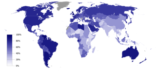
English: Urbanized population percentage by country as of 2006. Source: UNICEF, The State of the World’s Children 2008 (p. 134)
This map was created with GunnMap GunnMap was created by Arthur Gunn and is available, free, at http://gunn.co.nz/map/ and http://gunnmap.herokuapp.com/. Please attribute by linking to http://gunn.co.nz/map/. |
| తేదీ | |
| మూలం | Based on BlankMap-World6, compact.svg by Canuckguy et al. |
| కర్త | Jelle564 |
లైసెన్సింగ్
| నేను, ఈ కృతి యొక్క కాపీహక్కుదారుని, ఈ కృతిని సార్వజనీనం'గా విడుదల చేస్తున్నాను. ఇది ప్రపంచవ్యాప్తంగా వర్తిస్తుంది. కొన్ని దేశాల్లో ఇది చట్టబద్ధంగా సాధ్యంకాకపోవచ్చు; అయితే: ఈ కృతిని ఎటువంటి షరతులు లేకుండా, అట్టి షరతులు చట్టం వల్ల తప్పనిసరి అయితే తప్ప, ఏ ఉద్దేశానికైనా ఉపయోగించుకునే హక్కును ఎవరికైనా నేను ప్రదానం చేస్తున్నాను. |
ఫైలు చరితం
తేదీ/సమయం ను నొక్కి ఆ సమయాన ఫైలు ఎలా ఉండేదో చూడవచ్చు.
| తేదీ/సమయం | నఖచిత్రం | కొలతలు | వాడుకరి | వ్యాఖ్య | |
|---|---|---|---|---|---|
| ప్రస్తుత | 13:41, 19 ఫిబ్రవరి 2017 | | 3,600 × 1,640 (550 KB) | Zywang114072 | Change and update country urbanized population degree color: Taiwan |
| 16:48, 16 జనవరి 2009 |  | 3,600 × 1,640 (362 KB) | Jelle564 | {{Information |Description={{en|1=Urbanized population percentage by country as of 2006. Source: http://www.unicef.org/sowc08/docs/sowc08_table_StatisticalTables.pdf {{GunnMap}}}} |Source=Based on [[:Image:BlankMap-World6, compact.svg|BlankMap-World6, com |
లింకులు
ఈ ఫైలును వాడుతున్న పేజీలు లేవు.
సార్వత్రిక ఫైలు వాడుక
ఈ దస్త్రాన్ని ఈ క్రింది ఇతర వికీలు ఉపయోగిస్తున్నాయి:
- ar.wikipedia.org లో వాడుక
- bg.wikipedia.org లో వాడుక
- ca.wikipedia.org లో వాడుక
- es.wikipedia.org లో వాడుక
- fa.wikipedia.org లో వాడుక
- gu.wikipedia.org లో వాడుక
- it.wikipedia.org లో వాడుక
- ka.wikipedia.org లో వాడుక
- la.wikipedia.org లో వాడుక
- lt.wikipedia.org లో వాడుక
- nl.wikipedia.org లో వాడుక
- nn.wikipedia.org లో వాడుక
- no.wikipedia.org లో వాడుక
- pl.wikipedia.org లో వాడుక
- pt.wikipedia.org లో వాడుక
- ta.wikipedia.org లో వాడుక
- ur.wikipedia.org లో వాడుక