దస్త్రం:Bohaiseamap2.png

వికీపీడియా నుండి
Jump to navigation Jump to search

Bohaiseamap2.png(569 × 487 పిక్సెళ్ళు, ఫైలు పరిమాణం: 136 KB, MIME రకం: image/png)

Warning sign This file requires updating because: I suggest using the more normative 'Pyongyang' and 'Yellow River' or at least adding these forms in parentheses. In doing so, you could add a timestamp to the file.
Please notify the uploader with {{subst:update-note|1=File:Bohaiseamap2.png|2=I suggest using the more normative 'Pyongyang' and 'Yellow River' or at least adding these forms in parentheses.}} ~~~~

సారాంశం

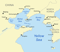
వివరణ Map of the Bohai Sea and surrounding bays. For a more general map of the same area see Image:Bohai Sea map.png
తేదీ
మూలం self-made, based on DCW data.
కర్త Kmusser
ఇతర కూర్పులు

Derivative works of this file:

This map image could be re-created using vector graphics as an SVG file. This has several advantages; see Commons:Media for cleanup for more information. If an SVG form of this image is available, please upload it and afterwards replace this template with {{vector version available|new image name}}.


It is recommended to name the SVG file “Bohaiseamap2.svg”—then the template Vector version available (or Vva) does not need the new image name parameter.

లైసెన్సింగ్

నేను, ఈ కృతి యొక్క కాపీహక్కుదారుని, దీన్ని ఈ లైసెన్సు క్రింద ఇందుమూలముగా ప్రచురిస్తున్నాను:
w:en:Creative Commons
ఆపాదింపు share alike
ఇలా చేసేందుకు మీకు స్వేచ్ఛ ఉంది:
  • పంచుకోడానికి – ఈ కృతిని కాపీ చేసుకోవచ్చు, పంపిణీ చేయవచ్చు, ప్రసారమూ చేయవచ్చు
  • రీమిక్స్ చేయడానికి – కృతిని అనుకరించడానికి
క్రింది షరతులకు లోబడి:
  • ఆపాదింపు – సముచితమైన శ్రేయస్సును ఇవ్వాలి, లైసెన్సుకు లింకు ఇవ్వాలి, మార్పులేమైనా చేస్తే వాటిని సూచించాలి. అందుకు సముచితమైన పద్ధతి దేన్నైనా అవలంబించవచ్చు. కానీ మీకూ మీ వాడుకకూ హక్కుదారు అనుమతించారు అనే అర్థం వచ్చేటట్లుగా మాత్రం కాదు.
  • share alike – మీరు ఈ కృతిని అనుకరిస్తే, మారిస్తే, లేదా మెరుగుపరిస్తే తత్ఫలిత కృతిని ఇదే లైసెన్సు లేదా దీనికి అనుగుణ్యమైన లైసెన్సు క్రింద మాత్రమే పంపిణీ చేయాలి.

Captions

Add a one-line explanation of what this file represents
Map of the Bohai Sea and surrounding bays

Items portrayed in this file

చిత్రణ

Bohai Sea ఇంగ్లీష్

copyright status ఇంగ్లీష్

copyrighted ఇంగ్లీష్

MIME type ఇంగ్లీష్

image/png

checksum ఇంగ్లీష్

e776fb894d1db142a63c8f0d600c8d6c18de759c

data size ఇంగ్లీష్

1,39,100 బైట్

487 చిణువు

569 చిణువు

ఫైలు చరితం

తేదీ/సమయం ను నొక్కి ఆ సమయాన ఫైలు ఎలా ఉండేదో చూడవచ్చు.

తేదీ/సమయంనఖచిత్రంకొలతలువాడుకరివ్యాఖ్య
ప్రస్తుత19:33, 7 జనవరి 202119:33, 7 జనవరి 2021 నాటి కూర్పు నఖచిత్రం569 × 487 (136 KB)Ras67black frame cropped and alpha channel removed
14:59, 27 జూన్ 200714:59, 27 జూన్ 2007 నాటి కూర్పు నఖచిత్రం583 × 500 (179 KB)Kmusseradded strait
14:50, 27 జూన్ 200714:50, 27 జూన్ 2007 నాటి కూర్పు నఖచిత్రం500 × 429 (141 KB)Kmusser{{Information |Description=Map of the Bohai Sea and surrounding bays. For a more general map of the same area see Image:Bohai Sea map.png |Source=self-made, based on DCW data. |Date=June 27, 2007

కింది పేజీలలో ఈ ఫైలుకు లింకులు ఉన్నాయి:

సార్వత్రిక ఫైలు వాడుక

ఈ దస్త్రాన్ని ఈ క్రింది ఇతర వికీలు ఉపయోగిస్తున్నాయి:

ఈ దస్త్రపు మరింత సార్వత్రిక వాడుకను చూడండి.

మెటాడేటా

"https://te.wikipedia.org/wiki/దస్త్రం:Bohaiseamap2.png" నుండి వెలికితీశారు