Jump to content

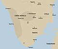
దస్త్రం:Chera country (early historic south India).jpg

ఈ పేజీ లోని కంటెంటులకు ఇతర భాషలలో మద్దతు లేదు.
వికీపీడియా నుండి

అసలు దస్త్రం (2,670 × 2,219 పిక్సెళ్ళు, ఫైలు పరిమాణం: 878 KB, MIME రకం: image/jpeg)

సారాంశం

వివరణ
English: An approximate representation of the extent of Chera country in early historic south India
  • Source: 'Antecedents of the State Formation in Early South India' by Rajan Gurukkal in State and society in pre-modern South India
తేదీ
మూలం స్వంత కృతి
కర్త Adapted from the maps by Y. Subbarayalu for Rajan Gurukkal
ఇతర కూర్పులు
This map image could be re-created using vector graphics as an SVG file. This has several advantages; see Commons:Media for cleanup for more information. If an SVG form of this image is available, please upload it and afterwards replace this template with {{vector version available|new image name}}.


It is recommended to name the SVG file “Chera country (early historic south India).svg”—then the template Vector version available (or Vva) does not need the new image name parameter.

లైసెన్సింగ్

నేను, ఈ కృతి యొక్క కాపీహక్కుదారుని, దీన్ని ఈ లైసెన్సు క్రింద ఇందుమూలముగా ప్రచురిస్తున్నాను:
w:en:Creative Commons
ఆపాదింపు share alike
This file is licensed under the Creative Commons Attribution-Share Alike 4.0 International license.
ఇలా చేసేందుకు మీకు స్వేచ్ఛ ఉంది:
  • పంచుకోడానికి – ఈ కృతిని కాపీ చేసుకోవచ్చు, పంపిణీ చేయవచ్చు, ప్రసారమూ చేయవచ్చు
  • రీమిక్స్ చేయడానికి – కృతిని అనుకరించడానికి
క్రింది షరతులకు లోబడి:
  • ఆపాదింపు – సముచితమైన శ్రేయస్సును ఇవ్వాలి, లైసెన్సుకు లింకు ఇవ్వాలి, మార్పులేమైనా చేస్తే వాటిని సూచించాలి. అందుకు సముచితమైన పద్ధతి దేన్నైనా అవలంబించవచ్చు. కానీ మీకూ మీ వాడుకకూ హక్కుదారు అనుమతించారు అనే అర్థం వచ్చేటట్లుగా మాత్రం కాదు.
  • share alike – మీరు ఈ కృతిని అనుకరిస్తే, మారిస్తే, లేదా మెరుగుపరిస్తే తత్ఫలిత కృతిని ఇదే లైసెన్సు లేదా దీనికి అనుగుణ్యమైన లైసెన్సు క్రింద మాత్రమే పంపిణీ చేయాలి.

Captions

Add a one-line explanation of what this file represents
Approximate representation of the extent of Chera Kingdom

Items portrayed in this file

చిత్రణ

source of file ఇంగ్లీష్

original creation by uploader ఇంగ్లీష్

media type ఇంగ్లీష్

image/jpeg

checksum ఇంగ్లీష్

1bdff91b653e10a00139e94b95a454f048a22a7f

data size ఇంగ్లీష్

8,99,241 బైట్

2,219 చిణువు

2,670 చిణువు

ఫైలు చరితం

తేదీ/సమయం ను నొక్కి ఆ సమయాన ఫైలు ఎలా ఉండేదో చూడవచ్చు.

తేదీ/సమయంనఖచిత్రంకొలతలువాడుకరివ్యాఖ్య
ప్రస్తుత05:45, 20 మార్చి 202005:45, 20 మార్చి 2020 నాటి కూర్పు నఖచిత్రం2,670 × 2,219 (878 KB)StephenPaaAdded terrain
13:45, 4 ఫిబ్రవరి 202013:45, 4 ఫిబ్రవరి 2020 నాటి కూర్పు నఖచిత్రం2,670 × 2,219 (775 KB)StephenPaaAdded boundaries from ''State and Society in Pre-modern South India'' (Rajan Gurukkal)
02:19, 9 జూలై 201902:19, 9 జూలై 2019 నాటి కూర్పు నఖచిత్రం2,000 × 1,333 (176 KB)TimdwilliamsonUser created page with UploadWizard

కింది పేజీలలో ఈ ఫైలుకు లింకులు ఉన్నాయి:

సార్వత్రిక ఫైలు వాడుక

ఈ దస్త్రాన్ని ఈ క్రింది ఇతర వికీలు ఉపయోగిస్తున్నాయి:

మెటాడేటా