దస్త్రం:Countries that use Fahrenheit.svg
Jump to navigation
Jump to search

ఈ ఫైలు SVG కు చెందిన ఈ మునుజూపు PNG పరిమాణం: 800 × 411 పిక్సెళ్ళు. ఇతర రిజల్యూషన్లు: 320 × 164 పిక్సెళ్ళు | 640 × 329 పిక్సెళ్ళు | 1,024 × 526 పిక్సెళ్ళు | 1,280 × 657 పిక్సెళ్ళు | 2,560 × 1,314 పిక్సెళ్ళు.
అసలు దస్త్రం (SVG ఫైలు, నామమాత్రంగా 2,560 × 1,314 పిక్సెళ్ళు, ఫైలు పరిమాణం: 1.05 MB)
This is a file from the Wikimedia Commons. Information from its description page there is shown below. Commons is a freely licensed media file repository. You can help. |
సారాంశం
| వివరణ |
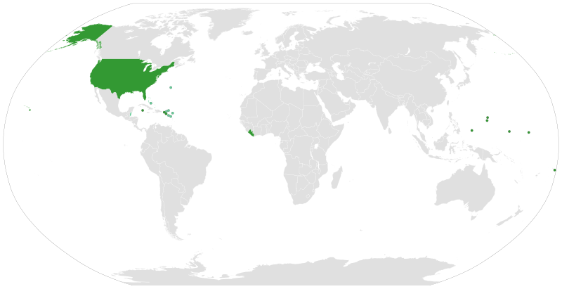
English: Use of the Fahrenheit system of measuring temperatures
Countries which officially use Fahrenheit
Countries which use both systems at the same time
Countries which officially use Celsius Italiano: Uso della scala termometrica Fahrenheit
Paesi che usano ufficialmente la scala Fahrenheit
Paesi che usano entrambe le scale
Paesi che usano ufficialmente la scala Celsius Nederlands: Gebruik van de Fahrenheit-schaal om temperaturen te meten
Landen die de Fahrenheit-schaal gebruiken
Landen die allebei de schalen gebruiken
Landen die de Celsius-schaal gebruiken Svenska: Användandet av Fahrenheit-systemet för mätning av temperatur
Länder använder sig av Fahrenheit
Länder som använder båda systemen
Länder använder sig av Celsius |
| తేదీ | |
| మూలం |
This vector image includes elements that have been taken or adapted from this file: |
| కర్త |
|
| SVG పెరుగుదల | This vector image was created with a text editor. |
లైసెన్సింగ్
నేను, ఈ కృతి యొక్క కాపీహక్కుదారుని, దీన్ని ఈ లైసెన్సు క్రింద ఇందుమూలముగా ప్రచురిస్తున్నాను:
This file is licensed under the Creative Commons Attribution-Share Alike 4.0 International license.
- ఇలా చేసేందుకు మీకు స్వేచ్ఛ ఉంది:
- పంచుకోడానికి – ఈ కృతిని కాపీ చేసుకోవచ్చు, పంపిణీ చేయవచ్చు, ప్రసారమూ చేయవచ్చు
- రీమిక్స్ చేయడానికి – కృతిని అనుకరించడానికి
- క్రింది షరతులకు లోబడి:
- ఆపాదింపు – సముచితమైన శ్రేయస్సును ఇవ్వాలి, లైసెన్సుకు లింకు ఇవ్వాలి, మార్పులేమైనా చేస్తే వాటిని సూచించాలి. అందుకు సముచితమైన పద్ధతి దేన్నైనా అవలంబించవచ్చు. కానీ మీకూ మీ వాడుకకూ హక్కుదారు అనుమతించారు అనే అర్థం వచ్చేటట్లుగా మాత్రం కాదు.
- share alike – మీరు ఈ కృతిని అనుకరిస్తే, మారిస్తే, లేదా మెరుగుపరిస్తే తత్ఫలిత కృతిని ఇదే లైసెన్సు లేదా దీనికి అనుగుణ్యమైన లైసెన్సు క్రింద మాత్రమే పంపిణీ చేయాలి.
ఫైలు చరితం
తేదీ/సమయం ను నొక్కి ఆ సమయాన ఫైలు ఎలా ఉండేదో చూడవచ్చు.
| తేదీ/సమయం | నఖచిత్రం | కొలతలు | వాడుకరి | వ్యాఖ్య | |
|---|---|---|---|---|---|
| ప్రస్తుత | 11:39, 29 డిసెంబరు 2019 | | 2,560 × 1,314 (1.05 MB) | Carnby | Updated Turks and Caicos |
| 17:43, 10 జూలై 2019 |  | 2,560 × 1,314 (1.05 MB) | Carnby | Updated Bahamas | |
| 18:22, 1 అక్టోబరు 2018 |  | 2,560 × 1,314 (1.05 MB) | Carnby | Belize now uses both measurement systems | |
| 20:22, 17 సెప్టెంబరు 2018 |  | 2,560 × 1,314 (1.05 MB) | Carnby | Also Turks and Caicos in official weather reports use both Fahrenheit and Celsius | |
| 19:10, 17 సెప్టెంబరు 2018 |  | 2,560 × 1,314 (1.05 MB) | Carnby | Also Turks and Caicos Islands use Fahrenheit; Bermuda, Antigua and Barbuda and other islands which use the same meteorological service (Anguilla, British Virgin Islands, Montserrat and Saint Kitts and Nevis) use both Fahrenheit and Celsius | |
| 17:23, 17 సెప్టెంబరు 2018 |  | 2,560 × 1,314 (1.05 MB) | Carnby | British West Indies still use Fahrenheit (although Bermuda uses also Celsius) | |
| 15:06, 16 సెప్టెంబరు 2018 |  | 2,560 × 1,314 (1.05 MB) | Carnby | Updated; Myanmar uses Celsius now; circles around small countries (if you want to revert please write me first) | |
| 16:03, 1 ఫిబ్రవరి 2018 |  | 1,650 × 750 (748 KB) | TysonB15 | Reverted to version as of 16:48, 19 January 2016 (UTC) due to higher resolution, transparency, and shading of regions instead of green dots. | |
| 20:25, 28 డిసెంబరు 2016 |  | 940 × 415 (1.45 MB) | Carnby | Reverted to version as of 19:45, 28 December 2016 (UTC) | |
| 20:23, 28 డిసెంబరు 2016 |  | 940 × 415 (1.45 MB) | Carnby | Belize |
లింకులు
కింది పేజీలలో ఈ ఫైలుకు లింకులు ఉన్నాయి:
సార్వత్రిక ఫైలు వాడుక
ఈ దస్త్రాన్ని ఈ క్రింది ఇతర వికీలు ఉపయోగిస్తున్నాయి:
- af.wikipedia.org లో వాడుక
- an.wikipedia.org లో వాడుక
- ar.wikipedia.org లో వాడుక
- ast.wikipedia.org లో వాడుక
- az.wikipedia.org లో వాడుక
- be-tarask.wikipedia.org లో వాడుక
- be.wikipedia.org లో వాడుక
- bg.wikipedia.org లో వాడుక
- ca.wikipedia.org లో వాడుక
- cs.wikipedia.org లో వాడుక
- da.wikipedia.org లో వాడుక
- el.wikipedia.org లో వాడుక
- en.wikipedia.org లో వాడుక
- eo.wikipedia.org లో వాడుక
- es.wikipedia.org లో వాడుక
- eu.wikipedia.org లో వాడుక
- fa.wikipedia.org లో వాడుక
- fi.wikipedia.org లో వాడుక
- fo.wikipedia.org లో వాడుక
- frr.wikipedia.org లో వాడుక
- fr.wikipedia.org లో వాడుక
- fy.wikipedia.org లో వాడుక
- gl.wikipedia.org లో వాడుక
- he.wikipedia.org లో వాడుక
- hi.wikipedia.org లో వాడుక
- hy.wikipedia.org లో వాడుక
- ia.wikipedia.org లో వాడుక
- id.wikipedia.org లో వాడుక
- is.wikipedia.org లో వాడుక
- it.wikipedia.org లో వాడుక
- jam.wikipedia.org లో వాడుక
- ja.wikipedia.org లో వాడుక
- ka.wikipedia.org లో వాడుక
- kn.wikipedia.org లో వాడుక
- ko.wikipedia.org లో వాడుక
- ku.wikipedia.org లో వాడుక
- lb.wikipedia.org లో వాడుక
- lv.wikipedia.org లో వాడుక
- mk.wikipedia.org లో వాడుక
- ml.wikipedia.org లో వాడుక
- mr.wikipedia.org లో వాడుక
- ms.wikipedia.org లో వాడుక
ఈ దస్త్రపు మరింత సార్వత్రిక వాడుకను చూడండి.