దస్త్రం:India Karnataka COVID-19 map.svg
Jump to navigation
Jump to search

ఈ ఫైలు SVG కు చెందిన ఈ మునుజూపు PNG పరిమాణం: 415 × 600 పిక్సెళ్ళు. ఇతర రిజల్యూషన్లు: 166 × 240 పిక్సెళ్ళు | 332 × 480 పిక్సెళ్ళు | 531 × 768 పిక్సెళ్ళు | 708 × 1,024 పిక్సెళ్ళు | 1,417 × 2,048 పిక్సెళ్ళు | 1,630 × 2,356 పిక్సెళ్ళు.
అసలు దస్త్రం (SVG ఫైలు, నామమాత్రంగా 1,630 × 2,356 పిక్సెళ్ళు, ఫైలు పరిమాణం: 260 KB)
This is a file from the Wikimedia Commons. Information from its description page there is shown below. Commons is a freely licensed media file repository. You can help. |
సారాంశం
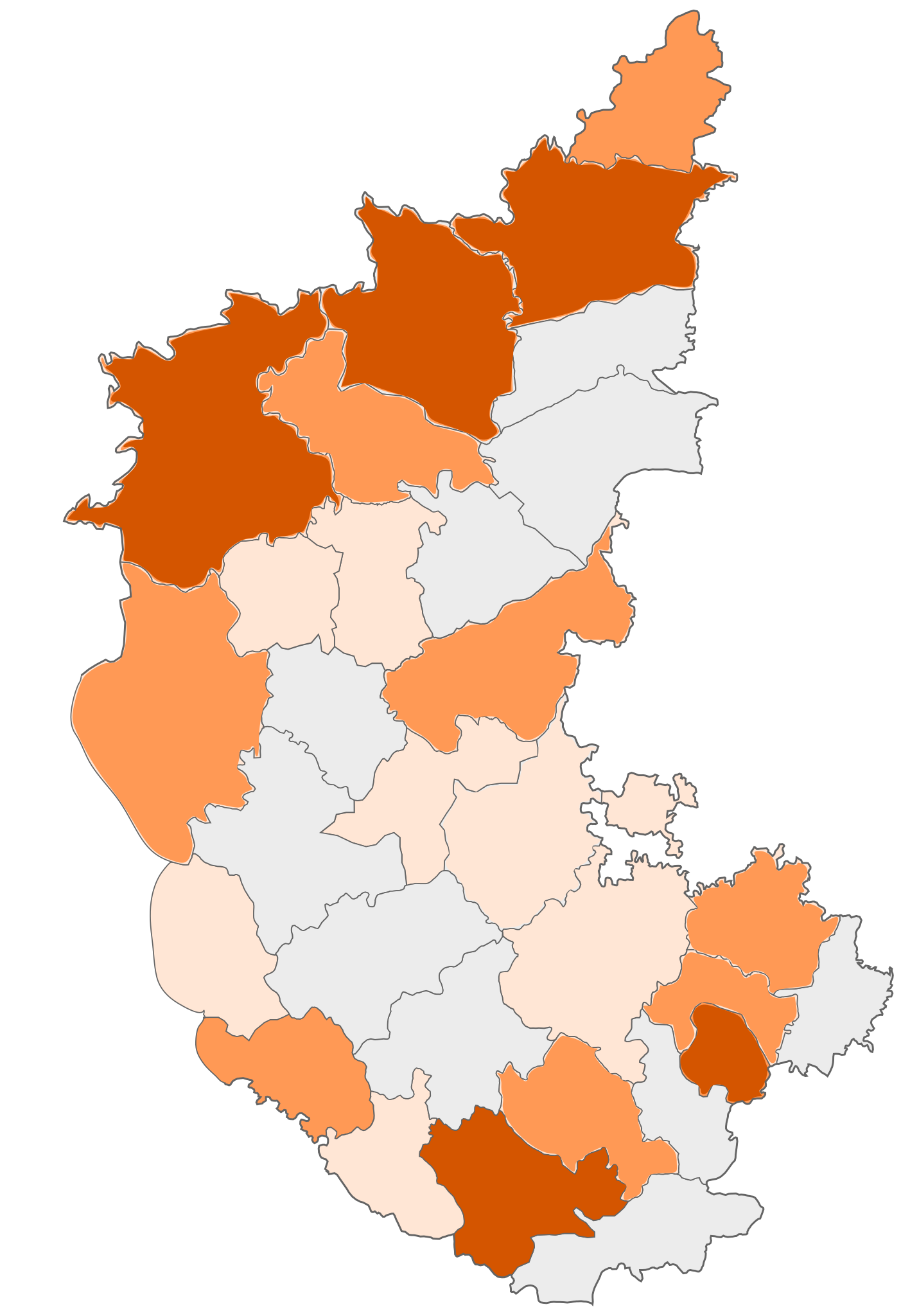
| వివరణ | COVID-19 affected districts in Karnataka state of India as of 7 April 2020. |
| తేదీ | (UTC) |
| మూలం |
This file was derived from: |
| కర్త | Firos ak |


| This is a retouched picture, which means that it has been digitally altered from its original version. Modifications: marking COVID 19 district map. The original can be viewed here: India Karnataka COVID-19 map.png:
|
లైసెన్సింగ్
ఈ దస్త్రం క్రియేటివ్ కామన్స్ Attribution-Share Alike 3.0 Unported లైసెన్సు క్రింద లభ్యం.
- ఇలా చేసేందుకు మీకు స్వేచ్ఛ ఉంది:
- పంచుకోడానికి – ఈ కృతిని కాపీ చేసుకోవచ్చు, పంపిణీ చేయవచ్చు, ప్రసారమూ చేయవచ్చు
- రీమిక్స్ చేయడానికి – కృతిని అనుకరించడానికి
- క్రింది షరతులకు లోబడి:
- ఆపాదింపు – సముచితమైన శ్రేయస్సును ఇవ్వాలి, లైసెన్సుకు లింకు ఇవ్వాలి, మార్పులేమైనా చేస్తే వాటిని సూచించాలి. అందుకు సముచితమైన పద్ధతి దేన్నైనా అవలంబించవచ్చు. కానీ మీకూ మీ వాడుకకూ హక్కుదారు అనుమతించారు అనే అర్థం వచ్చేటట్లుగా మాత్రం కాదు.
- share alike – మీరు ఈ కృతిని అనుకరిస్తే, మారిస్తే, లేదా మెరుగుపరిస్తే తత్ఫలిత కృతిని ఇదే లైసెన్సు లేదా దీనికి అనుగుణ్యమైన లైసెన్సు క్రింద మాత్రమే పంపిణీ చేయాలి.
అసలు ఎక్కింపుల చిట్టా
This image is a derivative work of the following images:
- File:India Karnataka location map.svg licensed with Cc-by-sa-3.0
- 2010-11-15T15:50:48Z Nayvik 1630x2356 (211689 Bytes) Changed background color
- 2010-11-15T15:34:13Z Nayvik 1630x2356 (211293 Bytes) {{Information |Description=Location map of [[:en:Karnataka|Karnataka]] Geographic limits of the map: * 18.5°N * 11.0°N * 73.6°E * 78.7°E |Source=*[[:File:Karnataka_locator_map.svg|]], [http://www.censusindia.gov.in/2011-I
- File:Karnataka locator map.svg licensed with Cc-by-sa-3.0
- 2010-11-20T10:48:54Z Nayvik 1630x2356 (240130 Bytes) Created 3 new districts [[:en:Chikballapur district|Chikballapur district]], [[:en:Ramanagara district|Ramanagara district]] and [[:en:Yadgir district|Yadgir district]]
- 2007-05-08T10:07:08Z Planemad 1630x2356 (231256 Bytes) chg color of chamarajanagar
- 2007-05-06T13:55:02Z Planemad 1630x2356 (231773 Bytes) {{WikiProject_India_Maps |Title=Karnataka locator Map |Description=Map of [[w:Karnataka]] with road and rail lines |Source= [http://aquarium.lipetsk.ru/discovery/India2004/karnataka-map.jpg Karnataka Map], [http://www.indianr
- File:India Karnataka COVID-19 map.png licensed with Cc-by-sa-3.0
- 2020-03-21T10:18:11Z Firos ak 1630x2356 (400039 Bytes) Removed Bangalore rural and added Chikballapur Dist.
- 2020-03-21T09:56:47Z Firos ak 1630x2356 (399619 Bytes) Added Bangalore rural
- 2020-03-21T08:17:25Z Firos ak 1630x2356 (397871 Bytes) Added Kodagu district
- 2020-03-17T09:22:44Z Shanze1 2608x3768 (686680 Bytes) fix
- 2020-03-17T09:17:26Z Shanze1 2379x3711 (702913 Bytes) transparency
- 2020-03-17T09:13:51Z Shanze1 1631x2357 (387099 Bytes) == {{int:filedesc}} == {{Information |Description=COVID-19 affected districts in Karnataka state of India as of 17 March 2020. |Source={{Derived from|India Karnataka location map.svg|display=50}} |Date=2020-03-17 09:10 (UTC)
Uploaded with derivativeFX
ఫైలు చరితం
తేదీ/సమయం ను నొక్కి ఆ సమయాన ఫైలు ఎలా ఉండేదో చూడవచ్చు.
| తేదీ/సమయం | నఖచిత్రం | కొలతలు | వాడుకరి | వ్యాఖ్య | |
|---|---|---|---|---|---|
| ప్రస్తుత | 14:27, 23 ఏప్రిల్ 2020 | | 1,630 × 2,356 (260 KB) | Prasannatb | Kalaburagi - 30+ Vijayapura - 30+ |
| 09:48, 17 ఏప్రిల్ 2020 |  | 1,630 × 2,356 (255 KB) | Prasannatb | Mandya - 10+, Ballari - 10+ | |
| 13:53, 16 ఏప్రిల్ 2020 |  | 1,630 × 2,356 (249 KB) | Prasannatb | Belagavi -30+ and Vijayapura - 10+ | |
| 17:11, 14 ఏప్రిల్ 2020 |  | 1,630 × 2,356 (238 KB) | Prasannatb | Chitradurga - 1+ | |
| 17:03, 14 ఏప్రిల్ 2020 |  | 1,630 × 2,356 (235 KB) | Prasannatb | Chikkaballapura, Bengaluru Rural, Uttara Kannada - 10+ | |
| 09:36, 14 ఏప్రిల్ 2020 |  | 1,630 × 2,356 (228 KB) | Prasannatb | Bagalkote - 10+ | |
| 08:31, 12 ఏప్రిల్ 2020 |  | 1,630 × 2,356 (225 KB) | Prasannatb | Vijayapura - +1 | |
| 08:47, 10 ఏప్రిల్ 2020 |  | 1,630 × 2,356 (222 KB) | Prasannatb | Kalaburagi - 10+ | |
| 14:24, 9 ఏప్రిల్ 2020 |  | 1,630 × 2,356 (218 KB) | Prasannatb | Belagavi - 10+ | |
| 15:28, 7 ఏప్రిల్ 2020 |  | 1,630 × 2,356 (212 KB) | Firos ak | 7 apr |
లింకులు
కింది పేజీలలో ఈ ఫైలుకు లింకులు ఉన్నాయి:
సార్వత్రిక ఫైలు వాడుక
ఈ దస్త్రాన్ని ఈ క్రింది ఇతర వికీలు ఉపయోగిస్తున్నాయి:
- en.wikipedia.org లో వాడుక
- kn.wikipedia.org లో వాడుక
- tcy.wikipedia.org లో వాడుక
- tr.wikipedia.org లో వాడుక
- ur.wikipedia.org లో వాడుక
- www.wikidata.org లో వాడుక