దస్త్రం:LocationSaintLucia.png
Jump to navigation
Jump to search
మరింత స్పష్టమైన బొమ్మ లేదు.
LocationSaintLucia.png (250 × 115 పిక్సెళ్ళు, ఫైలు పరిమాణం: 3 KB, MIME రకం: image/png)
This is a file from the Wikimedia Commons. Information from its description page there is shown below. Commons is a freely licensed media file repository. You can help. |
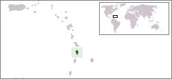
Location map for the Saint Lucia.
Originally created for English Wikipedia by Vardion.
| |
ఈ కృతిని కృతికర్త, Vardion, at the ఇంగ్లీష్ వికీపీడియా project, సార్వజనీనంగా విడుదల చేసారు. ఇది ప్రపంచవ్యాప్తంగా వర్తిస్తుంది. In case this is not legally possible: |

|
This locator map image could be re-created using vector graphics as an SVG file. This has several advantages; see Commons:Media for cleanup for more information. If an SVG form of this image is available, please upload it and afterwards replace this template with
{{vector version available|new image name}}.
It is recommended to name the SVG file “LocationSaintLucia.svg”—then the template Vector version available (or Vva) does not need the new image name parameter. |
ఫైలు చరితం
తేదీ/సమయం ను నొక్కి ఆ సమయాన ఫైలు ఎలా ఉండేదో చూడవచ్చు.
| తేదీ/సమయం | నఖచిత్రం | కొలతలు | వాడుకరి | వ్యాఖ్య | |
|---|---|---|---|---|---|
| ప్రస్తుత | 18:28, 16 జనవరి 2008 | | 250 × 115 (3 KB) | Mahahahaneapneap | pngcrushed |
| 03:03, 20 డిసెంబరు 2004 |  | 250 × 115 (5 KB) | EugeneZelenko | Location map for the Saint Lucia.<br/>Originally created for English Wikipedia by Vardion.<br/>{{PD}}<br/>Category:Country locator maps |
లింకులు
కింది పేజీలలో ఈ ఫైలుకు లింకులు ఉన్నాయి:
సార్వత్రిక ఫైలు వాడుక
ఈ దస్త్రాన్ని ఈ క్రింది ఇతర వికీలు ఉపయోగిస్తున్నాయి:
- ar.wikipedia.org లో వాడుక
- az.wiktionary.org లో వాడుక
- ba.wikipedia.org లో వాడుక
- be-tarask.wikipedia.org లో వాడుక
- be.wikipedia.org లో వాడుక
- bg.wikipedia.org లో వాడుక
- bn.wikipedia.org లో వాడుక
- bo.wikipedia.org లో వాడుక
- bpy.wikipedia.org లో వాడుక
- bs.wikipedia.org లో వాడుక
- ca.wikipedia.org లో వాడుక
- ceb.wikipedia.org లో వాడుక
- ckb.wikipedia.org లో వాడుక
- da.wikipedia.org లో వాడుక
- de.wikivoyage.org లో వాడుక
- de.wiktionary.org లో వాడుక
- el.wiktionary.org లో వాడుక
- en.wikipedia.org లో వాడుక
- en.wikivoyage.org లో వాడుక
- eo.wikipedia.org లో వాడుక
- es.wikipedia.org లో వాడుక
- es.wikinews.org లో వాడుక
- ext.wikipedia.org లో వాడుక
- fa.wikipedia.org లో వాడుక
- fiu-vro.wikipedia.org లో వాడుక
- fo.wikipedia.org లో వాడుక
- frp.wikipedia.org లో వాడుక
- fr.wikipedia.org లో వాడుక
- fy.wikipedia.org లో వాడుక
- gv.wikipedia.org లో వాడుక
- he.wikivoyage.org లో వాడుక
- hif.wikipedia.org లో వాడుక
- hr.wikipedia.org లో వాడుక
- ht.wikipedia.org లో వాడుక
- hu.wikipedia.org లో వాడుక
ఈ దస్త్రపు మరింత సార్వత్రిక వాడుకను చూడండి.