దస్త్రం:Uruguay T2.png
Jump to navigation
Jump to search

ఈ మునుజూపు పరిమాణం: 527 × 599 పిక్సెళ్ళు. ఇతర రిజల్యూషన్లు: 211 × 240 పిక్సెళ్ళు | 422 × 480 పిక్సెళ్ళు | 691 × 786 పిక్సెళ్ళు.
అసలు దస్త్రం (691 × 786 పిక్సెళ్ళు, ఫైలు పరిమాణం: 1.18 MB, MIME రకం: image/png)
This is a file from the Wikimedia Commons. Information from its description page there is shown below. Commons is a freely licensed media file repository. You can help. |
సారాంశం
| వివరణ |
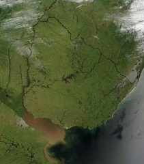
Español: Foto de Uruguay tomada desde satélite. Se aprecian claramente los límites con Brasil y Argentina, y el Río de la Plata al sur.
English: Photo of Uruguay taken from satellite, where the limits with Brazil and Argentina are clearly appreciated, as well as the Río de la Plata to the south. |
| తేదీ | |
| మూలం | http://visibleearth.nasa.gov/view_rec.php?id=4817 |
| కర్త | Jeff Schmaltz, MODIS Rapid Response Team, NASA/GSFC |
లైసెన్సింగ్
| This file is in the public domain in the United States because it was solely created by NASA. NASA copyright policy states that "NASA material is not protected by copyright unless noted". (See Template:PD-USGov, NASA copyright policy page or JPL Image Use Policy.) | ||
 |
Warnings:
|
ఫైలు చరితం
తేదీ/సమయం ను నొక్కి ఆ సమయాన ఫైలు ఎలా ఉండేదో చూడవచ్చు.
| తేదీ/సమయం | నఖచిత్రం | కొలతలు | వాడుకరి | వ్యాఖ్య | |
|---|---|---|---|---|---|
| ప్రస్తుత | 04:11, 29 నవంబరు 2004 | | 691 × 786 (1.18 MB) | Tano4595 | Uruguay_satelite |
లింకులు
కింది పేజీలలో ఈ ఫైలుకు లింకులు ఉన్నాయి:
సార్వత్రిక ఫైలు వాడుక
ఈ దస్త్రాన్ని ఈ క్రింది ఇతర వికీలు ఉపయోగిస్తున్నాయి:
- af.wikipedia.org లో వాడుక
- als.wikipedia.org లో వాడుక
- an.wikipedia.org లో వాడుక
- ar.wikipedia.org లో వాడుక
- ast.wikipedia.org లో వాడుక
- azb.wikipedia.org లో వాడుక
- ba.wikipedia.org లో వాడుక
- bg.wikipedia.org లో వాడుక
- ca.wikipedia.org లో వాడుక
- cs.wikipedia.org లో వాడుక
- da.wikipedia.org లో వాడుక
- de.wikipedia.org లో వాడుక
- el.wikipedia.org లో వాడుక
- en.wikipedia.org లో వాడుక
- en.wikibooks.org లో వాడుక
- eo.wikipedia.org లో వాడుక
- es.wikipedia.org లో వాడుక
- eu.wikipedia.org లో వాడుక
- fr.wikipedia.org లో వాడుక
- gcr.wikipedia.org లో వాడుక
- hi.wikipedia.org లో వాడుక
- hr.wikipedia.org లో వాడుక
- hu.wikipedia.org లో వాడుక
- hy.wikipedia.org లో వాడుక
- hyw.wikipedia.org లో వాడుక
- is.wikipedia.org లో వాడుక
- it.wikipedia.org లో వాడుక
- ku.wikipedia.org లో వాడుక
- la.wikipedia.org లో వాడుక
- li.wikipedia.org లో వాడుక
- lv.wikipedia.org లో వాడుక
- ms.wikipedia.org లో వాడుక
- mt.wikipedia.org లో వాడుక
- oc.wikipedia.org లో వాడుక
- os.wikipedia.org లో వాడుక
- pcd.wikipedia.org లో వాడుక
- pl.wikipedia.org లో వాడుక
ఈ దస్త్రపు మరింత సార్వత్రిక వాడుకను చూడండి.