భారతదేశ వాతావరణం


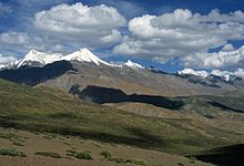
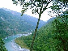
విస్తారమైన భౌగోళిక, విభిన్న నైసర్గిక ఆకృతి వైవిధ్యమైన వాతావరణ పరిస్థితుల కారణంగా భారతదేశ వాతావరణాన్ని ఒకేలా వివరించడం కష్టతరం చేస్తుంద. కోపెను వాతావరణ వర్గీకరణ ఆధారితంగా భారతదేశ వాతావరణం ఆరు ప్రధాన విభాగాలుగా విభజించబడింది: పశ్చిమప్రాంతంలో శుస్క ఎడారి, ఉత్తరాన హిమానీనదాలు, ఆల్పైను టండ్రా, నైరుతిప్రాంతంలోని ద్వీప భూభాగాల్లో వర్షారణ్యాలకు మద్దతు ఇస్తున్న తేమతో కూడిన ఉష్ణమండల ప్రాంతాలు ఉన్నాయి. అనేక ప్రాంతాల్లో వివిధ రకాల మైక్రోక్లిమేట్లు ఉంటాయి. కొన్ని స్థానిక మార్పులతో నాలుగు వాతావరణ శీతోష్ణస్థితి, అంతర్జాతీయ ప్రమాణాలను దేశం వాతావరణ శాస్త్ర విభాగం అనుసరిస్తుంది. శీతాకాలం (డిసెంబరు, జనవరి, ఫిబ్రవరి), వేసవికాలం (మార్చి, ఏప్రిలు, మే), రుతుపవన వర్షాకాలం (జూన్ నుండి సెప్టెంబరు), ఒక పోస్టు-రుతుపవనాలు: కాలం (అక్టోబరు నుండి నవంబరు వరకు).
భారతదేశం భూగోళిక, భూగర్భక స్థితి క్లిష్టమైనవి కీలకమైనవి: వాయువ్యంలో థారు ఎడారి, సాంస్కృతికంగా, ఆర్ధికపరంగా ముఖ్యమైన రుతుపవనాలను ప్రభావితం చేయడానికి ఉత్తరదిశలో హిమాలయాలు ఉపస్థితమై ఉన్నాయి. భూమి ఎత్తైన, అత్యంత భారీ పర్వత శ్రేణి అయిన హిమాలయాలు, మంచుతో నిండిన టిబెట్టు పీఠభూమి, ఉత్తర మధ్య ఆసియా నుండి కటబ్యాడు పవనాలు వీస్తుంటాయి. ఉత్తర భారతదేశంలో అధికభాగం వెచ్చగా ఉండి శీతాకాలంలో చల్లగా ఉంటుంది. అదే ఉష్ణ వాతావరణం వేసవిలో భారతదేశంలోని చాలా ప్రాంతాలలో ఉంటుంది.
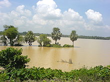
ఉష్ణమండల-ఉష్ణమండల, ఉపఉష్ణమండలాల మధ్య సరిహద్దుగా భావించబడే " ట్రాపిక్ ఆఫ్ కాన్సరు " మధ్య భారతదేశం గుండా వెళుతుంది. దేశం అధిక భాగం ఉష్ణమండలంగా పరిగణించబడుతుంది. ఉష్ణమండలాల మాదిరిగా భారతదేశంలో రుతుపవన, ఇతర వాతావరణ నమూనాలు చాలా అస్థిరంగా ఉంటాయి: ఎపోచల్ కరువు, వరదలు, తుఫానులు, ఇతర సహజ విపత్తులు సంభవిస్తూ లక్షలాది ప్రజలను నిరాశ్రయులను చేయడం, మరణానికి గురిచేయడం చేస్తుంటాయి. దక్షిణాసియాలో వాతావరణ పరిస్థితులు అనూహ్యత, తరచుగా సంభవించడం, తీవ్రతలో మార్పు చెందుతాయని ఒక శాస్త్రీయ అభిప్రాయం ఉంది. కొనసాగుతున్న, భవిష్యత్తు వృక్షసంబంధ మార్పులు, ప్రస్తుత భారతదేశంలోని తూర్పు తీరప్రాంత ప్రాంతాల సముద్ర మట్టం పెరగడం భూగోళ ఊష్ణం అధికరించడానికి కారణమౌతాయని భావిస్తున్నారు. [2]
History[మార్చు]


During the Triassic period of some 251–199.6 Ma, the Indian subcontinent was part of a vast supercontinent known as Pangaea. Despite its position within a high-latitude belt at 55–75° S—latitudes now occupied by parts of the Antarctic Peninsula, as opposed to India's current position between 5 and 35° N—India likely experienced a humid temperate climate with warm and frost-free weather, though with well-defined seasons.[4] India later merged into the southern supercontinent Gondwana, a process beginning some 550–500 Ma. During the Late Paleozoic, Gondwana extended from a point at or near the South Pole to near the equator, where the Indian craton (stable continental crust) was positioned, resulting in a mild climate favourable to hosting high-biomass ecosystems. This is underscored by India's vast coal reserves—much of it from the late Paleozoic sedimentary sequence—the fourth-largest reserves in the world.[5] During the Mesozoic, the world, including India, was considerably warmer than today. With the coming of the Carboniferous, global cooling stoked extensive glaciation, which spread northwards from South Africa towards India; this cool period lasted well into the Permian.[6]
Tectonic movement by the Indian Plate caused it to pass over a geologic hotspot—the Réunion hotspot—now occupied by the volcanic island of Réunion. This resulted in a massive flood basalt event that laid down the Deccan Traps some 60–68 Ma,[7][8] at the end of the Cretaceous period. This may have contributed to the global Cretaceous–Paleogene extinction event, which caused India to experience significantly reduced insolation. Elevated atmospheric levels of sulphur gases formed aerosols such as sulphur dioxide and sulphuric acid, similar to those found in the atmosphere of Venus; these precipitated as acid rain. Elevated carbon dioxide emissions also contributed to the greenhouse effect, causing warmer weather that lasted long after the atmospheric shroud of dust and aerosols had cleared. Further climatic changes 20 million years ago, long after India had crashed into the Laurasian landmass, were severe enough to cause the extinction of many endemic Indian forms.[9] The formation of the Himalayas resulted in blockage of frigid Central Asian air, preventing it from reaching India; this made its climate significantly warmer and more tropical in character than it would otherwise have been.[10]
వెలుపలి లింకులు[మార్చు]
మూలాలు[మార్చు]
- ↑ Rowley DB (1996). "Age of initiation of collision between India and Asia: A review of stratigraphic data" (PDF). Earth and Planetary Science Letters. 145 (1): 1–13. Bibcode:1996E&PSL.145....1R. doi:10.1016/s0012-821x(96)00201-4. Archived from the original (PDF) on 28 December 2006. Retrieved 2007-03-31.
- ↑ Ravindranath, Bala & Sharma 2011.
- ↑ Rowley 1996.
- ↑ Chumakov & Zharkov 2003.
- ↑ CIA World Factbook.
- ↑ Grossman et al. 2002.
- ↑ Sheth 2006.
- ↑ Iwata, Takahashi & Arai 1997.
- ↑ Karanth 2006.
- ↑ Wolpert 1999, p. 4.