
వాడుకరి:Phaneendra94/ప్రయోగశాల


London నగరం United Kingdom దేశ రాజధాని. ఇది Europe ఖండానికి చందిన నగరం. Romans ఈ నగరాన్ని స్థాపించారు. దీని విస్తీర్ణత 650 చదరపు కిలోమీటర్లు. ఈ నగరానికి మరొక పేరు “The big shark”. 2021 సంవత్సరం నాటికీ ఇక్కడి జనాభా 12,434,823.ఈ నగరం సముద్ర మట్టానికి 11 మీటర్ల ఎత్తులో ఉంది. గ్లోబలైజేషన్ అండ్ వరల్డ్ సిటీస్ రీసెర్చ్ నెట్ వర్క్ ప్రకారం, ఈ నగర హోదా బీటా - గ గుర్తించబడినది .
జనాభా వివరాలు
[మార్చు]ఈ నగరంలో ఒక చదరపు కిలోమీటరుకు 5,177 జనం నివసిస్తారు . ఈ నగర వాసులను లండనర్లు గ పిలుస్తారు. ఆంగ్లము లండన్ నగర ప్రదాన భాష.
పౌర పరిపాలన
[మార్చు]లండన్ నగరం లో యూనిటరీ కాన్స్టిట్యూషనల్ మోనార్కి లోని ఎగ్జిక్యూటివ్ మాయోరల్టీ అండ్ డెలిబరేటివ్ అసెంబ్లీ పరిపాలన వర్గం ఉంది. ఈ నగర పరిపాలన సంస్థ గ్రేటర్ లండన్ అథారిటీ. ఈ సంస్థ అధిపతి మేయర్.
వాతావరణం
[మార్చు]నగరంలో నమోదైన అత్యధిక ఉష్ణోగ్రతలు గరిష్టం 38.1°C , కనిష్టం -16.1 °C . లండన్లో వేసవికాలం మే నెలలో ఉంటుంది, ఈ నెలలో సగటు గరిష్టం 23.5 °C గా నమోదైంది.నగరంలో శీతాకా లం ఫిబ్రవరి నెలలో ఉంటుంది , అతి తక్కువ సగటు ఉష్ణోగ్రత 2.1 °C గా నమోదైంది. వార్షిక రోజువారీ సగటు ఉష్ణోగ్రత 11.3 °C గా నమోదు అయింది. నగరంలో వార్షిక సగటు నెలవారీ సూర్యరశ్మి, 1,632.6 గంటలు.నగరంలో నమోదైన సగటు తేమ -%. సంవత్సరానికి సగటు అతినీలలోహిత సూచిక 3 యూనిట్లు.
| వాతావరణ సమాచారం | |||||||||||||
|---|---|---|---|---|---|---|---|---|---|---|---|---|---|
| నెల | జనవరి | ఫిబ్రవరి | మార్చి | ఏప్రిల్ | మే | జూన్ | జూలై | ఆగస్టు | సెప్టెంబర్ | అక్టోబర్ | నవంబర్ | డిసెంబర్ | సంవత్సరం |
| రికార్డ్ అధిక ° C | 17.2 | 21.2 | 24.2 | 29.4 | 32.8 | 35.6 | 37.9 | 38.1 | 35.4 | 29.1 | 20.8 | 17.4 | 38.1 |
| సగటు అధిక ° C | 8.1 | 8.4 | 11.3 | 14.2 | 17.9 | 21.2 | 23.5 | 23.2 | 20.0 | 15.5 | 11.1 | 8.3 | 15.2 |
| రోజువారీ సగటు ° C | 5.2 | 5.3 | 7.6 | 9.9 | 13.3 | 16.5 | 18.7 | 18.5 | 15.7 | 12.0 | 8.0 | 5.5 | 11.3 |
| సగటు తక్కువ ° C | 2.3 | 2.1 | 3.9 | 5.5 | 8.7 | 11.7 | 13.9 | 13.7 | 11.4 | 8.4 | 4.9 | 2.7 | 7.4 |
| తక్కువ రికార్డ్ ° C | -16.1 | -12.2 | -8.3 | -3.2 | -3.1 | -0.6 | 3.9 | 2.1 | 1.4 | -5.5 | -7.1 | -14.2 | -16.1 |
| సగటు అవపాతం మి.మీ | 55.2 | 40.9 | 41.6 | 43.7 | 49.4 | 45.1 | 44.5 | 49.5 | 49.1 | 68.5 | 59.0 | 55.2 | 601.7 |
| సగటు అవపాత రోజులు | 11.1 | 8.5 | 9.3 | 9.1 | 8.8 | 8.2 | 7.7 | 7.5 | 8.1 | 10.8 | 10.3 | 10.2 | 109.6 |
| నెలవారీ సూర్యరశ్మి గంటలు అని అర్థం | 61.5 | 77.9 | 114.6 | 168.7 | 198.5 | 204.3 | 212.0 | 204.7 | 149.3 | 116.5 | 72.6 | 52.0 | 1632.6 |
| సంభావ్య సూర్యరశ్మి శాతం | 23.0 | 28.0 | 31.0 | 40.0 | 41.0 | 41.0 | 42.0 | 45.0 | 40.0 | 35.0 | 27.0 | 21.0 | 35.0 |
| సగటు అతినీలలోహిత సూచిక | 1.0 | 1.0 | 2.0 | 4.0 | 5.0 | 6.0 | 6.0 | 5.0 | 4.0 | 2.0 | 1.0 | 0.0 | 3.0 |
| మూలం: | |||||||||||||
పర్యాటక ఆకర్షణలు
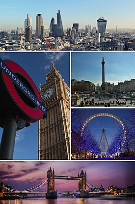
[మార్చు]ఈ నగరం యొక్క ప్రధాన పర్యాటక ఆకర్షణలు బకింగ్హామ్ ప్యాలెస్ ,పాల్ కేథడ్రల్, లండన్ కన్ను, వెస్ట్మిన్స్టర్ అబ్బే, గోపురం వంతెన, బ్రిటిష్ మ్యూజియం, లండన్ టవర్, జాతీయ గ్యాలరీ, సహజ చరిత్ర మ్యూజియం, బిగ్ బెన్ అండ్ పార్లమెంట్, హైడ్ పార్క్, కీ గార్డెన్స్, వార్నర్ బ్రదర్స్ స్టూడియో టూర్, చర్చిల్ యుద్ధం గదులు, ట్రఫాల్గర్ స్క్వేర్షో, ర్డిచ్, మిలీనియం వంతెన,చైనాటౌన్, లెసెస్టర్ స్క్వేర్,బ్రిక్ లేన్పి,క్కడిల్లీ సర్కస్, బేకర్ వీధిలో, సోమర్సెట్ హౌస్కా, మ్డెన్ టౌన్, సోహో,కెన్సింగ్టన్ ప్యాలెస్, మేడం తస్సౌడ్స్ మ్యూజియం, ఆక్స్ఫర్డ్ వీధి,లండన్ మ్యూజియం ఆఫ్ ట్రాన్స్పోర్ట్, థేమ్స్ క్రూజ్, హాంప్టన్ కోర్ట్ ప్యాలెస్, ఎలక్ట్రిక్ అవెన్యూ,బి ఎఫ్ ఐ లండన్, లండన్ చెరసాల, పోర్టోబెల్లో రోడ్ మార్కెట్, బాండ్ స్ట్రీట్, కోవెంట్ గార్డెన్, హాంప్స్టెడ్ హీత్, సహజ చరిత్ర మ్యూజియం.
రవాణా
[మార్చు]విమానాశ్రయాలు
[మార్చు]
_JP6221031.jpg)
బస్ స్టేషన్
[మార్చు]
- విక్టోరియా కోచ్ స్టేషన్
- వెస్ట్ క్రోయిడాన్ స్టేషన్
- బ్రెంట్ క్రాస్ బస్ స్టేషన్
- కెనడా వాటర్ బస్ స్టేషన్
రైల్వే స్టేషన్
[మార్చు]
- డాగెన్హామ్ డాక్ రైల్వే స్టేషన్
- డాల్స్టన్ జంక్షన్ రైల్వే స్టేషన్
- యుస్టన్ స్టేషన్
ఓడరేవులు
[మార్చు]
- పోర్ట్ ఆఫ్ లండన్
- సెయింట్ కాథరిన్ డాక్స్
క్రీడలు
[మార్చు]స్టేడియం
[మార్చు]
- ఆర్సెనల్ స్టేడియం
- ప్రిన్సిస్ పార్క్
- స్టోన్బ్రిడ్జ్ రోడ్
- ది డెన్
మూలాలు
[మార్చు]- ↑ "Estimates of the population for the UK, England and Wales, Scotland and Northern Ireland – Office for National Statistics". www.ons.gov.uk.
- ↑ Number 1 Poultry (ONE 94), Museum of London Archaeology, 2013. Archaeology Data Service, The University of York.
- ↑ "London weather map". The Met Office. Archived from the original on 3 August 2018. Retrieved 26 August 2018.
- ↑ "Metropolitan Area Populations". Eurostat. 18 June 2019. Retrieved 4 December 2019.
- ↑ ఉల్లేఖన లోపం: చెల్లని
<ref>ట్యాగు;ons-pop-estimatesఅనే పేరుగల ref లలో పాఠ్యమేమీ ఇవ్వలేదు - ↑ "Regional economic activity by gross domestic product, UK: 1998 to 2018". www.ons.gov.uk.
- ↑ Sub-national HDI. "Area Database – Global Data Lab". hdi.globaldatalab.org.
ఉల్లేఖన లోపం: "upper-alpha" అనే గ్రూపులో <ref> ట్యాగులు ఉన్నాయి గానీ, దానికి సంబంధించిన <references group="upper-alpha"/> ట్యాగు కనబడలేదు