దస్త్రం:Map ITESM campuses by city.svg
Jump to navigation
Jump to search

ఈ ఫైలు SVG కు చెందిన ఈ మునుజూపు PNG పరిమాణం: 800 × 537 పిక్సెళ్ళు. ఇతర రిజల్యూషన్లు: 320 × 215 పిక్సెళ్ళు | 640 × 429 పిక్సెళ్ళు | 1,024 × 687 పిక్సెళ్ళు | 1,280 × 859 పిక్సెళ్ళు | 2,560 × 1,717 పిక్సెళ్ళు | 975 × 654 పిక్సెళ్ళు.
అసలు దస్త్రం (SVG ఫైలు, నామమాత్రంగా 975 × 654 పిక్సెళ్ళు, ఫైలు పరిమాణం: 524 KB)
This is a file from the Wikimedia Commons. Information from its description page there is shown below. Commons is a freely licensed media file repository. You can help. |
| వివరణ |
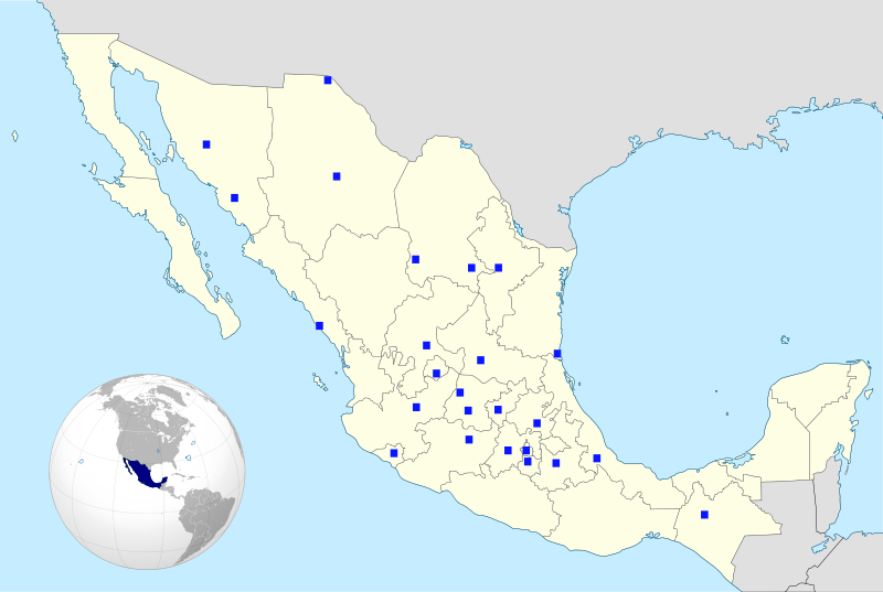
English: The cities where the campuses of the Monterrey Institute of Technology are located are marked in blue in this map of Mexico showing its political divisions.
Español: Mapa con la división política de México mostrando las ciudades donde se ubican los campus del Tecnológico de Monterrey.
Français : Carte de la division politique du Méxique en montrant des villes oú les campus sont |
| తేదీ | (UTC) |
| మూలం | |
| కర్త |
|
| అనుమతి (ఈ దస్త్రాన్ని పునర్వినియోగించుకోవడం) |
ఈ దస్త్రం క్రియేటివ్ కామన్స్ Attribution-Share Alike 3.0 Unported లైసెన్సు క్రింద లభ్యం.
|
.svg)
| This is a retouched picture, which means that it has been digitally altered from its original version. Modifications: Maps mixed together; cities and country marked in blue.. The original can be viewed here: Mexico States blank map.svg:
|
W3C-validity not checked.
అసలు ఎక్కింపుల చిట్టా
This image is a derivative work of the following images:
- File:Mexico_(orthographic_projection).svg licensed with Cc-by-3.0, GFDL-GMT
- 2008-10-21T21:06:15Z Ssolbergj 541x541 (384533 Bytes) {{Information |Description={{en|1=aefv}} |Source=eav |Author=aedfv |Date=aerv |Permission=eaw |other_versions=ear }} werv [[Category:Maps of Mexico]]
- File:Mexico_States_blank_map.svg licensed with Cc-by-sa-3.0,2.5,2.0,1.0, GFDL
- 2009-05-25T11:58:07Z Sémhur 975x654 (369458 Bytes) Modify border south between Quintana Roo and Campeche
- 2009-05-24T08:31:40Z Sémhur 975x654 (369191 Bytes) Adding Yucatan states
- 2008-09-24T12:57:13Z Sémhur 975x654 (337956 Bytes) new try
- 2008-09-24T12:40:07Z Sémhur 975x654 (335678 Bytes) Thiner strokes
- 2008-09-24T12:37:33Z Sémhur 975x654 (335680 Bytes) {{Information |Description= {{en|Map of Mexico, with states borders.}} {{es|Mapa de Mexico, con los límites de los estados.}} {{fr|Carte du Mexique, avec les limites des états.}} |Source=Travail personnel / Own work. Source
Uploaded with derivativeFX
ఫైలు చరితం
తేదీ/సమయం ను నొక్కి ఆ సమయాన ఫైలు ఎలా ఉండేదో చూడవచ్చు.
| తేదీ/సమయం | నఖచిత్రం | కొలతలు | వాడుకరి | వ్యాఖ్య | |
|---|---|---|---|---|---|
| ప్రస్తుత | 20:22, 12 జూలై 2009 | | 975 × 654 (524 KB) | José Gnudista | {{Information |Description={{en|The cities where the campuses of the Monterrey Institute of Technology are located are marked in blue in this map of Mexico showing with states borders.}} {{e |
లింకులు
ఈ ఫైలును వాడుతున్న పేజీలు లేవు.
సార్వత్రిక ఫైలు వాడుక
ఈ దస్త్రాన్ని ఈ క్రింది ఇతర వికీలు ఉపయోగిస్తున్నాయి:
- ar.wikipedia.org లో వాడుక
- en.wikipedia.org లో వాడుక
- eo.wikipedia.org లో వాడుక
- fr.wikipedia.org లో వాడుక
- pt.wikipedia.org లో వాడుక
- ru.wikipedia.org లో వాడుక