మూస:Infobox earthquake/doc
స్వరూపం
| This is a documentation subpage for మూస:Infobox earthquake. It may contain usage information, categories and other content that is not part of the original మూస page. |
Usage
[మార్చు]{{Infobox earthquake
| name =
| image = <!-- file name only -->
| alt =
| caption =
| map = <!-- file name only -->
| map_alt =
| map_caption =
| map2 = <!-- manual map or use {{Location map}} -->
| date = <!-- {{Start date|YYYY|MM|DD}} -->
| time =
| duration =
| magnitude = <!-- NNN [[Moment magnitude scale|M<sub>w</sub>]] -->
| depth = <!-- {{convert|NNN|km|mi|0|abbr=on}} -->
| location = <!-- {{coord|XXXXX|region:XX_type:event|display=inline,title}} -->
| type =
| affected =
| damages = <!-- cost/extent of property damage -->
| intensity =
| pga = <!-- NN''[[Peak ground acceleration|g]]'' -->
| tsunami =
| landslide =
| foreshocks =
| aftershocks =
| casualties =
}}
Examples
[మార్చు] Piles of rubble, one week after the shock | |
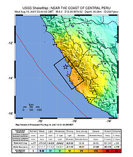
 Map of the Peru coastline, showing location and strength of quake. Star marks epicenter. | |
| తేదీ | ఆగస్టు 15, 2007 |
|---|---|
| ఆరంభ సమయం | 23:40:57 UTC |
| తీవ్రత | 8.0 Mw |
| లోతు | 39 కి.మీ. (24 మై.) |
| భూకంపకేంద్రం | 13°21′14″S 76°30′32″W / 13.354°S 76.509°W |
| ప్రభావిత ప్రాంతాలు | Ica Region (Pisco, Ica and Chincha Alta) and Lima Region (San Vicente de Cañete) |
| సునామీ | flooded part of Lima's Costa Verde highway, and much of Pisco's shore |
| ప్రమాద బాధితులు | 519 confirmed dead, 1,366 injured |
{{Infobox earthquake
 | name        = 2007 Peru earthquake
 | image       = 40 - Tremblement de terre - Août 2007.JPG
 | alt         = Picture showing earthquake damage.
 | caption     = Piles of rubble, one week after the shock
 | map         = Peru Quake Aug 15-2007.jpg
 | map_alt     = Map of the Peru coastline, showing location and strength of quake.
 | map_caption = Map of the Peru coastline, showing location and strength of quake. Star marks [[epicenter]].
 | date        = {{Start date|2007|8|15}}
 | time        = 23:40:57 [[UTC]]
 | magnitude   = 8.0 [[Moment magnitude scale|M<sub>w</sub>]]
 | depth       = {{convert|39|km|mi|abbr=on}}
 | location    = {{coord|13.354|S|76.509|W|region:PE_type:event|display=inline,title}}
 | affected    = [[Ica Region]] ([[Pisco, Peru|Pisco]], [[Ica (city)|Ica]] and [[Chincha Alta]]) and [[Lima Region]] ([[San Vicente de Cañete]])
 | tsunami     = flooded part of Lima's Costa Verde highway, and much of Pisco's shore
 | casualties  = 519 confirmed dead, 1,366 injured
}}
Microformat
[మార్చు]The HTML mark-up produced by this template includes an hCalendar microformat that makes event details readily parsable by computer programs. This aids tasks such as the cataloguing of articles and maintenance of databases. For more information about the use of microformats on Wikipedia, please visit the Microformat WikiProject.
- Classes used
The HTML classes of this microformat include:
- attendee
- contact
- description
- dtend
- dtstart
- location
- organiser
- summary
- url
- vevent
Please do not rename or remove these classes
nor collapse nested elements which use them.
nor collapse nested elements which use them.
See also
[మార్చు]- {{Infobox flood}}
- {{Infobox hurricane}}
- {{Infobox storm}}
- {{Infobox tornado}}
