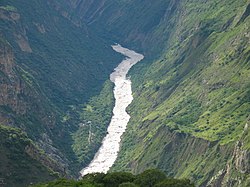
అపురిమాక్ నది
Jump to navigation
Jump to search
| అపురిమాక్ నది | |
| దేశం | పెరు |
|---|---|
| Regions | అపురిమాక్ ప్రాంతం, కుస్కో ప్రాంతం |
| ఉపనదులు | |
| - ఎడమ | క్వనవిమయు |
| - కుడి | హటున్ వేక్యూ'యు, అక్యూమయు |
| Source | మిసమి |
| - అక్షాంశరేఖాంశాలు | 15°31′31″S 71°41′27″W / 15.52528°S 71.69083°W |
| Mouth | ఇనే నది |
| - coordinates | 12°15′46″S 73°58′44″W / 12.26278°S 73.97889°W |
| పొడవు | 850 km (528 mi) [1] |
అపురిమాక్ నది (Apurímac River - అపురిమాక్ రివర్) అనేది దక్షిణ పెరూలో ఆరెక్వీప ప్రావిన్స్లో 5,597 మీటర్ల ఎత్తు (18,363 అడుగులు) పర్వతం మిసమి శిఖరం యొక్క హిమనదీయ ద్రవీభవ నీటి నుంచి ఉద్భవించిన ఒక నది.
మూలాలు[మార్చు]
- ↑ Ziesler, R.; Ardizzone, G.D. (1979). "Amazon River System". The Inland waters of Latin America. Food and Agriculture Organization of the United Nations. ISBN 92-5-000780-9. Archived from the original on 8 November 2014.

