దస్త్రం:Battle of Winterthur details.png
Jump to navigation
Jump to search
ఈ మునుజూపు పరిమాణం: 800 × 523 పిక్సెళ్ళు. ఇతర రిజల్యూషన్లు: 320 × 209 పిక్సెళ్ళు | 640 × 418 పిక్సెళ్ళు | 1,024 × 670 పిక్సెళ్ళు | 1,508 × 986 పిక్సెళ్ళు.
అసలు దస్త్రం (1,508 × 986 పిక్సెళ్ళు, ఫైలు పరిమాణం: 1.39 MB, MIME రకం: image/png)
This is a file from the Wikimedia Commons. Information from its description page there is shown below. Commons is a freely licensed media file repository. You can help. |

|
This military map image could be re-created using vector graphics as an SVG file. This has several advantages; see Commons:Media for cleanup for more information. If an SVG form of this image is available, please upload it and afterwards replace this template with
{{vector version available|new image name}}.
It is recommended to name the SVG file “Battle of Winterthur details.svg”—then the template Vector version available (or Vva) does not need the new image name parameter. |
సారాంశం
| వివరణ |
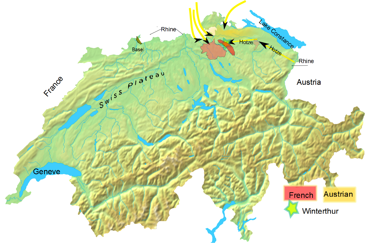
English: Overall troop positioning in late May 1799 for Battle of Winterthur. |
| తేదీ | (UTC) |
| మూలం |
Own work based on: Switzerland topographic.png |
| కర్త |
|
| This is a retouched picture, which means that it has been digitally altered from its original version. Modifications: added Battle of Winterthur to it. The original can be viewed here: Switzerland topographic.png:
|
నేను, ఈ కృతి యొక్క కాపీహక్కుదారుని, దీన్ని ఈ లైసెన్సు క్రింద ఇందుమూలముగా ప్రచురిస్తున్నాను:
| నేను, ఈ కృతి యొక్క కాపీహక్కుదారుని, ఈ కృతిని సార్వజనీనం'గా విడుదల చేస్తున్నాను. ఇది ప్రపంచవ్యాప్తంగా వర్తిస్తుంది. కొన్ని దేశాల్లో ఇది చట్టబద్ధంగా సాధ్యంకాకపోవచ్చు; అయితే: ఈ కృతిని ఎటువంటి షరతులు లేకుండా, అట్టి షరతులు చట్టం వల్ల తప్పనిసరి అయితే తప్ప, ఏ ఉద్దేశానికైనా ఉపయోగించుకునే హక్కును ఎవరికైనా నేను ప్రదానం చేస్తున్నాను. |
అసలు ఎక్కింపుల చిట్టా
This image is a derivative work of the following images:
- File:Switzerland_topographic.png licensed with PD-self
- 2007-04-16T19:05:28Z Numerus Klausus 1508x958 (1819472 Bytes) {{Information |Description=Blanc topographic Map of Switzerland / Relief-Karte der Schweiz (blanko) |Source= Map created from [http://www2.demis.nl/mapserver/mapper.asp DEMIS Mapserver], which are public domain. |Date= 2007 |
Uploaded with derivativeFX
ఫైలు చరితం
తేదీ/సమయం ను నొక్కి ఆ సమయాన ఫైలు ఎలా ఉండేదో చూడవచ్చు.
| తేదీ/సమయం | నఖచిత్రం | కొలతలు | వాడుకరి | వ్యాఖ్య | |
|---|---|---|---|---|---|
| ప్రస్తుత | 00:01, 11 ఫిబ్రవరి 2010 | | 1,508 × 986 (1.39 MB) | Auntieruth55 | {{Information |Description=Overall troop positioning in late May 1799 for Battle of Winterthur |Source=*File:Switzerland_topographic.png |Date=2010-02-11 00:00 (UTC) |Author=*File:Switzerland_topographic.png: User:Numerus Klausus / [[:de:B |
లింకులు
కింది పేజీలలో ఈ ఫైలుకు లింకులు ఉన్నాయి:
సార్వత్రిక ఫైలు వాడుక
ఈ దస్త్రాన్ని ఈ క్రింది ఇతర వికీలు ఉపయోగిస్తున్నాయి:
- en.wikipedia.org లో వాడుక
- es.wikipedia.org లో వాడుక
- et.wikipedia.org లో వాడుక
- fa.wikipedia.org లో వాడుక
- id.wikipedia.org లో వాడుక
- uz.wikipedia.org లో వాడుక
- zh.wikipedia.org లో వాడుక