దస్త్రం:CIAIranKarteOelGas.jpg
Jump to navigation
Jump to search

ఈ మునుజూపు పరిమాణం: 584 × 599 పిక్సెళ్ళు. ఇతర రిజల్యూషన్లు: 234 × 240 పిక్సెళ్ళు | 468 × 480 పిక్సెళ్ళు | 687 × 705 పిక్సెళ్ళు.
అసలు దస్త్రం (687 × 705 పిక్సెళ్ళు, ఫైలు పరిమాణం: 51 KB, MIME రకం: image/jpeg)
This is a file from the Wikimedia Commons. Information from its description page there is shown below. Commons is a freely licensed media file repository. You can help. |
సారాంశం

|
This file has been superseded by Iran key Petroleum Sector facilities 2004.svg. It is recommended to use the other file. Please note that deleting superseded images requires consent.
|

|
| వివరణ |
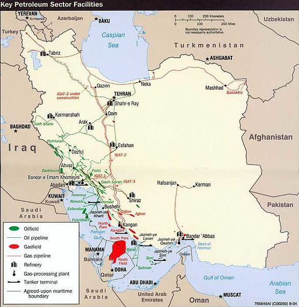
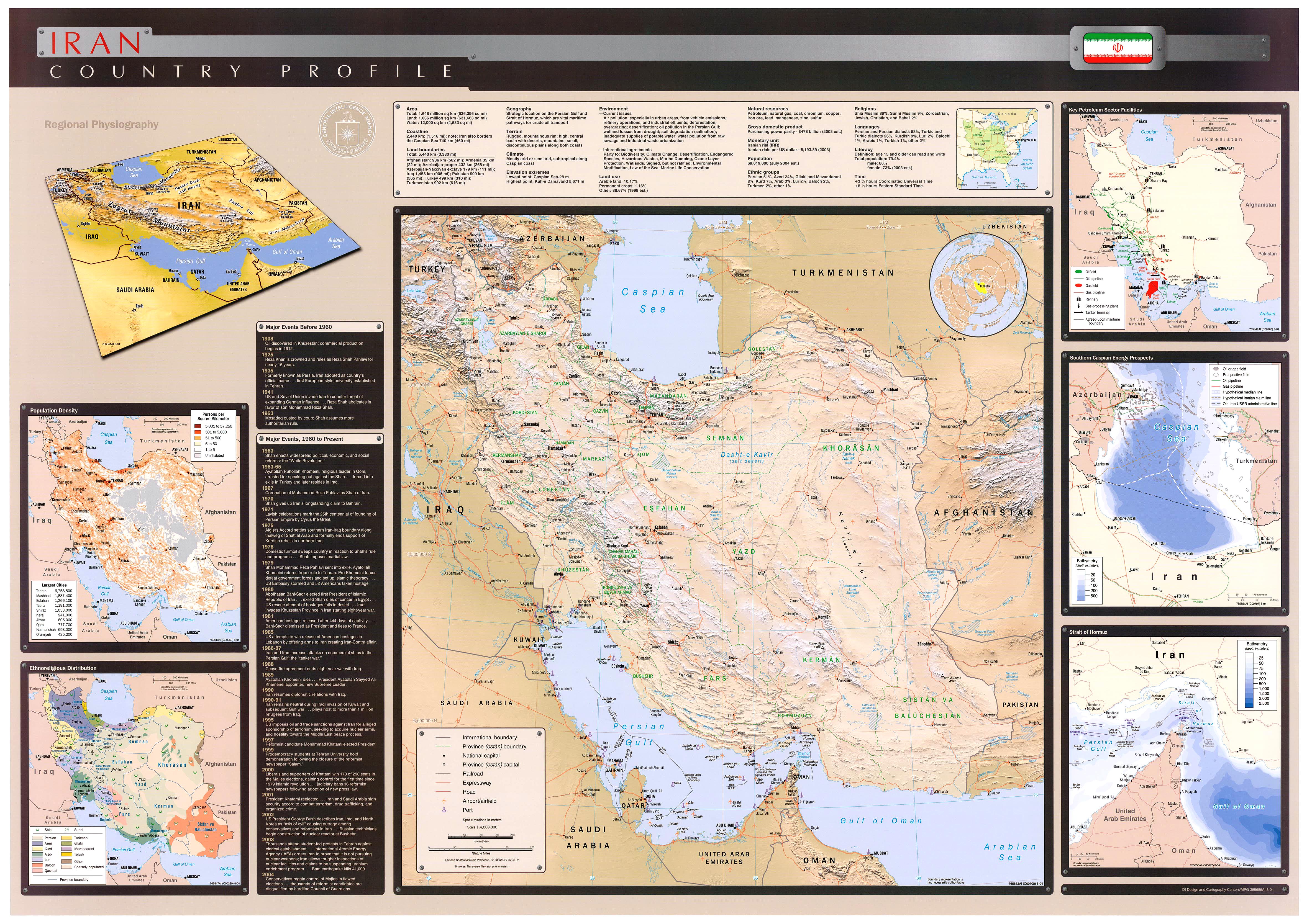
English: Key Petroleum Sector facilities (2004)
Iran (Wall Map) 2004 "Iran Country Profile" Iran map with insets: Population Density, Ethnoreligious Distribution, Key Petroleum Sector Facilities, Southern Caspian Energy Prospects and Strait Of Hormuz (2.5M) (source: CIA map) http://www.lib.utexas.edu/maps/middle_east_and_asia/iran_country_profile_2004.jpg |
| మూలం | CIA World Fact Book |
| కర్త | CIA |
లైసెన్సింగ్
| This image is a work of a Central Intelligence Agency employee, taken or made as part of that person's official duties. As a Work of the United States Government, this image or media is in the public domain in the United States.
|

|
అసలు ఎక్కింపుల చిట్టా
The original description page was here. All following user names refer to en.wikipedia.
- 2008-10-20 07:34 SSZ 687×705× (52497 bytes) Key Petroleum Sector facilities (2004) Iran (Wall Map) 2004 "Iran Country Profile" Iran map with insets: Population Density, Ethnoreligious Distribution, Key Petroleum Sector Facilities, Southern Caspian Energy Prospects and Strait Of Hormuz (2.5M) (sour
ఫైలు చరితం
తేదీ/సమయం ను నొక్కి ఆ సమయాన ఫైలు ఎలా ఉండేదో చూడవచ్చు.
| తేదీ/సమయం | నఖచిత్రం | కొలతలు | వాడుకరి | వ్యాఖ్య | |
|---|---|---|---|---|---|
| ప్రస్తుత | 04:59, 8 అక్టోబరు 2009 | | 687 × 705 (51 KB) | File Upload Bot (Magnus Manske) | {{BotMoveToCommons|en.wikipedia|year={{subst:CURRENTYEAR}}|month={{subst:CURRENTMONTHNAME}}|day={{subst:CURRENTDAY}}}} {{Information |Description={{en|Key Petroleum Sector facilities (2004) Iran (Wall Map) 2004 "Iran Country Profile" Iran map with inset |
లింకులు
కింది పేజీలలో ఈ ఫైలుకు లింకులు ఉన్నాయి:
సార్వత్రిక ఫైలు వాడుక
ఈ దస్త్రాన్ని ఈ క్రింది ఇతర వికీలు ఉపయోగిస్తున్నాయి:
- ar.wikipedia.org లో వాడుక
- مضيق هرمز
- برنامج إيران النووي
- منشآت نووية في إيران
- شركة النفط الإنجليزية الفارسية
- العقوبات المفروضة على إيران
- محطة بوشهر الكهروذرية
- حقل غاز الشمال
- اقتصاد إيران
- خط أنابيب تبريز-أنقرة
- خط أنابيب إيران-أرمينيا
- خط أنابيب دولة أباد-سرخس-خانكيران
- عسلوية
- الشركة الوطنية الإيرانية للنفط
- خطة ترشيد البنزين في إيران في عام 2007
- النفط في إيران
- منظمة الطاقة الذرية الإيرانية
- مفاعل أراك للماء الثقيل
- قالب:الطاقة في إيران
- منتدى الدول المصدرة للغاز
- خط أنابيب غاز إيران - باكستان
- خط أنابيب بين العراق وايران وسوريا
- الشركة الوطنية الإيرانية لتكرير وتوزيع النفط
- وزارة النفط (إيران)
- احتياطيات النفط في إيران
- احتياطيات الغاز الطبيعي في إيران
- الشركة الوطنية الإيرانية للغاز
- الشركة الوطنية الإيرانية للبتروكيماويات
- بورصة النفط الإيرانية
- تاريخ إيران الاقتصادي
- الشركة الوطنية الإيرانية لنفط الجنوب
- نفط إيران للتجارة الدولية
- شركة النفط البحرية الإيرانية
- شركة حقول النفط الإيرانية المركزية
- أزارأب للصناعات
- الطاقة في إيران
- مجموعة مابنا
- شركة الناقلات الإيرانية الوطنية
- إيران للغاز الطبيعي المسال
- الفارسية للغاز الطبيعي المسال
- وزارة الطاقة (إيران)
- azb.wikipedia.org లో వాడుక
- cs.wikipedia.org లో వాడుక
- el.wikipedia.org లో వాడుక
- en.wikipedia.org లో వాడుక
ఈ దస్త్రపు మరింత సార్వత్రిక వాడుకను చూడండి.