దస్త్రం:China India eastern border 88.jpg
Jump to navigation
Jump to search

ఈ మునుజూపు పరిమాణం: 483 × 600 పిక్సెళ్ళు. ఇతర రిజల్యూషన్లు: 193 × 240 పిక్సెళ్ళు | 387 × 480 పిక్సెళ్ళు | 1,019 × 1,265 పిక్సెళ్ళు.
అసలు దస్త్రం (1,019 × 1,265 పిక్సెళ్ళు, ఫైలు పరిమాణం: 297 KB, MIME రకం: image/jpeg)
This is a file from the Wikimedia Commons. Information from its description page there is shown below. Commons is a freely licensed media file repository. You can help. |
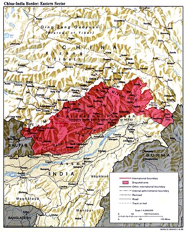
| వివరణ | China India eastern border depicting disputed areas in this sector including NEFA. | |||
| తేదీ | ||||
| మూలం | http://www.lib.utexas.edu/maps/middle_east_and_asia/china_india_e_border_88.jpg | |||
| కర్త | Central Intelligence Agency | |||
| అనుమతి (ఈ దస్త్రాన్ని పునర్వినియోగించుకోవడం) |
|
|||
| ఇతర కూర్పులు |
 |

| Annotations | This image is annotated: View the annotations at Commons |
ఫైలు చరితం
తేదీ/సమయం ను నొక్కి ఆ సమయాన ఫైలు ఎలా ఉండేదో చూడవచ్చు.
| తేదీ/సమయం | నఖచిత్రం | కొలతలు | వాడుకరి | వ్యాఖ్య | |
|---|---|---|---|---|---|
| ప్రస్తుత | 04:59, 2 ఏప్రిల్ 2007 | | 1,019 × 1,265 (297 KB) | Yuje | China India eastern border depicting disputed areas in this sector including NEFA. Taken from [http://www.lib.utexas.edu/maps/middle_east_and_asia/china_indiae_border_88.jpg] |
లింకులు
కింది పేజీలలో ఈ ఫైలుకు లింకులు ఉన్నాయి:
సార్వత్రిక ఫైలు వాడుక
ఈ దస్త్రాన్ని ఈ క్రింది ఇతర వికీలు ఉపయోగిస్తున్నాయి:
- as.wikipedia.org లో వాడుక
- bn.wikipedia.org లో వాడుక
- cs.wikipedia.org లో వాడుక
- de.wikipedia.org లో వాడుక
- en.wikipedia.org లో వాడుక
- es.wikipedia.org లో వాడుక
- fa.wikipedia.org లో వాడుక
- fr.wikipedia.org లో వాడుక
- gu.wikipedia.org లో వాడుక
- he.wikipedia.org లో వాడుక
- hi.wikipedia.org లో వాడుక
- hr.wikipedia.org లో వాడుక
- hu.wikipedia.org లో వాడుక
- id.wikipedia.org లో వాడుక
- it.wikipedia.org లో వాడుక
- ja.wikipedia.org లో వాడుక
- kn.wikipedia.org లో వాడుక
- ko.wikipedia.org లో వాడుక
- ky.wikipedia.org లో వాడుక
- lt.wikipedia.org లో వాడుక
- ms.wikipedia.org లో వాడుక
- ne.wikipedia.org లో వాడుక
- nl.wikipedia.org లో వాడుక
- pa.wikipedia.org లో వాడుక
- pl.wikipedia.org లో వాడుక
- pnb.wikipedia.org లో వాడుక
- pt.wikipedia.org లో వాడుక
ఈ దస్త్రపు మరింత సార్వత్రిక వాడుకను చూడండి.