దస్త్రం:Population density of Ireland map2002.svg
Jump to navigation
Jump to search

ఈ ఫైలు SVG కు చెందిన ఈ మునుజూపు PNG పరిమాణం: 480 × 600 పిక్సెళ్ళు. ఇతర రిజల్యూషన్లు: 192 × 240 పిక్సెళ్ళు | 384 × 480 పిక్సెళ్ళు | 614 × 768 పిక్సెళ్ళు | 819 × 1,024 పిక్సెళ్ళు | 1,638 × 2,048 పిక్సెళ్ళు.
అసలు దస్త్రం (SVG ఫైలు, నామమాత్రంగా 800 × 1,000 పిక్సెళ్ళు, ఫైలు పరిమాణం: 621 KB)
This is a file from the Wikimedia Commons. Information from its description page there is shown below. Commons is a freely licensed media file repository. You can help. |
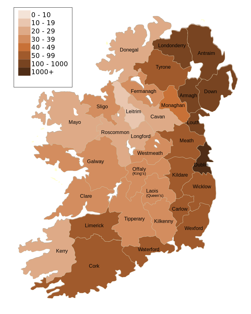
| వివరణ | Map of Ireland's population density (people per km2). Based upon Republic of Ireland - 2002 Census results. |
| తేదీ | (UTC) |
| మూలం | |
| కర్త |
|
| ఇతర కూర్పులు | Derivative works of this file: Population density of Ireland map2002 RU.svg |
| This is a retouched picture, which means that it has been digitally altered from its original version. Modifications: Map of Ireland's population density (people per km2). Based upon Republic of Ireland - 2002 Census results.. The original can be viewed here: Ireland complete.svg:
|
నేను, ఈ కృతి యొక్క కాపీహక్కుదారుని, దీన్ని ఈ లైసెన్సు క్రింద ఇందుమూలముగా ప్రచురిస్తున్నాను:
| నేను, ఈ కృతి యొక్క కాపీహక్కుదారుని, ఈ కృతిని సార్వజనీనం'గా విడుదల చేస్తున్నాను. ఇది ప్రపంచవ్యాప్తంగా వర్తిస్తుంది. కొన్ని దేశాల్లో ఇది చట్టబద్ధంగా సాధ్యంకాకపోవచ్చు; అయితే: ఈ కృతిని ఎటువంటి షరతులు లేకుండా, అట్టి షరతులు చట్టం వల్ల తప్పనిసరి అయితే తప్ప, ఏ ఉద్దేశానికైనా ఉపయోగించుకునే హక్కును ఎవరికైనా నేను ప్రదానం చేస్తున్నాను. |
అసలు ఎక్కింపుల చిట్టా
This image is a derivative work of the following images:
- File:Ireland_complete.svg licensed with PD-self
- 2007-06-23T17:06:44Z Future Perfect at Sunrise 800x1000 (594536 Bytes) {{Information |Description= |Source=self-made |Date= |Author= [[User:Future Perfect at Sunrise|Future Perfect at Sunrise]] }}
- 2007-06-23T16:45:52Z Future Perfect at Sunrise 800x1000 (590003 Bytes) {{Information |Description= |Source=self-made |Date= |Author= [[User:Future Perfect at Sunrise|Future Perfect at Sunrise]] }}
- 2007-06-23T16:35:48Z Future Perfect at Sunrise 2000x2500 (606764 Bytes) {{Information |Description=SVG map of Ireland. |Source=self-made |Date=23 June 2007 |Author= [[User:Future Perfect at Sunrise|Future Perfect at Sunrise]] }} Note: the SVG code contains separate levels showing boundaries and
Uploaded with derivativeFX
ఫైలు చరితం
తేదీ/సమయం ను నొక్కి ఆ సమయాన ఫైలు ఎలా ఉండేదో చూడవచ్చు.
| తేదీ/సమయం | నఖచిత్రం | కొలతలు | వాడుకరి | వ్యాఖ్య | |
|---|---|---|---|---|---|
| ప్రస్తుత | 14:30, 17 అక్టోబరు 2009 | | 800 × 1,000 (621 KB) | The Illusional Ministry | Dublin now in black text |
| 14:27, 17 అక్టోబరు 2009 |  | 800 × 1,000 (621 KB) | The Illusional Ministry | {{Information |Description=Map of Ireland's population density (people per km2). Based upon Republic of Ireland - 2002 Census results. |Source=*File:Ireland_complete.svg |Date=2009-10-17 14:25 (UTC) |Author=*File:Ireland_complete.svg: '''Futur |
లింకులు
కింది పేజీలలో ఈ ఫైలుకు లింకులు ఉన్నాయి:
సార్వత్రిక ఫైలు వాడుక
ఈ దస్త్రాన్ని ఈ క్రింది ఇతర వికీలు ఉపయోగిస్తున్నాయి:
- de.wikipedia.org లో వాడుక
- gv.wikipedia.org లో వాడుక
- he.wikipedia.org లో వాడుక
- hu.wikipedia.org లో వాడుక
- kn.wikipedia.org లో వాడుక
- sd.wikipedia.org లో వాడుక