హయాత్ బక్షీ బాగ్ (ఎర్ర కోట)
28°39′28″N 77°14′33″E / 28.657765°N 77.242621°E హయాత్ బక్షీ బాగ్ ఉద్యానవనం అనగా "జీవితాన్ని ప్రసాదించే ఉద్యానవనం" అని అర్థము. ఇది న్యూఢిల్లీ లోని ఎర్రకోట వద్ద గల అతి పెద్ద ఉద్యానవనం.
చరిత్ర
[మార్చు]
ఇది మొఘల్ చక్రవర్తి అయిన షాజహాన్ చే యేర్పాటు చేయబడినది. ఇది 200 చదరపు అడుగుల విస్తీర్ణంతో కూడి ఉన్నది.[1] ఈ ఉద్యానవనం 1957 లో బ్రిటిష్ వలసవాద శక్తుల దండయాత్రల మూలంగా నాశనమైనది. ఈ ఉద్యానవనంలో అధిక భాగం బ్రిటిష్ వలసవాదులు రాతి వ్యారక్ లతో 1857 తర్వాత నిర్మించారు. లార్డ్ కర్జన్ ఈ ఉద్యానవనంలో కొన్నింటిని పునర్నిర్మించారు. [1] ఈ ఉద్యానవనం నలుగు చదరాలుగా విభజింప బడినది. ఈ విభజన రహదారులు, నీటి కాలువలు, నక్షత్ర ఆకారంలో ఎరుపు రాతి తో కూడిన చెట్లునాటే కుండీలతో జరిగినది. ఈ ఉద్యానవనం నిండా నీలం, తెలుపు, ఊదా రంగు గల పూలతో కూడిన మొక్కలతో ఉన్నది. ఇందులో మూడు నిర్మాణాలు సంరక్షింపబడినవి.
సావన్,బాధన్
[మార్చు]

సావన్, బాధన్ మండపాలు సరూపాలైన నిర్మాణాలు. యివి కాలువకు రెండు చివరలు వ్యతిరేక దిశలలో ఉంటాయి. ఇవి తెలుపు రంగు చలువరాతిలో తొలచబడి ఉన్నవి. ఈ విభాగం లక్షణం గోడలలో గూళ్ళు ఉన్నాయి. వాస్తవంగా చిన్న నూనె దీపాలు ఈ గూళ్ళలో వెలిగింపబడి రాత్రులలొ కాంతినిచ్చేవి. పగటి పూట ఈ గూళ్ళలో బంగారు రంగు పూలతో అలంకరింపబడి ఉండేవి. ఛానెల్ నుండి వచ్చిన నీటి ప్రవాహం ఒక బంగారు తెరలా కనిపిస్తుంది. సావన్, బాధన్ అనునవి హిందూ కేలండరులో రెండు వర్షాకాల నెలలు. [2]
Zafar Mahal
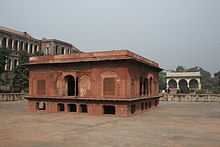
[మార్చు]In the middle between the two pavilions lies the Zafar Mahal. This structure was constructed during the reign of Bahadur Shah II in 1842 and named after him. This pavilion stands in the middle of a pre-existing water tank. It is made out of red sandstone, which was cheaper than white marble. Originally a red sandstone bridge led into the pavilion, which was probably lost after the Indian Rebellion of 1857. After the occupation in 1857, the tank was used for a while as a swimming pool by the British troops.[2]
Mehtab Bagh
[మార్చు]West of the garden was another one called Mehtab Bagh, or the "moon garden". This garden was completely destroyed by the British after the failed rebellion and four large military barracks constructed on its spot. There are plans to restore the garden.
Near the northwest corner is a baoli tank. The road from the baoli leads due south to the Delhi Gate of the fort.[1]
మూలాలు
[మార్చు]- ↑ 1.0 1.1 1.2 Murray, John (1911). A handbook for travellers in India, Burma, and Ceylon (8th ed.). Calcutta: Thacker, Spink, & Co. p. 198. ISBN 978-1175486417. Retrieved 2014-01-25.
- ↑ 2.0 2.1 "Hayat-Bakhsh Garden and Pavilions". Archaeological Survey of India. 2011. Archived from the original on 2014-02-07. Retrieved 2013-12-20.
