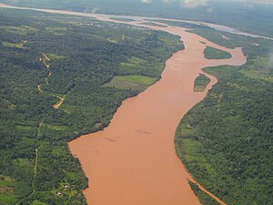
యుకాయాలి నది
Jump to navigation
Jump to search
This పేజీకి ఏ ఇతర పేజీల నుండి లింకులు లేకపోవడం చేత ఇదొక అనాథ పేజీగా మిగిలిపోయింది. |
| Ucayali River | |
Confluence of the Tambo (from bottom) and Urubamba Rivers (background right) forming the Ucayali River (background left)
| |
| దేశం | Peru |
|---|---|
| Source | confluence of the Tambo and Urubamba Rivers |
| - స్థలం | Atalaya, Ucayali, Peru |
| Mouth | Amazon River |
| - location | confluence with Marañón River, Loreto, Peru |
| పొడవు | 1,460 km (907 mi) [1] |
| Discharge | |
| - సరాసరి | 13,500 m3/s (4,76,748 cu ft/s) |
|
Map of the Amazon Basin with the Ucayali River highlighted
| |
యుకాయాలి నది (Ucayali River - యుకాయాలి రివర్) అనేది పెరూ దేశం యొక్క ఆరెక్వీప ప్రాంతంలో టిటికాకా సరస్సుకు ఉత్తరంగా దాదాపు 110 కి.మీ (68 మైళ్లు) దూరమున ఉద్భవిస్తున్న నది. దీని యొక్క పేరును నౌటా నగరం దగ్గర మరానోన్, యుకాయాలి నదుల సంగమంతో అమెజాన్ నది స్వీకరిస్తుంది. యుకాయాలి నది అమెజాన్ నది యొక్క ప్రధాన ఉపనది అవుతుంది. పుకల్పా నగరం ఈ యుకాయాలి నది ఒడ్డున ఉన్నది. ఈ యుకాయాలి నది అపురిమాక్ నది, ఈనే నది, టాంబో నదులతో కలిసి నేడు అమెజాన్ నది యొక్క ప్రధాన జన్మస్థానము అని భావించబడుతుంది.
ఈ నది యొక్క మొత్తం పొడవు నెవాడో మిస్మి వద్ద అపురిమాక్ మూలం నుండి యుకాయాలి, మరానోన్ నదుల సంగమం వరకు 2,669.9 కిలోమీటర్లు (1,659.0 మైళ్ళు):
- అపురిమాక్ నది (మొత్తం పొడవు): 730.7 కిలోమీటర్లు (454.0 మైళ్ళు)
- ఈనే నది (మొత్తం పొడవు): 180.6 కిలోమీటర్లు (112.2 మైళ్ళు)
- టాంబో నది (మొత్తం పొడవు): 158.5 కిలోమీటర్లు (98.5 మైళ్ళు)
- యుకాయాలి నది (టాంబో నదితో సంగమం నుంచి మరానోన్తో సంగమం వరకు):1,600.1 కిలోమీటర్లు (994.3 మైళ్ళు)
మూలాలు
[మార్చు]- ↑ Ziesler, R.; Ardizzone, G.D. (1979). "Amazon River System". The Inland waters of Latin America. Food and Agriculture Organization of the United Nations. ISBN 92-5-000780-9. Archived from the original on 8 November 2014.

