మూస:Infobox India district/doc
| This is a documentation subpage for మూస:Infobox India district. It may contain usage information, categories and other content that is not part of the original మూస page. |
Usage
[మార్చు]{{Infobox India district
| Name =
| Local =
| State =
| Division =
| Established =
| HQ =
| Map =
| Coordinates =
| Area =
| Area_footnotes =
| Year =
| Population =
| Population_footnotes =
| Density_footnotes =
| Urban =
| Literacy =
| SexRatio =
| Collector =
| Tehsils =
| LokSabha =
| Assembly =
| Highways =
| Vehicle =
| Rain =
| Website =
}}
Examples
[మార్చు]Example1 (from enwp)
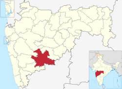
[మార్చు]షోలాపూర్ జిల్లా
सोलापूर जिल्हा | |
|---|---|
 మహారాష్ట్ర పటంలో షోలాపూర్ జిల్లా స్థానం | |
| దేశం | భారతదేశం |
| రాష్ట్రం | మహారాష్ట్ర |
| డివిజను | పూణె విభాగము |
| ముఖ్య పట్టణం | షోలాపూర్ |
| మండలాలు | 1. Akkalkot, 2. Barshi, 3. Karmala, 4. Madha, 5. Mangalwedha, 6. Malshiras, 7. Mohol, 8. North Solapur, 9. Pandharpur, 10. Sangola, 11. South Solapur |
| Government | |
| • లోకసభ నియోజకవర్గాలు | 1. Solapur(SC), 2. Madha (shared with Satara district), 3. Osmanabad (shared with Osmanabad district) (Based on Election Commission website) |
| • శాసనసభ నియోజకవర్గాలు | 10 |
| విస్తీర్ణం | |
| • మొత్తం | 14,845 కి.మీ2 (5,732 చ. మై) |
| జనాభా (2001) | |
| • మొత్తం | 38,49,543 |
| • జనసాంద్రత | 260/కి.మీ2 (670/చ. మై.) |
| • Urban | 31.83% |
| జనాభా వివరాలు | |
| • అక్షరాస్యత | 71.2% |
| • లింగ నిష్పత్తి | 935 |
| Vehicle registration | MH-13 |
| ప్రధాన రహదార్లు | NH-9, NH-13, NH-211 |
| అక్షాంశ రేఖాంశాలు | 17°21′N 75°10′E / 17.35°N 75.16°E - 18°19′N 76°09′E / 18.32°N 76.15°E |
| సగటు వార్షిక వర్షపాతం | 545.4 మి.మీ. |
| Website | అధికారిక జాలస్థలి |
{{Infobox India district
| Name        = షోలాపూర్
| Local       = सोलापूर जिल्हा
| State       = మహారాష్ట్ర
| Division    = [[పూణె విభాగము]]
| HQ          = షోలాపూర్
| Map         = Solapur in Maharashtra (India).svg
| Coordinates = {{coord|17.35|75.16}} - {{coord|18.32|76.15}}
| Area        = 14845
| Population  = 38,49,543
| Year        = 2001
| Urban       = 31.83%
| Literacy    = 71.2%
| SexRatio    = 935
| Tehsils     = 1. [[Akkalkot]], 2. [[Barshi]], 3. [[Karmala]], 4. [[Madha, Maharashtra|Madha]], 5. [[Mangalwedha]], 6. [[Malshiras]], 7. [[Mohol]], 8. [[North Solapur]], 9. [[Pandharpur]], 10. [[Sangola]], 11. [[South Solapur]]
| LokSabha    = 1. [[Solapur (Lok Sabha constituency)|Solapur(SC)]], 2. [[Madha (Lok Sabha constituency)|Madha]] (shared with [[Satara district]]), 3. [[Osmanabad (Lok Sabha constituency)|Osmanabad]] (shared with [[Osmanabad district]]) (Based on [http://164.100.9.199/ecimaps/ecipdf/state_pc_Map/Maharashtra.pdf Election Commission website])
| Assembly    = 10
| Highways    = [[National Highway 9 (India)|NH-9]], [[National Highway 13 (India)|NH-13]], [[National Highway 211 (India)|NH-211]]
| Vehicle     = MH-13
| Rain        = 545.4
| Website     = http://solapur.gov.in/
}}
Example 2 (తెవికీ)
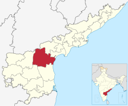
[మార్చు]ప్రకాశం జిల్లా | |
|---|---|
 ఆంధ్ర ప్రదేశ్ పటంలో ప్రకాశం జిల్లా స్థానం | |
| దేశం | భారతదేశం |
| రాష్ట్రం | ఆంధ్ర ప్రదేశ్ |
| డివిజను | ప్రకాశం జిల్లా |
| ముఖ్య పట్టణం | ఒంగోలు |
| Government | |
| • జిల్లా కలెక్టరు | వాడరేవు వినయచంద్ |
| • లోకసభ నియోజకవర్గాలు | బాపట్ల (SC) (Lok Sabha constituency), Ongole (Lok Sabha constituency) |
| • శాసనసభ నియోజకవర్గాలు | 12 |
| విస్తీర్ణం | |
| • మొత్తం | 17,626 కి.మీ2 (6,805 చ. మై) |
| జనాభా (2011)[1] | |
| • మొత్తం | 33,97,448 |
| • జనసాంద్రత | 190/కి.మీ2 (500/చ. మై.) |
| జనాభా వివరాలు | |
| • అక్షరాస్యత | 63.53% |
| • లింగ నిష్పత్తి | 981 |
| Vehicle registration | AP-09 |
| ప్రధాన రహదార్లు | NH-5 |
| అక్షాంశ రేఖాంశాలు | 15°20′N 79°33′E / 15.333°N 79.550°E |
| Website | అధికారిక జాలస్థలి |
{{Infobox India district
| Name        = ప్రకాశం
| Local       =
| State       = ఆంధ్ర ప్రదేశ్
| Division    = ప్రకాశం జిల్లా
| HQ          = ఒంగోలు
| Map         = Prakasam in Andhra Pradesh (India).svg
| Coordinates = {{coord|15|20|N|79|33|E|type:adm3rd_region:IN_dim:200000|display=inline,title}}
| Area        = 17626
| Population  = 3397448
| Population_footnotes=<ref>{{Cite web|url=http://prakasam.ap.gov.in/Cencus.apo|archiveurl=https://web.archive.org/web/20170723061059/http://prakasam.ap.gov.in|title=Census 2011|date=2012|archivedate=2017-07-23}}</ref>
| Density_footnotes=
| Year        = 2011
| Urban       =
| Literacy    = 63.53%
| SexRatio    = 981
| Collector   = వాడరేవు వినయచంద్
| LokSabha    = [[బాపట్ల (SC) (Lok Sabha constituency)]], [[Ongole (Lok Sabha constituency)]]
| Assembly    = [[Andhra Pradesh Legislature#Legislative Assembly Constituencies|12]]
| Highways    = [[National Highway 5 (India)(old numbering)|NH-5]]
| Vehicle     = AP-09
| Rain        =
| Website     = http://www.prakasam.ap.gov.in/login.apo/
}}
Microformats
[మార్చు]The HTML markup produced by this template includes an hCard microformat, which makes the place-name and location parsable by computers, either acting automatically to catalogue articles across Wikipedia, or via a browser tool operated by a person, to (for example) add the subject to an address book. Within the hCard is a Geo microformat, which additionally makes the coordinates (latitude & longitude) parsable, so that they can be, say, looked up on a map, or downloaded to a GPS unit. For more information about the use of microformats on Wikipedia, please see the microformat project.
Sub-templates
[మార్చు]If the place or venue has "established", "founded", "opened" or similar dates, use {{start date}} for the earliest of those dates unless the date is before 1583 CE.
If it has a URL, use {{URL}}.
Please do not remove instances of these sub-templates.
Classes
[మార్చు]hCard uses HTML classes including:
- adr
- agent
- category
- county-name
- extended-address
- fn
- label
- locality
- nickname
- note
- org
- region
- street-address
- uid
- url
- vcard
Geo is produced by calling {{coord}}, and uses HTML classes:
- geo
- latitude
- longitude
Please do not rename or remove these classes nor collapse nested elements which use them.
Precision
[మార్చు]When giving coordinates, please use an appropriate level of precision. Do not use {{coord}}'s |name= parameter.
- ↑ "Census 2011". 2012. Archived from the original on 2017-07-23.
