అటకామా ఎడారి
| Atacama Desert | |
| Desert | |
 Atacama by NASA World Wind
| |
| Countries | Chile, Peru, Bolivia, Argentina |
|---|---|
| వైశాల్యం | 1,05,000 km2 (40,541 sq mi) |
| Biome | Desert |
 Map of Atacama Desert. The area most commonly defined as Atacama is yellow. In orange are the outlying arid areas of Sechura Desert, Altiplano, Puna de Atacama and Norte Chico.
| |
అటకామా ఎడారి (ఆంగ్లం: Atacama Desert), దక్షిణ అమెరికా ఖండంలో ఉంది. ఈ ఎడారిలో వర్షపాతం దాదాపు శూన్యం. దక్షిణ అమెరకా పశ్చిమాన, పసిఫిక్ మహాసముద్రం తీరంలో యాండీస్ పర్వతశ్రేణికి పశ్చిమాన ఉన్న సన్నని భూభాగంలో ఉన్న ఈ ఎడారి 1000 కి.మీ. (600మైళ్ళు) పొడవున విస్తరించి ఉంది. నాసా, నేషనల్ జియొగ్రాఫిక్, మరికొన్ని ప్రచురణల ప్రకారం అటకామా ఎడారి ప్రపంచంలో అత్యంత పొడి ఎడారి (driest desert)[1][2][3]
యాండీస్ పర్వతాలు, చిలీ తీర పర్వతాల కారణంగా ఏర్పడిన వర్షచ్ఛాయా ప్రాంతం, చల్లని భూభాగపు "హంబోల్ట్ కరెంట్ (Humboldt Current) కారణంగా ఈ ఎడారి ఏర్పడింది. ఈ ఎడారి వయసు 200 మిలియన్ సంవత్సరాలు.[4] కాలిఫోర్నియాలో ప్రసిద్ధి చెందిన "మృత్యులోయ" (Death Valley) కంటే ఈ ఎడారి 50 రెట్లు ఎక్కువ పొడి అయినది. ఉత్తర చిలీలో విస్తరించి ఉన్నఈ ఎడారి వైశాల్యం 181,300 చదరపు కిలోమీటర్లు (70,000 mi²)[5] ఇందులో ఆధిక భాగం ఉప్పు బేసిన్లు, ఇసుక, లావా రాళ్ళు.
చిత్రమాలిక[మార్చు]
-
 అటకామా ఎడారి
 -
 Scene from Valle de la Luna (Moon Valley) near San Pedro de Atacama.
 -
 "Icy Penitents by Moonlight"
 -

-
 Valley in Atacama
 -
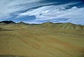
 Vista before sunset.
 -
-

-

-

-
 Machuca capilla
 -
![ALMA Movie poster[6]](//upload.wikimedia.org/wikipedia/commons/thumb/8/88/ALMA_Movie_poster.jpg/85px-ALMA_Movie_poster.jpg) ALMA Movie poster[6]
ALMA Movie poster[6] -
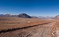
 Atacama road
 -
 Atacama lizard
 -
 Andean flamingos in Salar de Atacama


.jpg)


![ALMA Movie poster[6]](/wiki/%E0%B0%A6%E0%B0%B8%E0%B1%8D%E0%B0%A4%E0%B1%8D%E0%B0%B0%E0%B0%82:ALMA_Movie_poster.jpg)


ఇవి కూడా చూడండి[మార్చు]
మూలాలు[మార్చు]
- ↑ "ఆర్కైవ్ నకలు". Archived from the original on 2007-12-18. Retrieved 2009-06-08.
- ↑ "ఆర్కైవ్ నకలు". Archived from the original on 2009-04-08. Retrieved 2009-06-08.
- ↑ "ఆర్కైవ్ నకలు" (PDF). Archived from the original (PDF) on 2012-06-06. Retrieved 2009-06-08.
- ↑ Tibor, Dunai(Dr.). Amazing Nature. http://www.nature-blog.com/2007/10/atacama-desert-dryest-place-on-earth.html Archived 2008-08-28 at the Wayback Machine. Retrieved 3/24/08
- ↑ Wright, John W. (2006). The New York Times Almanac (2007 ed.). New York, New York: Penguin Books. p. 456. ISBN 0-14-303820-6.
- ↑ "New Movie: ALMA — In Search of Our Cosmic Origins". ESO. Retrieved 2 April 2013.
యితర లింకులు[మార్చు]
- "Mars-like Soils in the Atacama Desert, Chile, and the Dry Limit of Microbial Life", NASA press release
- "Roving robot finds desert life", article in Nature
- Photos of Atacama Desert landscape, flora and fauna
- "A Lady in the Atacama Desert, from the travel blog A Lady in London
- Deatiled article issued by the Geological Society of America on the history of aridity of the Atacama Desert