ఘాజీపూర్
ఘాజీపూర్ | |
|---|---|
పట్టణం | |
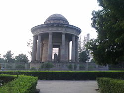
 లార్డ్ కారన్వాలీస్ సమాధి | |
| Coordinates: 25°35′N 83°34′E / 25.58°N 83.57°E | |
| దేశం | |
| రాష్ట్రం | ఉత్తర ప్రదేశ్ |
| జిల్లా | ఘాజీపూర్ |
| Founded by | సయ్యద్ మసూద్ ఘాజీ |
| విస్తీర్ణం | |
| • Total | 20 కి.మీ2 (8 చ. మై) |
| జనాభా (2011) | |
| • Total | 1,21,136 |
| • Rank | 391 |
| • జనసాంద్రత | 6,056/కి.మీ2 (15,680/చ. మై.) |
| • లింగనిష్పత్తి | 902 ♀/♂ |
| భాషలు | |
| • అధికారిక | హిందీ |
| Time zone | UTC+5:30 (IST) |
| PIN | 233001 |
| టెలిఫోన్ కోడ్ | 91-548 |
ఘాజీపూర్, ఉత్తర ప్రదేశ్ రాష్ట్రంలోని పట్టణం. ఘాజీపూర్ జిల్లాకు ముఖ్యపట్టణం.ఇది వారణాసి డివిజనులో భాగం. ఘాజీపూర్ పట్టణం ఘాజీపూర్ జిల్లాలోని ఏడు విభిన్న తహసిల్స్ లేదా ఉపవిభాగాలలో ఒకటి.[1] ఘాజీపూర్, ఉత్తర ప్రదేశ్- బీహార్ సరిహద్దుకు సమీపంలో వారణాసి నుండి సుమారు 80 కి.మీ. దూరంలో ఉంది[2]
ఘాజీపూర్ నల్లమందు కర్మాగారానికి ప్రసిద్ధి చెందింది. దీనిని బ్రిటిష్ ఈస్ట్ ఇండియా కంపెనీ 1820 లో స్థాపించింది. ఇప్పటికీ ప్రపంచంలోనే అతిపెద్ద చట్టబద్దమైన నల్లమందు కర్మాగారం ఇది. ప్రపంచవ్యాప్తంగా ఔషధ పరిశ్రమ కోసం ఇక్కడ నల్లమందు ఉత్పత్తి అవుతుంది.[3]
భౌగోళికం
[మార్చు]ఘాజీపూర్ 25°35′N 83°34′E / 25.58°N 83.57°E నిర్దేశాంకాల వద్ద [4] సముద్రమట్టం నుండి 62 మీటర్ల ఎత్తున ఉంది.
జనాభా
[మార్చు]2011 జనాభా లెక్కల ప్రకారం, ఘాజీపూర్ పట్టణ సముదాయంలో 1,21,136 జనాభా ఉంది, వీరిలో పురుషులు 63,689, మహిళలు 57,447. జనాభాలో పురుషులు 52.57% ఉండగా, జనాభాలో ఆడవారు 47.43% ఉన్నారు. ఘాజీపూర్ పట్టణ సముదాయం అక్షరాస్యత రేటు 84.97% (జాతీయ సగటు 74.04% కన్నా ఎక్కువ), ఇందులో పురుషుల అక్షరాస్యత 90.23%, స్త్రీ అక్షరాస్యత 79.17%. ఘాజీపూర్ పట్టణ సముదాయాల లింగ నిష్పత్తి 902. ఘాజీపూర్ పట్టణ సముదాయంలో ఘాజీపూర్ పట్టణంతో పాటు, కపూర్పూర్, మిశ్రోలియా, మాధోపూర్, రజ్దేపూర్ ఉన్నాయి.[5]
2011 నాటికి [6] ఖాజీపూర్ పట్టణంలో 1,10,698 జనాభా ఉంది, వీరిలో పురుషులు 58,126, మహిళలు 52,572. జనాభాలో పురుషులు 52.5%, మహిళలు 47.5%. ఘాజీపూర్ అక్షరాస్యత 85.46% (జాతీయ సగటు 74.04% కన్నా ఎక్కువ), ఇందులో పురుషుల అక్షరాస్యత 90.61%, స్త్రీ అక్షరాస్యత 79.79%. ఆరేళ్ళ లోపు పిల్లలు జనాభాలో 11.46% ఉన్నారు. పిల్లల్లో లింగ నిష్పత్తి 904.
శీతోష్ణస్థితి
[మార్చు]| శీతోష్ణస్థితి డేటా - Ghazipur (1981–2010, extremes 1978–2012) | |||||||||||||
|---|---|---|---|---|---|---|---|---|---|---|---|---|---|
| నెల | జన | ఫిబ్ర | మార్చి | ఏప్రి | మే | జూన్ | జూలై | ఆగ | సెప్టెం | అక్టో | నవం | డిసెం | సంవత్సరం |
| అత్యధిక రికార్డు °C (°F) | 30.6 (87.1) |
34.1 (93.4) |
40.1 (104.2) |
45.1 (113.2) |
46.1 (115.0) |
46.4 (115.5) |
43.2 (109.8) |
37.2 (99.0) |
37.6 (99.7) |
36.0 (96.8) |
34.0 (93.2) |
30.8 (87.4) |
46.4 (115.5) |
| సగటు అధిక °C (°F) | 21.4 (70.5) |
25.4 (77.7) |
31.5 (88.7) |
37.6 (99.7) |
38.7 (101.7) |
37.0 (98.6) |
33.0 (91.4) |
32.3 (90.1) |
31.9 (89.4) |
30.9 (87.6) |
27.6 (81.7) |
23.4 (74.1) |
30.9 (87.6) |
| సగటు అల్ప °C (°F) | 7.2 (45.0) |
10.0 (50.0) |
14.2 (57.6) |
19.8 (67.6) |
23.5 (74.3) |
25.0 (77.0) |
24.4 (75.9) |
24.1 (75.4) |
23.2 (73.8) |
19.0 (66.2) |
13.0 (55.4) |
8.6 (47.5) |
17.7 (63.9) |
| అత్యల్ప రికార్డు °C (°F) | −0.5 (31.1) |
3.5 (38.3) |
6.2 (43.2) |
11.0 (51.8) |
16.0 (60.8) |
19.5 (67.1) |
20.0 (68.0) |
19.0 (66.2) |
18.2 (64.8) |
10.0 (50.0) |
5.7 (42.3) |
1.5 (34.7) |
−0.5 (31.1) |
| సగటు వర్షపాతం mm (inches) | 13.9 (0.55) |
15.7 (0.62) |
7.2 (0.28) |
6.6 (0.26) |
23.2 (0.91) |
106.7 (4.20) |
306.9 (12.08) |
278.8 (10.98) |
215.9 (8.50) |
27.2 (1.07) |
7.5 (0.30) |
4.4 (0.17) |
1,014.1 (39.93) |
| సగటు వర్షపాతపు రోజులు | 1.5 | 1.3 | 0.7 | 0.5 | 1.9 | 6.0 | 12.7 | 12.3 | 8.5 | 1.9 | 0.5 | 0.4 | 48.2 |
| సగటు సాపేక్ష ఆర్ద్రత (%) (at 17:30 IST) | 69 | 60 | 43 | 29 | 37 | 54 | 76 | 78 | 78 | 71 | 66 | 68 | 61 |
| Source: India Meteorological Department[8][9] | |||||||||||||
పట్టణ ప్రముఖులు
[మార్చు]- లార్డ్ కార్న్వాలిస్, ఉత్తర అమెరికా, ఐర్లాండ్, భారతదేశాల వలస పాలనాధికారి ఇక్కడే మరణించాడు
- భారతదేశపు అత్యున్నత సైనిక పురస్కారం పరమ వీర చక్ర గ్రహీత అబ్దుల్ హమీద్
- భారతదేశంలో స్వేచ్ఛ యొక్క స్పార్క్ పెంచిన మొదటి హీరో సిపాయి మంగళ్ పాండే
- విద్యావేత్త, సంఘ సంస్కర్త సయీదా ఫైజ్
మూలాలు
[మార్చు]- ↑ "Tehsil | District Ghazipur, Government of Uttar Pradesh | India,"
- ↑ "Sir Sayed Ahmad Khan|Books".
{{cite web}}: CS1 maint: url-status (link)[permanent dead link] - ↑ Paxman, Jeremy (2011). "Chapter 3". Empire:What Ruling the World Did to the British. London: Penguin Books.
- ↑ "Falling Rain Genomics, Inc – Ghazipur". Fallingrain.com. Retrieved 8 April 2012.
- ↑ "Urban Agglomerations/Cities having population 1 lakh and above" (PDF). Provisional Population Totals, Census of India 2011. Retrieved 7 July 2012.
- ↑ "Census of India 2001: Data from the 2001 Census, including cities, villages and towns (Provisional)". Census Commission of India. Archived from the original on 16 June 2004. Retrieved 1 November 2008.
- ↑ "Census 2011 Ghazipur". Census 2011. Retrieved 7 July 2017.
- ↑ "Station: Gazipur Climatological Table 1981–2010" (PDF). Climatological Normals 1981–2010. India Meteorological Department. January 2015. pp. 287–288. Archived from the original (PDF) on 5 February 2020. Retrieved 6 May 2020.
- ↑ "Extremes of Temperature & Rainfall for Indian Stations (Up to 2012)" (PDF). India Meteorological Department. December 2016. p. M215. Archived from the original (PDF) on 5 February 2020. Retrieved 6 May 2020.

